
Collundtspark
| Collundtspark | |
|---|---|
|
|
|
| Basic data | |
| place | Flensburg |
| District | Neustadt |
| Created | approx. 17./18. century |
| Newly designed | 1991/92 |
| Surrounding streets | Schlossstrasse, Duburger Strasse |
| Buildings | modern artificial ruin |
| use | |
| User groups | pedestrian |
| Technical specifications | |
| Parking area | 8,000 m² |
Collundtspark (also shorter: Collundspark ; more rarely: Collundtsgarten ) is a park in the city of Flensburg , in the Duburg district , which is located on a slope above the Flensburg city center , in an area of the street triangle Schloßstraße , Duburger Straße and Norderstraße .
background
The Collundtspark was probably originally laid out in the Baroque period and is said to have taken up an area of around 15 hectares. To the south of the Collundtspark and the adjoining Schloßstraße there was probably still the Schloßpark in the Baroque era, Duburg , which was in decline . In the Middle Ages, the St. Gertrud Chapel (see St. Gertrud ) with the associated cemetery, which existed until the beginning of the 19th century, was located directly below the Collundtspark . In the 1840s, the Collundtspark was used as a summer garden. In 1881/82 the Voigt School was built at the southern entrance to the park . In 1888 the garden restaurant in the park, the Collundtsche Gartenlaube, was closed.
At Collundtspark there is said to have been a bread factory called "Viktoria" during the First World War , which was plundered in 1917 by starving people. Until 1920 the Collundtspark was owned by the Lorenzen Collundts family of boatmen and shipowners. In 1983 the Collundt gazebo burned down. In 1985 the dilapidated park area became part of a redevelopment area. In 1991/92 the dilapidated park was redesigned under the aspect of ecological urban redevelopment. The aim of the park renovation was in particular to increase the quality of stay in the park for the surrounding residents. Foundations and remains of the basement, which are said to be around a hundred years old, have obviously been redesigned into a modern art ruin , which should arouse associations with castle ruins.
From the originally larger park, the core area of 0.8 hectares on the edge of the Gertrudenviertel has been preserved to this day . The preserved park is thus considerably smaller than the largest park in the city, the Volkspark, and yet larger than the smallest park in the city, the Fleno-Park . The park's network of paths extends from Schloßstraße to Duburger Straße. (The route to Duburger Straße was added in 2007/2008.) The park area is home to various trees and shrubs. Rare or exotic plants from earlier times have not been preserved. Nowadays, however, the Collundtspark is obviously in bad shape again. Garbage lying around endangers the trees and the natural areas of the park.

Access to Collundspark from Schloßstraße (2013)

Walkway of the Collundtspark (2013)

Area of the Collundtspark (2013)
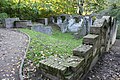
Building ruins in Collundspark (2013)
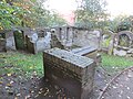
Building ruins from another perspective (2013)

Further access to the park from the north side (2013)
.JPG)
,_Bild_01.JPG)
,_Bild_01.JPG)
,_Bild_01.JPG)
,_Bild_03.JPG)
.JPG)
Individual evidence
- ↑ a b c d e f g h Andreas Oeding, Broder Schwensen, Michael Sturm: Flexikon . 2009, article: Collundtspark
- ↑ a b c Lutz Wilde : Monument topography Federal Republic of Germany, cultural monuments in Schleswig-Holstein. Volume 2, Flensburg, p. 254.
- ↑ a b c d e f g h Flensburg projects booklet 5. 25 years of urban redevelopment in Flensburg. Northern old town, object 19
- ↑ Ev.-Luth. Parish of St. Gertrud zu Flensburg , accessed on: November 18, 2018.
- ↑ Guided tour in Flensburg: Secrets of the northern old town. In: Flensburger Tageblatt . November 8, 2017; accessed on: November 18, 2018.
- ↑ City history: Flensburg in the bitter years. In: Flensburger Tageblatt. November 2, 2009; accessed on: November 24, 2018.
- ↑ Draft Statute of Citizens' Participation Anl HA-68-2014 - SPD-NET-SH , accessed on: November 18, 2018 and Planethome. Property. Flensburg 2017/2018 , p. 5, accessed on: November 18, 2018.
- ↑ Flensburg. Leisure offers. Christiansenpark , accessed on: November 10, 2019
- ↑ Green in the old town of Flensburg: Quirky oasis for lovers. In: Flensburger Tageblatt. July 27, 2018; accessed on: November 18, 2018.
Web links
Coordinates: 54 ° 47 ′ 40.7 " N , 9 ° 25 ′ 47.5" E