
Volkspark (Flensburg)
| Volkspark | |
|---|---|
|
|
|
| Basic data | |
| place | Flensburg |
| District | Fruerlund |
| Created | 1925 (successor park to the old Mürwiker Park from 1641) |
| Surrounding streets | At the Volkspark (Ved Folkeparken) |
| Buildings | Mürwiker water tower , garden colonies, stadiums , sports facilities, playgrounds, lawns and park benches |
| use | |
| User groups | Pedestrians , leisure |
| Technical specifications | |
| Parking area | 750,000 m² |
The Volkspark ( Danish Folkeparken ) is a park in Flensburg , above the Flensburg Fjord in the Fruerlund district . It consists of numerous allotments , sidewalks, large stands of trees and the Flensburg stadium . The Mürwiker water tower is also located in the Volkspark .
history
Predecessor of the Volkspark


In Flensburg there were various parks long before the creation of the Volkspark, but they were designed differently, served different purposes and aimed at a different audience. For example, the Christiansenpark , which is still preserved today and was built near Westliche Höhe at the end of the 18th century , was privately owned. The city park established at the beginning of the 20th century near Christiansenpark and near the deaconess hospital was, in contrast to this, a park for the public to stroll through. The Carlisle Park , created shortly after the Volkspark, forms the public area in front of the train station, where the mill pond had previously been located.
But also in the east of the city there was a large and even well-known park in front of the Volkspark, which was located north of Ziegeleistraße in the nucleus of Mürwik , i.e. not particularly far from today's Volkspark, which is south of Ziegeleistraße. The said old Mürwiker Park is said to have been laid out by a Dutchman named Johann Cornelius , according to tradition . A stone in the old Mürwiker Park, which is still reminiscent of Johann Cornelius today, bears the inscription "1641", so that the stone was erected in the 17th century. The Mürwiker Park has changed hands several times since the 17th century.
The park was then largely designed in the 1830s by the owner of the Mürwiker Hof , the monastery governor of the monastery of the Holy Spirit Heinrich Göttig, who had previously worked as a merchant. The park housed a robber's cave (an artificial grotto), several goldfish ponds, Gesundbrunnen (a "holy" spring) garden houses, a pavilion, rare trees and shrubs, exotic flowers, various vegetables, statues, whale legs and other attractions. In the park there was also an artificial cemetery and a museum, which housed a collection of art and antiquity as well as natural objects.
In the 1850s, King Friedrich VII visited the park several times. Other famous visitors were the poet and writer Wilhelm Jensen , the Schleswig-Holstein patriot Uwe Jens Lornsen and the so-called health apostle Ernst Mahner . Incidentally, Göttig was a staunch abstainer . He published an entire pamphlet in which he advocated general abstinence in society. He was the first Schleswig-Holsteiner to write about this topic. Heinrich Göttig died in 1863 or not until 1868.
Later on, Göttigs Park was apparently built over gradually. In 1925/1928 the Parkhof , a residential courtyard in the style of homeland security architecture, was laid out. The residential complex was only given the name Parkhof on March 28, 1947. The name is intended to be a reminder of the Göttig park. A lion that used to stand in Mürwiker Park is now on the opposite bank, on the Museum Mountain . The lion, with its coat of arms on which there is a linden tree, is now registered as a cultural monument of the Friesischer Berg district. The already mentioned “Gründerstein” from the 17th century was moved to the Volkspark. Today it stands at the foot of the water tower and, with its presence, reminds us that the Volkspark followed and replaced the old Mürwiker Park.
The creation of the Volkspark
,_Bild_001.JPG)

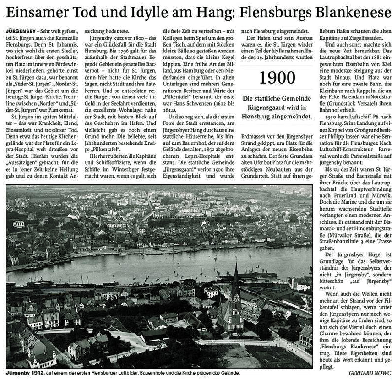
Thousands of years ago, the area of the later Volkspark with its three mountains, the Ballastberg, the Blasberg and the Finisberg , had evidently been formed by moraine deposits . When the Zeppelin Hansa flew over the city on August 11, 1912 and the first aerial photos of the city were taken, fields with curtsey of the Jürgensbyer Höfe were still visible on the site on which the Volkspark was to be laid out a few years later . There was hardly any tree growth.
The Volkspark was laid out in 1925. Apparently a real public park was planned , which should serve recreation and sporting activities. The stadium there was also built for this purpose. It was inaugurated on July 3, 1927. Thus, the Volkspark developed in the direction of the Altonaer Volkspark , which was created shortly before, in which the Altona Stadium was located at that time (today: Volksparkstadion ) and today's Hamburg City Park , as well as a little in the direction of the Olympic Park in the early 1970s Munich . At that time, a solstice site ( location ) was also created on the slope edge and the honor grove . During the Second World War , the Volkspark was less well maintained. In the post-war period, some of the equipment, including some of the fences, was lost due to theft. The greatest damage was caused by the theft of wood. From 1947 onwards, the site was gradually expanded and redesigned. After the Second World War, allotment gardens were created at the Volkspark, which initially served for self-sufficiency. In the southern area of the Volkspark, the park was greatly expanded from 1960 to include allotment gardens. In 1957, a high path was laid out along the edge of the slope. At the same time, the bridge over the "Wolfsschlucht" was built in the north. In 1959 the Flensburg University of Education moved to the edge of the Volkspark, where it remained until the end of the 1990s. In 1961 the Mürwiker water tower was built in the middle of the Volkspark and established itself as a landmark of the Volkspark. In 1962 it was considered to set up a botanical garden and a water zoo on the site. However, the plans were not implemented. A kind of small zoo (or zoo or animal park) later existed with the Hansi garden at Twedter Plack , an ornamental bird breeding that could be visited that existed until the 1980s. In the 20th century, boulders with inscriptions were placed in the Volkspark to commemorate three of the supporters of the Volkspark. A fitness trail has also been set up.
In the following years, the Volkspark became a photo motif of the city. It also served as a picture postcard. It gained in tourist importance.
The Volkspark since the beginning of the 21st century
Since 1989, the maintenance concept for the Volkspark has been changed and natural overgrowth has been initiated in large parts of the park. In 2004 the previously abandoned building of the college of education was demolished, which meant that an element of identity in the Fruerlund district was lost. The former site of the college of education was built on by the SBV in 2006/2007. Offices, practices, 69 assisted elderly apartments and a large supermarket were built on the 5.2 hectare area. As well as some single-family houses. Since the beginning of the new century, the two urban parks on the east bank have been visibly overgrown because of the savings in maintenance measures. In particular, the overgrowth of the Volkspark led to criticism from the population. In 2012, the city's nature conservation officer, Jürgen Uwe Maßheimer, complained that the Twedter Mark landscape park was not properly maintained .
Due to new buildings in 2014, grounds were permanently withdrawn from the Volkspark or built with apartments for purposes other than those intended. The project in question is being implemented by a consortium consisting of the SBV, the Höft construction company and Bauplan Nord. The architect Axel Waltje explained the location and design of the project: "All houses will be in a park". Urban planning boss Peter Schroeder declared at the end of 2014 that the construction area at the water tower was one of the current urban model projects of the city of Flensburg. In 2017, the development of the area, which used to be allotment gardens, should be completed.
In 2016, an alliance of all council groups, with the exception of the abstaining CDU, was formed to secure and upgrade these parks.
The Volkspark nowadays
The Volkspark area has a size of approximately 75 hectares. The area of the Volkspark is one of the landscape protection areas of the city of Flensburg .
Nowadays the Volkspark is suitable for hiking, picnicking and jogging. In the summer months, the water tower can also be climbed and used as a lookout point. Some of the facilities in the Volkspark were registered as cultural monuments of the city of Flensburg . The Flensburg Youth Hostel is located on the edge of the Volkspark in the north . The Baltic Sea Cycle Route (EV10) runs along it. Furthermore, the hotel at the water tower on the eastern edge provides the opportunity to spend the night. In winter, some of the slopes of the Volkspark are used as toboggan runs . The Volkspark also has two very large children's playgrounds, one in the south and one in the north of the park, where there are also viewpoints from the Volkspark.

The little lion used to stand in the old Mürwiker Park. Today it is at the Museumsberg .

The water tower that used to stand in the middle of the Volkspark. (Photo 2014)

Garden colony 115 at the water tower in the Volkspark

Memorial stone to one of the supporters of the Volkspark

The now demolished university
.JPG)
,_Bild_01.JPG)
,_Bild_01.jpg)


,_Bild_03.JPG)
Mountain areas
Roughly speaking, the Volkspark consists of three altitudes, which, as already mentioned, evidently arose thousands of years ago in the course of frequent moraine deposits. The Mürwiker water tower further south stands on a hill of about 47 m above sea level. NN . This altitude area further south is called Ballastberg . With regard to the naming cf. Ballast bridge . The Flensburg Stadium is located in the immediate vicinity of the Blasberg residential area and is located at an altitude of around 39 m above sea level. Should be located NN . Further northeast beyond the “Wolfsschlucht”, in the furthest corner of the Volkspark, is the third altitude of the Volkspark, the Finisberg . There at Finisberg is a large meadow from which you can look down to the Flensburg Fjord and from which you can also see the Mürwik Naval School ( Red Castle ) in the distance. The name Finisberg has been attested since the end of the 18th century and refers to a Venusberg . The Finisberg was used for glider flights by the Kielseng glider air base between 1923 and 1932 . (Incidentally, Finisberg is also the name of an adjacent street today; cf. street name Finisberg ) - At the various altitudes of the Volkspark, viewpoints can be found today, from which one can look down to the Flensburg Fjord.
Individual evidence
- ^ Lutz Wilde: Monument topography Federal Republic of Germany, cultural monuments in Schleswig-Holstein. Volume 2, Flensburg, page 546
- ↑ a b c d e f g h Andreas Oeding, Broder Schwensen, Michael Sturm: Flexikon. 725 aha experiences from Flensburg! , Flensburg 2009, article: Volkspark
- ↑ Ludwig Rohling u. a .: Art monuments of the city of Flensburg. Munich 1955, page 550
- ^ Official announcement on the development plan for the senior center Swinemünder Straße , page 16, from: April 15, 2015; Retrieved on: December 19, 2015
- ^ Andreas Oeding, Broder Schwensen, Michael Sturm: Flexikon. 725 aha experiences from Flensburg! , Flensburg 2009, article: Parkhof
- ↑ Flensburg street names . Society for Flensburg City History, Flensburg 2005, ISBN 3-925856-50-1 , article: Parkhof
- ↑ Gerret Liebing Schlaber: From the country to the district. Flensburg's Stadtfeld and the incorporated villages in pictures and words approx. 1860-1930. Flensburg 2009. page 137
- ↑ Flensburg street names . Society for Flensburg City History, Flensburg 2005, ISBN 3-925856-50-1 , article: Parkhof
- ^ Official announcement on the development plan for the senior center Swinemünder Straße , page 16, from: April 15, 2015; Retrieved on: December 19, 2015
- ^ Andreas Oeding, Broder Schwensen, Michael Sturm: Flexikon. 725 aha experiences from Flensburg! , Flensburg 2009, article: Parkhof
- ↑ Flensburg street names . Society for Flensburg City History, Flensburg 2005, ISBN 3-925856-50-1 , article: Parkhof
- ↑ Gerret Liebing Schlaber: From the country to the district. Flensburg's Stadtfeld and the incorporated villages in pictures and words approx. 1860-1930. Flensburg 2009. page 137
- ^ Andreas Oeding, Broder Schwensen, Michael Sturm: Flexikon. 725 aha experiences from Flensburg! , Flensburg 2009, article: Parkhof
- ↑ Flensburg street names . Society for Flensburg City History, Flensburg 2005, ISBN 3-925856-50-1 , article: Parkhof
- ↑ A single source says 1868: Portrait of Heinrich Göttig . On: museen-nord.de
- ^ Andreas Oeding, Broder Schwensen, Michael Sturm: Flexikon. 725 aha experiences from Flensburg! , Flensburg 2009, article: Parkhof
- ↑ Flensburg street names . Society for Flensburg City History, Flensburg 2005, ISBN 3-925856-50-1 , article: Parkhof
- ↑ Ludwig Rohling u. a .: Art monuments of the city of Flensburg. Munich 1955, page 550
- ^ Official announcement on the development plan for the senior center Swinemünder Straße , page 16, from: April 15, 2015; Retrieved on: December 19, 2015
- ↑ Flensburg. Leisure offers. Volkspark , accessed on: November 10, 2019
- ↑ Lonely death and idyll on the slope: Flensburgs Blankenese (or there ), from: July 4th, 2009; Retrieved on: February 25, 2018
- ^ Writings of the Society for Flensburg City History (ed.): Flensburg in history and present . Flensburg 1972, page 408
- ↑ Flensburg street names . Society for Flensburg City History, Flensburg 2005, ISBN 3-925856-50-1 , article: Am Volkspark
- ↑ Flensburg street names . Society for Flensburg City History, Flensburg 2005, ISBN 3-925856-50-1 , article: Am Volkspark
- ^ Lutz Wilde: Monument topography Federal Republic of Germany, cultural monuments in Schleswig-Holstein. Volume 2, Flensburg, page 520
- ^ Lutz Wilde: Monument topography Federal Republic of Germany, cultural monuments in Schleswig-Holstein. Volume 2, Flensburg, pages 520 and 124 f.
- ↑ a b c Marsch und Förde, Volkspark ; accessed on July 27, 2014
- ^ Andreas Oeding, Broder Schwensen, Michael Sturm: Flexikon. 725 aha experiences from Flensburg! , Flensburg 2009, article: Hansigarten
- ↑ Trim yourself path Flensburg ; accessed on July 27, 2014
- ^ SPD initiative: Who will save the urban parks? , dated: November 24, 2016; Retrieved on: May 3, 2018
- ↑ Urban garden art - from the imperial city park to the people's park for everyone , accessed on: July 23, 2017
- ^ Fruerlund, Urban Redevelopment in Flensburg, A quarter reinvents itself , Flensburg 2016, page 24
- ↑ Flensburger Tageblatt : A living oasis with lots of green: Building area at the Volkspark , from: September 24, 2010, accessed on: September 15, 2014
- ↑ Flensburger Tageblatt : Twedter Feld in Flensburg: Sprawling parks - citizens tackle , from: June 19, 2017; Retrieved on: May 3, 2018
- ^ SPD initiative: Who will save the urban parks? , dated: November 24, 2016; Retrieved on: May 3, 2018
- ↑ Flensburger Tageblatt : Ideas for a Forgotten Idyll , dated: August 20, 2012, accessed on: April 1, 2015
- ↑ Construction area at the water tower: Second attempt with runner-up , from: June 27, 2012, accessed on: September 15, 2014
- ↑ Plans for residential quarters: Exclusive living at the water tower , dated: October 2, 2013, accessed on: September 15, 2014
- ↑ Construction control procedure opened: Council brings old gardening shop on the way , from: September 15, 2014, accessed on: September 15, 2014
- ↑ Flensburger Tageblatt : The first move in in summer , from: April 25, 2015; Retrieved on: April 25, 2015
- ↑ Flensburger Tageblatt : Green spaces and finance in Flensburg: TBZ: Fresh money for the parks , from: April 11, 2017; Retrieved on: May 3, 2018
- ↑ See Hotel am Wasserturm ; Retrieved on: December 12, 2014
- ↑ Wolfgang Borm : Winter landscape: Flensburg's best slopes , in: Flensburger Tageblatt , January 18, 2010; Retrieved on: July 27, 2014
- ↑ See water playground at the water tower , accessed on: September 23, 2014
- ↑ Flensburg South (1928)
- ↑ Flensburg Atlas , Flensburg 1978, map No. 12 and supplement to the Flensburg Atlas , Flensburg 1986 and Andreas Oeding, Broder Schwensen, Michael Sturm: Flexikon. 725 aha experiences from Flensburg! , Flensburg 2009, article: Ballastberg
- ↑ See pictures: History of the Eastern Old Town 1700–1900. Ballastberg and Kielseng as well as view from the Ballastberg / Ballastbrücke Photo c. 1909 ; accessed on: December 31, 2016; See also Tomato Mountain
- ↑ Flensburg Nord (1933) ( Memento from January 12, 2016 in the Internet Archive ) or Lutz Wilde : Monument topography Federal Republic of Germany, cultural monuments in Schleswig-Holstein . Volume 2, Flensburg, page 68, each in conjunction with the map of Flensburg from the Eckmann Graphic Institute, 3rd supplemented edition, 2011.
- ↑ Flensburg street names . Society for Flensburg City History, Flensburg 2005, ISBN 3-925856-50-1 , article: Finisberg as well as: Writings of the Society for Flensburg City History (ed.): Flensburg in history and present . Flensburg 1972, page 437, entry: Finnisberg
- ↑ Manfred Bühring, Broder Schwensen (Ed.): Flensburg in flight. A journey through 100 years of the Flensburg-Schäferhaus airfield , Flensburg 2011, p. 23 ff.
Web links
Coordinates: 54 ° 47 ′ 46.3 " N , 9 ° 26 ′ 40.4" E