
Flensburg Fjord


The Flensburger Förde ( Danish Flensborg Fjord ; Low German : Flensburger För ) is a fjord in the area of the western Baltic Sea on the east side of the Cimbrian Peninsula . The German-Danish border runs through the Flensburg Fjord . At its end is the city of Flensburg . The western end of the fjord also marks the westernmost point of the Baltic Sea.
Interpretation of terms
As a glacial lowland form, the Flensburg Fjord is not a fjord in the geomorphological sense , but a fjord . In contrast to a fjord, a fjord is a flooded or "drowned" trough valley in the high mountains. Because of the low side flanks, the fjord cannot be described as fjord-like. In spite of this, the fjord has often been incorrectly referred to as a fjord in tourism jargon in recent times, explicitly also in German texts. In Danish the word fjord stands for both a fjord and a fjord and is etymologically related to the German word fjord . A variant “Førde” with a Danish “ Ø ” also failed to establish itself as an alternative.
geomorphology
The fjord is the excavation of a glacier tongue within the inland ice, which was last overprinted during the Vistula glaciation . There are corresponding ground and terminal moraine deposits at the edges . The drainage of the fjord during the icing took place u. a. through a glacier gate in the area of the Krusau tunnel valley . Typical of the Flensburg Fjord is a low to medium-high moraine cliff coast, which is locally interrupted by sandy sections of the compensation coast . On the cliffs, of course, landslide phenomena occur again and again. T. be amplified by human activities. In a 2015 inventory, a total of around 300 sites with active landslides along the coast were registered on the German and Danish sides. Main reasons for the landslides are undercutting and the situation of the geological subsoil, which under the moraine z. T. clays occur.
Main places
At the innermost end of the fjord, Flensburg is the largest settlement on the fjord named after the city. The Glücksburg seaside resort with its famous moated castle is located on the eastern bank of the inner fjord . The Danish Sønderborg (Eng .: Sonderburg ) is located in the northeast.
topography
The Flensburg Fjord is 40 to 50 kilometers long (depending on how it is delimited from the Bay of Kiel ) and has the largest water surface of all fjords on the Cimbrian Peninsula . As an elongated branch of the Baltic Sea, it forms its westernmost point. The fjord is divided by the prominent Holnis peninsula , which divides the Flensburg fjord into the inner fjord (south-west) and the outer fjord (east). The westernmost tip of the fjord is the port of Flensburg . Sideline bays of the fjord are the Geltinger Bay , the Nybøl Nor and the Sønderborg Bugt with the Vemmingbund and the Hørup Hav . The shallow Bredgrund (German: Breitgrund ) marks the transition from the fjord to the Kiel Bay, into which the Little Belt joins from the north . The Hørup Hav ( German Höruper Haff ) separates the Kegnæs peninsula ( German Kekenis ) from the rest of Als. At Gammel Pøl the fjord turns into the Little Belt (Danish: Lille Bælt ).
Typically, the south bank of the outer fjord is characterized by different forms of compensation coast. Steep sections with ground moraine cliffs alternate with mostly narrow beach areas, where there are numerous beaches. Langballigau is the only fishing port. A landmark is the small church of Neukirchen , which like its counterpart to Kegnæs ( German : Kekenis ) was built by Duke Johann the Younger . Further to the east is the Geltinger Bay with a former ferry port that is now used as a marina . The impressive landscape of the Geltinger Birk nature reserve marks the eastern end of the fjord.
The northern bank of the fjord and the two ox islands (Danish: Okseøer ) belong to Denmark . The narrow sound at Egernsund (German: Ekensund ) connects the fjord with its northernmost bay, Nybøl Nor (German: Nübeler Noor ). There are still some important brickworks and the town of Gråsten (German: Gravenstein ). Between the Noor and the outer fjord is the Broager Land peninsula with the municipality of Broager (German: Broacker ). To the east of it are the Düppeler heights . The city of Sønderborg (German: Sonderburg ) is the largest town on the fjord after Flensburg. Here the Als Sund (German: Alsen Sund ) separates the Sundeved peninsula from the island of Als (German: Alsen ). Along the north shore of the Firth about 74 km long trail leads Gendarmstien (dt. Gendarmes path ) along which was formerly used by Danish border police for border surveillance.
shipping
history


The founder of Flensburg Fördeschifffahrt is the coffee dealer Friedrich Mommse Bruhn (1832–1909), who put the first steamship into service in 1866 with the steamship Seemöwe . This one, built on the model of the Hamburg Alster steamship and a good seventeen meters long, was specially built in Hamburg. The actual opening trip took place on May 1st. The result was a lucrative regular service of the Dampfer-Compagnie , which ran from Flensburg via Kollund , Ekensund and Gravenstein on the north bank to Glücksburg - Sandwig on the south bank. With further ships such as the Seeadler and the Heinrich-Adolph two years later, as well as new moorings in Randershof , Rinkenis- Sandacker and Brunsnis , Flensburg and Sonderburger seamen and merchants under Bruhn's leadership expanded the haulage fleet into one of the most impressive coastal fleets in Germany. For this purpose, the Flensburg-Ekensunder Dampfschiffsgesellschaft was founded in March 1873 and two months later the competing Sonderburger Dampfschifffahrts-Actien-Gesellschaft was founded with Skjold on the Aabenraa- Sonderburg-Flensburg line , which in 1897 became the United Flensburg-Ekensunder and Sonderburger Dampfschiffs-Gesellschaft (short United “) merged. At its peak in 1910, the shipping company owned 25 ships (in 1913 even 29, including the Feodora from 1898, the Alexandra from 1908 and the Albatros from 1912), with up to 50 daily departures for over a million passengers and 1.2 million general cargo promoted.
After the border was drawn in 1920 , when Flensburg lost its hinterland and the passport was introduced, as well as the global economic crisis at the beginning of the 1930s, the shipping industry almost came to a standstill and in 1935 the end of the United . A generation change towards motor ships like the Forelle (1934) and the Libelle (1934) led to the foundation of the Förde Reederei in 1935 ; there were new landing stages in Solitüde , at the Holnisspitze and in Langballigau and in Flensburg in 1937 a new conveyor bridge, a functional flat brick building that lasted until the ship bridge was redesigned in 1997. During and after the Second World War , cattle transports kept passenger shipping going. After the exclusion zone for German ships on the Danish north bank was lifted, the era of cross-border butter journeys began in 1953 (initially between Kollund and Flensburg) , revived by competition from the newly founded shipping companies Hansa-Linie and Flensburger Personen-Schifffahrt GmbH in 1957 . In the mid-1960s, the booming shipping industry recorded over two and a half million passengers on newly built ships such as the Glücksburg (1959), Mürwik (1960), Holnis (1961), Meierwik (1963), Jürgensby (1966) and the Langballigau (1966) ) drive to Ærøskøbing . With the decommissioning of the Alexandra in 1975, the great era of the Fördedampfer ended and the Flensburg Fördeschiffe were gradually sold in the 1980s and 1990s.
present
Today the fjord is considered an important sailing area . Sailors from many countries visit them every year. The Flensburg Fjord Regatta and the Rum Regatta are held here every year. The bay is also navigable for commercially operated cargo ships; Ships from the Flensburg shipyard use them as a connection to the open Baltic Sea. The Flensburg Fjord is also important as a traditional naval base in Mürwik for military seafaring. In addition, even after the butter trips have ended, excursion boats still operate on various routes, especially in the summer half-year, including from Flensburg to Glücksburg and to Denmark around the Ox Islands .
Regatta sport
The Flensburg Fjord Regatta and the Rum Regatta are held every year on the Ascension weekend. As a counterpart to the rum regatta, the entrepreneur Oliver Berking from the Flensburg-based Robbe & Berking yacht yard founded the Flensburg Classic Regatta in 1994 , which has been continued on the fjord every four years in June with the Classic Week since 2006 . The Baltic Sea Regatta between Flensburg , Sønderborg , Kappeln , Eckernförde and Kiel takes place in the week before the Kiel Week and is organized by the Friends of Classic Yachts.
Lighthouses
Nowadays there are several well-known lighthouses in and on the fjord. A first lighthouse was built at Kegnæs in 1845 , which was replaced by a larger one in 1896. In addition, the lightship Kalk Grund was in front of the Geltinger Bay from 1876 to 1910 , a southern bay at the beginning of the Flensburg Fjord. This was in turn replaced by Flensburg ( Kalkgrund II until 1924 ), which took over the service from 1910 to 1963.
At the end of the 19th century, more and more naval units were finally relocated to Flensburg. The fjord was used in particular for torpedo boat exercises, so that the torpedo station was established in Flensburg-Mürwik at the beginning of the 20th century . In 1905 it was decided to relocate German naval units from Kiel to Flensburg and Sønderborg. During the same period, most of the lighthouses on the Flensburg Fjord were built, which is why it is assumed that this development may have played a role in the construction of the lighthouses.
On the inner fjord, the Holnis lighthouse is located on the south bank east of Schausende according to the official name (the place Holnis is further away than Schausende). About the same height as the Holnis peninsula, on the opposite Danish side, there are a number of small lighthouses, namely Rinkenæs Fyr , Lågemade Fyr and Skodsbøl Fyr . The Kalkgrund lighthouse is located in the fjord at the transition to the Baltic Sea (closer to the south bank). The said lighthouse replaced the already mentioned lightship in 1963. On the north bank, at the transition to the Baltic Sea, there is also the mentioned lighthouse Kegnæs . The exit of the fjord north of Bredgrund is marked by the lighthouse Gammel Pøl Fyr . The Falshöft lighthouse at the southern end of the exit is now out of service.

Lightship Flensburg 1961

Rinkenæs Fyr viewed from Holnis

Skodsbøl Fyr viewed from Holnis


.jpg)
,_Ausschnitt-Fassung.jpg)


Whale, seal and dolphin sightings
Whales get lost in the fjord at irregular intervals. Sightings of humpback whales there were about 1,766, with Ossi 1978 and 2003 with Bucki in 2008. Two of these large marine mammals were sighted in 2014 in the fjord, and 2012 we sighted a Beluga (Beluga) before Sonwik .
On March 17, 1911, a fin whale almost 20 meters long ran aground off Westerholz . The two-week animal tragedy that caused a stir all over Germany as the "Westerholz whale affair" ( Georg Asmussen ) drew thousands of onlookers to the beach in Westerholz near Langballigau . The young fin whale Henry paid a visit to the port of Flensburg in 2006 . Four years later, in June 2010, a 15-meter-long fin whale was sighted near Flensburg, and in mid-July 2015 a fin whale was sighted off Kollund and the Ochsen Islands .
Seals that were on the verge of extinction at the beginning of the 20th century are seldom seen in the fjord . At that time the predators competed with the fishermen and were therefore hunted for a premium of 5 to 10 marks. In June 2013 another seal was documented near the Ochensen Islands. "Clearly probably" a seal felt then in the summer of 2015: the beginning of July, 2015 on the sandbank at the Holnisspitze before NABU - bird sanctuary spotted, prepared the later confiding become animal walkers, the beginning of September 2015 in Kleve gap ( Steinberg wood were staying) Pleasure.
The probability of being able to observe porpoises during a whale watching tour (for example with the Flora II) in the Flensburg Fjord rose from 50 to 90 percent between 2015 and 2018 , according to NABU . On February 7, 2016, two dolphins caught the attention of anglers off Sonwik . At that time, they already owed their names Selfie and Delfie to a Swedish Facebook group, because a few weeks earlier they had been bustling around, first in front of Sweden and then at Scharbeutz and Neutstadt in the Bay of Lübeck . The two animals apparently on the lookout for herrings, which were very numerous in the Belt Sea in 2016 , prompted the captain of the excursion boat Möwe to invite onlookers to go dolphin watching . On Facebook, more than 1200 people from Flensburg organized themselves in the “Delphine in Flensburg” group. Meanwhile, the two bottlenose dolphins moved on to the Kiel Fjord in March .
Sights on the Flensburg Fjord

- On the north bank or in Denmark
- Annie's kiosk in Sønderhav
- Ox Islands
- Gravenstein Castle , a summer residence of the Danish royal family on Gråsten Slotssø near the Nybøl Nor fjord branch
- Cathrinesminde Brickworks Museum southwest of Broager
- Broager Church associated with the legend of the Broager twin towers
- Düppeler Schanzen and Düppeler Mühle
- Sonderburg Castle
- On the south bank
,_Bild_04.JPG)

- Flensburg harbor with shipping and Rum Museum , Museum Harbor and - throw
- Sonwik , marina with 20 water houses and the Clipper Aviation water landing area
- Marineschule Mürwik (also known as Red Castle on the Fjord, also called Red Castle by the Sea ) in Flensburg - Mürwik
- Solitüde , beach with an old steamboat bridge and the former property of Baron Schack von Brockendorf zu Petersholm and Thomasgaard
- The clock tower of the fleet command near Winzigerhuk in Meierwik can be seen from afar
- Quellenental with marina near Glücksburg
- Wasserschloss Glücksburg (in the castle pond)
- Holnis , a six kilometer long peninsula with the Holnis lighthouse , cliffs, salt marshes and beaches
- Langballigau with fishing and yacht harbor and beach
- Habernis , a small peninsula at the southern entrance of the Flensburg Outer Fjord
- Geltinger Birk , a nature reserve
gallery
- South bank

Natural beach on the Flensburg Fjord

View of the Flensburg Fjord from Glücksburg
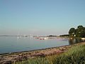
Coast at Bockholmwik in the municipality of Munkbrarup

The Flensburg outer fjord near Dollerup


- North bank

German-Danish border crossing Schusterkate (Skomagerhus) in Wassersleben

View of the Ox Islands at Annie's kiosk in Sønderhav

Flensburg Fjord and the promenade in Sønderhav
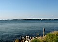
View from Schausende on the Holnis peninsula to the Danish coast

Stranderott / Stranderød fishing settlement ( Rinkenæs Sogn )


literature
- Christian Stolz: Gravitational mass movements on the Flensburg Fjord: An inventory of the extent and potential danger . In: Natural and regional studies . tape 123 , no. 1-2 , 2016, pp. 38-49 .
- Gert Uwe Detlefsen: Flensburg shipping - from paddle steamer to refrigerated ship . Christians & Reim Verlag, 1983, ISBN 3-87950-073-8 .
- Gert Uwe Detlefsen, Gerhard Moltsen, Alfred Schneider: From steam boats to catamarans. The history of Flensburger Fördeschiffahrt and all its subsidiaries . Hauschild Verlag , Bremen 2000, ISBN 3-89757-079-3 .
- Andreas Westphalen: Flensburg Fördeschifffahrt. 1866-1975. An era and its relics . HM Hausschild, Bremen 2005, ISBN 3-89757-237-0 .
- 360 degrees around the Flensburg Fjord 2005/2006 . Werkstatt Verlag, 2005, ISBN 3-9809622-2-9 .
Web links
Individual evidence
- ↑ Lüd vun de Flensburger Kant. Johannes Christiansen, Harrislee, expired… 1st edition. Skandia publishing house. NA Sørensen, Flensburg 1979, ISBN 3-88060-017-1 , Lüd ut de Norderstrat. Smugleri up de Flensburger För, p. 10–15 (Low German).
- ↑ Flensburg: Geomorphologist: Fjord instead of fjord is deceiving tourists. In: Flensburger Tageblatt . January 8, 2015; accessed on: May 1, 2018.
- ^ H. Liedtke: The Nordic glaciations in Central Europe. (= Research on German regional studies. 204). 1981, ISBN 3-88143-020-2 .
- ↑ K.-D. Schmidtke: The emergence of Schleswig-Holstein . Neumünster 1992, ISBN 3-529-05316-3 .
- ^ Flensburg Fjord Tourismus GmbH
- ↑ Beachclub: Førde Strand Flensburg celebrates its opening today. In: Flensburg Journal . April 30, 2015; accessed on: May 1, 2018.
- ^ K. Gripp: Geological history of Schleswig-Holstein . Neumünster 1964, DNB 451673344 .
- ↑ Christian Stolz: Gravitational mass movements on the Flensburg Fjord: An inventory of the extent and risk potential. In: Natural and regional studies. Volume 123, No. 1-3, 2016, pp. 38-49.
- ^ H. Liedtke, J. Marcinek : Physical geography of Germany . Gotha 2001.
- ^ Gert Uwe Detlefsen: Flensburg Fördeschiffe. Köhlers Verlagsgesellschaft, Herford 1977, ISBN 3-7822-0135-3 , p. 39.
- ↑ a b Andreas Westphalen: Flensburger Fördeschifffahrt. 1866-1975. An era and its relics . HM Hausschild, Bremen 2005, ISBN 3-89757-237-0 .
- ^ Regatta circus on tour of the Baltic Sea. In: Schleswiger Nachrichten . June 11, 2014, accessed June 16, 2015 .
- ↑ Sonwik, Flensburg. (= Opus. Volume 61). Stuttgart / London 2007, ISBN 978-3-932565-61-8 , p. 6.
- ↑ Aerial photo series Part II: Mürwik Naval School - The boom in the "muddy bay". In: Flensburger Tageblatt. July 17, 2012; accessed on: February 7, 2020.
- ↑ Light along the coast. In: Visitsonderborg. accessed on: February 7, 2020.
- ↑ An animal sensation in the Baltic Sea: Two humpback whales sighted in Flensburg Fjord for the first time. In: Flensburger Tageblatt. July 8, 2014, accessed August 21, 2014 .
- ↑ From Flensburg to the Baltic Sea: Bye Bye humpback whale - or is it? In: shz.de . July 18, 2014, accessed August 21, 2014 .
- ↑ a b Marine mammals in the Baltic Sea: Great fin whale swims in the Flensburg Fjord. In: shz.de . July 15, 2015, accessed July 17, 2015 .
- ↑ a b Whales, pumas, colorful birds: Curious animal encounters: What goes on in SH. In: shz.de. December 10, 2015, accessed December 11, 2015 .
- ↑ Bernd Philipsen: Westerholz: The whale drama on the beach. In: shz.de. March 16, 2011, accessed September 1, 2014 .
- ↑ Bernd Philipsen: 150 years of Flensburger Tageblatt: Thousands make a pilgrimage to the whale on the beach. In: Flensburger Tageblatt. May 12, 2015, accessed July 16, 2017 .
- ↑ Flensburg: Fin whale frightens rower on fjord. In: Flensburger Tageblatt. June 16, 2010, accessed September 1, 2014 .
- ↑ Fin whale in the fjord: Flensburg police publishes whale video. In: shz.de. July 16, 2015, accessed July 17, 2015 .
- ↑ Merle Bornemann: Ochseninseln: Seal visit in the Flensburg Fjord. In: Flensburger Tageblatt. June 7, 2013, accessed May 28, 2015 .
- ↑ Robbe feels at home in the fjord . In: Flensburger Tageblatt . September 8, 2015, p. 14 .
- ↑ Lars Kohstall: fascination porpoise: whale-watching on the Flensburg Fjord. In: Flensburger Tageblatt. June 27, 2018, accessed July 2, 2018 .
- ↑ "Delfie" and "Selfie" - the stars of the fjord. In: NDR.de . February 16, 2016. Retrieved February 29, 2016 .
- ^ Matthias Kirsch: Flensburg Fjord: Two dolphins on a discovery tour. In: Flensburger Tageblatt. March 21, 2016. Retrieved July 26, 2016 .
- ↑ See for example: FDP Flensburg, New Year's reception at the Marineschule Mürwik ( Memento from July 13, 2015 in the Internet Archive ) from January 30, 2013; Archive link checked on October 7, 2019.
- ↑ based on the book by Jörg Hillmann and Reinhard Scheiblich published in 2002
Coordinates: 54 ° 52 ' N , 9 ° 33' E