Egernsund Sogn
|
Egernsund Sogn ( German Ekensund ) |
||||
|
||||
| Basic data | ||||
|---|---|---|---|---|
| State : |
|
|||
| Region : | Syddanmark | |||
|
Municipality (since 2007) : |
Sønderborg | |||
| Coordinates : | 54 ° 54 ' N , 9 ° 37' E | |||
|
Population : (2020) |
1,513 | |||
| Postal code : | 6320 Egernsund | |||
| Website: | www.egernsund-kirke.dk | |||
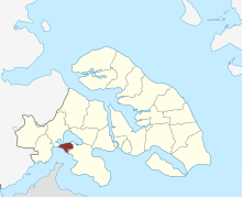
 Location of Egernsund Sogn in Sønderborg Municipality |
||||
Egernsund Sogn ( German Ekensund ; Sønderjysk or Sundevedsk : Echenson ) is a Danish parish ( Sogn in Danish ), which is located in southern Jutland on the north bank of the Flensburg Fjord on the Broager Land peninsula on Sundeved , about twelve kilometers west of Sønderborg . 1513 inhabitants live in the parish, 1450 of them in the city of Egernsund (as of January 1, 2020).
history
The name is derived from the sound of the same name , which connects Nybøl Nor ( German Nübeler Noor ) with the fjord. As early as 1922, the parish, which belonged to Harde Nybøl Herred in what was then Aabenraa-Sønderborg Amt , was merged with the neighboring municipality of Broager Sogn to form Broager Municipality , which survived the communal reform of 1970 undamaged because of its more than 6,000 inhabitants and was retained as a municipality in what was then Sønderjyllands Amt . In the course of the local government reform on January 1, 2007 , the Broager municipality was incorporated into the “new” Sønderborg municipality in the Syddanmark region .
Egernsund and its district of Rendbjerg were closely linked to brick production, as the combination of the necessary clay, navigable water and sufficient quantities of wood was available here. Of the many brickworks that were located on Nybøl Nor around 1800, only seven still exist today. Of the eight brickworks on neighboring Iller Strand, the last one closed in 1968. Since 1993, the Cathrinesminde Brickworks Museum has shown the history of bricks in this region from the Middle Ages to the present day.
In the late 19th century, artists such as Alexander Eckener , Jacob Nöbbe and Wilhelm Dreesen came together to form the Ekensund artists' colony .
The Egernsund Bridge , built in 1968, replaced the ferry between the Gråsten district of Alnor and Egernsund.
Culture and sights
Another attraction in addition to the Cathrinesminde brickworks museum is the Gendarmstien , which runs through Egernsund , a former control route on which Danish gendarmes patrolled the German-Danish border from 1920 to 1958.
Egernsund Church with surrounding buildings from the Flensburg Fjord , 2015
Web links
- Website of the municipality (Danish)
- Entry in the Sogne portal (Danish)
- City website (Danish)
- Ekensund artists' colony
Individual evidence
- ↑ a b Statistics Banks -> Befolkning og valg -> KM1: Befolkningen January 1st, April 1st, July 1st and October 1st, so og folkekirkemedlemsskab (Danish)
- ↑ Peter Dragsbo, Inge Adriansen, Kirsten Clausen, Hans Helmer Kristensen, Torben Vestergaard: I centrum ved gränsen - portræt af Sønderborg Municipality . Ed .: Museet på Sønderborg Slot & Historisk Samfund for Als og Sundeved (= Fra Als og Sundeved . Band 84 ). 2006, ISBN 87-87153-52-1 , ISSN 0085-0845 , E sproch - dansk og tysk, alsisk og sundevedsk, p. 128-131 (Danish).
- ↑ Statistics banks -> Befolkning og valg -> BY1: Folketal January 1st efter byområde, alder og køn (Danish)
- ^ Information from the Cathrinesminde Brickworks Museum
- ↑ Sætter focus på Egernsund-kunstnere. dr.dk, May 29, 2008, archived from the original on July 29, 2012 ; Retrieved October 26, 2009 (Danish).
- ^ Ekensund artists' colony. vimu.info, accessed December 23, 2016 .


