
Broager Land
| Broager Land | ||
| Geographical location | ||
|
||
| Coordinates | 54 ° 52 '53 " N , 9 ° 41' 18" E | |
| location | Sønderborg Kommune , Syddanmark Region , Denmark | |
| Waters 1 | Flensburg Fjord | |
| surface | 43.38 km² | |

Broager Land is a peninsula in North Schleswig ( Danish Sønderjylland ), Denmark . Broager Land as part of Broager Municipality has been part of Sønderborg Municipality since the municipal reform in 2007 . Broager Land has an area of 43.38 km² and a population of approx. 6400 people. The peninsula is completely enclosed by the Flensburg Outer Fjord , in a western part of Nybøl Nor , a northern branch (Noor) of the Flensburg Fjord, in the east of the Vemmingbund also a bay of the fjord.
The largest town in Broager Land is Broager ( German Broacker ) with the Broager Kirke, which can be seen from afar, and its distinctive twin towers.
South of Broager is the village of Iller , which is very famous for its brick production. Several brickworks were set up on the coast of the Iller Strand in the 18th century . Today's Cathrinesminde Brickworks Museum remains from the former eight brickworks on Iller Strand (1895) .
On Broager Land in the east is the street village of Skelde ( German Schelde ), which from 1910 to 1932 had a rail connection to the Vester Sottrup – Skelde railway . It was also known nationwide for the "Frøken Jensen" culture and meeting house.
At the place Brunsnæs ( German Brunsnis ) one discovered 1999 remnants of 550 years old hawthorn ( Danish hvidtjørn ).
The southernmost point of Broager Land is at Kragesand .

Broager Kirke, 2010

Cathrinesminde Brickwork Museum, 2004
old station skeleton with warehouse, 2016

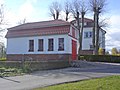
"Frøken Jensen" inn in Skelde, since 1888 (photo 2016)

Beach at Kragesand

Stensigmose cliff, in the east on the Sønderborg Bay, 2004


Web links
Individual evidence
- ↑ Brickworks on Iller Strand. Retrieved June 5, 2020 .
- ↑ Brunsnæstjørnen - Sønderborg. Dansk Dendrologisk Forening, accessed on June 5, 2020 (Danish).