
Holnis
| Map of the Holnis Peninsula |
|
|---|---|

|
|
| Area map of the Flensburg Fjord |
|

|
Holnis ( Danish : Holnæs ) is a peninsula in the Baltic Sea , which extends over a length of 6 km northeast of the town of Glücksburg in Schleswig-Holstein into the Flensburg Fjord and is part of Glücksburg. The peninsula is an important part of local tourism. On the peninsula there is a steep coast and a salt marsh with an important breeding colony for sea birds.
background
.jpg&filetimestamp=20161102201358&)


Originally, Holnis was an island that was connected to the mainland by a dam. The Big and Little Noor and Lake Neupugum were shallow bays. The area was finally connected to the mainland through dikes in 1929. A pumping station at the adjacent viewing end still drains the area that is below sea level.
The place name Holnis was first recorded in writing in 1463. There are different derivations for the first part of the name Hol (d) . A first derivation indicates that the Glücksburger and Munkbraruper areas ( including Rude ) were originally heavily forested. The name of Holnis also makes this clear, because “hold” means wood . In addition to this derivation, there is the presumption that the word component could mean “Erbbauer” (cf. Old Norse hǫlðr and Old Danish hald ). The word component could also go back to the Low German verb fetch or the Danish verb holde , each of which means to hold because ships stopped off the peninsula. The second part of the name -nis or dan. -næs describes a headland or peninsula in Danish.
Until it was incorporated into Glücksburg on October 1, 1938, Holnis was a municipality in the Flensburg-Land district . Efforts by Holnis residents to reverse the compulsory incorporation after the Second World War failed. Nevertheless, in 1949 the Glücksburg town hall decided to set up a commission for the municipalities of Holnis and Bockholm, which were forcibly incorporated in 1938. The commission, which was allowed to contribute proposals for the promotion of the areas Holnis and Bockholm in the town hall, existed until 1968.
On the southern edge of Holnis is the small town Drei (Danish: Draget ). The bathing and spa beach at Drei is one of the most beautiful beaches on the Flensburg Fjord. In contrast to the Glücksburg spa beach, it is not on the inner fjord, but on the Flensburg outer fjord. This opens to the free Baltic Sea with a constant circulation and consequently a permanent water exchange, which is much lower in the inner fjord. This often results in significantly better water quality in the outer fjord with a higher salt and oxygen content, while the inner fjord mostly consists of almost brackish water . Further south of Drei are the neighboring parts of Glücksburg, Bockholm and Iskiersand. (The neighboring village of Munkbrarup has an adjacent district of the same name called Iskiersand.) On the southwestern edge of Holnis, on the inner fjord, there is also the village of Schausende (from Danish Skovsende , roughly "forest end") with a small marina and a lighthouse.
The steep coast between the district of Schausende and the tip of the peninsula is a result of the tectonic deformations caused by the last ice age , which is responsible for the development of the landscape of the entire east coast of northern Schleswig-Holstein. The terminal moraines that formed in the last Ice Age reach here as far as the Baltic Sea coast and have been formed into a steep coast by the surf of thousands of years. Since the cliffs have been left in their original state to this day, from time to time some material breaks off from the undercut areas and remains on the surf platform. It can happen that even larger parts slide off as clods because the moraines are criss-crossed by numerous layers of clay . Since the rainwater collects on these impermeable clay layers, water from numerous small springs emerges on the steep walls .
natural reserve
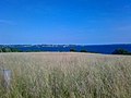
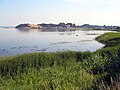
Parts of the peninsula are designated as a nature reserve: The little Noor, as well as the cliffs, the salt marsh, the north beach and the areas on the dike from Schausende are under nature protection. With the exception of the north beach, they are not allowed to be entered, as they offer valuable resting and breeding areas for sea birds. Some of the protected meadows are extensively grazed by Galloway cattle and Scottish highland cattle. This creates a savannah-like landscape with a high level of biodiversity. In 2002 a small breakthrough through the dike was dared and the little Noor was reconnected to the Flensburg Fjord. A very species-rich biotope was created here in a short time.
Since Holnis is a popular destination, the large number of visitors results in some nature conservation problems. The requirement to stay on the paths, not to step on the cliffs and to keep dogs on a leash is sometimes not observed. There is also sometimes careless garbage disposal. Especially on the weekends, the north beach is popular as a bathing beach in summer, as it is not subject to tourist tax. The area is monitored by employees of Nabu SH . In the info hut you can find out more about the protected area.
Sightseeing and tourism
Because of the extraordinary landscape and diverse fauna , Holnis is a popular holiday destination. Holiday apartments, guest rooms, restaurants and the Ostseecamp campsite on the eastern beach at Drei with an attached long sandy beach offer tourists overnight accommodation. Various water sports and leisure activities are offered on this spa beach.
In addition to nature, the peninsula is home to some sights, such as the Holnis lighthouse . A little south of the Holnis pier on the Holnisser Fährstraße is the Danish memorial, which commemorates a sea-land battle that took place here in April 1848 and is called a soldier's grave . Two Danish ships, the “Najaden” and the “Hekla”, were involved in this battle, and the quartermaster of the “Hekla”, Niels T. Børgesen, was fatally wounded. He was buried at this point. Another grave is the seaman's grave from 1839, which is located on the north bank of the peninsula. It is reminiscent of a Flensburg sailor who died of cholera on his ship and was buried on the bank. The church of Broager can also be mentioned as a sight . It can only be seen in the distance on the other side of the fjord, but the legend of the twin towers of Broager is very well known here too, and the distant church is often shown in this context. The ox islands with the legend of their creation are also among the sights visible from Holnis.
In the west of the peninsula, near Schausende, water sports enthusiasts will find Club Nautic eV , a guarded and very protected sports boat harbor with 169 berths, which offers guest berths and a restaurant. The 18-hole Förde-Golf-Club Glücksburg, founded in 1972, is located in the south-east near Bockholm.
The legend of Doctor Faust and his ferryman Nis
A local legend of unknown origin explains the name Holnis as follows: Doctor Faust , who was sometimes also referred to as the devil in the area, once drove across the fjord with a Nis who was in his service. But, of course, the good Lord was not well disposed towards Doctor Faust and drove him along. So the two came into a strong wind, and the glass ship with which the devilish doctor explored the depths and shallows of the sea and made sea charts threatened to capsize at the entrance to the Flensburg harbor . Faust, a gigantic figure compared to little Nis, feared doom. So the “old doctor” shouted “Get Nis!” Because the Nis was supposed to haul in the sails and bring the ship to a halt, which he succeeded in doing. So Doctor Faust escaped divine punishment for the time being, and Nis could breathe a sigh of relief. Since then, so the legend goes, the peninsula there has been called Holnis.

Holnis cliff natural monument
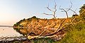
Holnis cliff

Holnisspitze, former ferry terminal
Holnisspitze, view towards Brunsnæs / Denmark
West side with cliffs

The steep coast seen from Denmark

Quartermaster Niels T. Børgesen burial site

Peter Thomson burial site


.jpg&filetimestamp=20161102201358)
literature
- Chronicle Bockholm, Drei, Holnis, Kobbellück, Schausende . Written by a team of authors led by Telsche Henningsen. Husum Druck- und Verlagsgesellschaft, Husum 2019, ISBN 978-3-89876-966-2 .
Web links
- Nature reserve and nature information peninsula Holnis - Northeasternmost point of Germany. NABU Schleswig-Holstein, accessed on June 18, 2015 .
- Mira Nagar: Around Holnis: a peninsula with two faces. In: shz.de. Schleswig-Holsteinischer Zeitungsverlag , February 18, 2014, accessed on June 18, 2015 .
- Beach test Flensburg-Glücksburg: Holnis: Average beach with a premium location. In: Flensburger Tageblatt . July 29, 2014, accessed June 18, 2015 .
Individual evidence
- ↑ a b LG Flensburg: "sandwig.de" ( Memento of the original from April 14, 2015 in the Internet Archive ) Info: The archive link was inserted automatically and has not yet been checked. Please check the original and archive link according to the instructions and then remove this notice. , dated: January 8, 2002; Retrieved on: February 28, 2017
- ↑ Johannes Kok: Det danske folkesprog i Sønderjylland , 2nd volume, København 1867, p. 185
- ↑ Hans Nicolai Andreas Jensen : fishing, historical and topographically described , Kiel 1991, p. 140
- ^ The German vocabulary from 1600 to today. Heroism , accessed: February 1, 2019]
- ↑ Wolfgang Laur: Historisches Ortsnamelexikon von Schleswig-Holstein , 2nd edition, Neumünster 1992, p. 344
- ↑ Wolfgang Laur: Historisches Ortsnamelexikon von Schleswig-Holstein , 2nd edition, Neumünster 1992, p. 344
- ↑ Chronicle Bockholm, Drei, Holnis, Kobbellück, Schausende . Written by a team of authors led by Telsche Henningsen, Husum 2019, p. 18 ff.
- ↑ See archive link ( Memento of the original from February 20, 2015 in the Internet Archive ) Info: The archive link was automatically inserted and not yet checked. Please check the original and archive link according to the instructions and then remove this notice. ; Retrieved on: May 22, 2015
- ↑ a b Fördesteig , page 18; Retrieved on: March 17, 2017
- ↑ Apparently Low German for “Halt Nis!” Cf. Johannes Sass : Der neue Sass - Low German Dictionary - Low German - High German, High German - Low German. 2nd edition, Wachholtz Verlag, Neumünster 2002, entry: keep
- ↑ Cf. Gundula Hubrich-Messow: Sagen und Märchen aus Flensburg , Husum 1992, pages 28 and 33; as also: Gundula Hubrich-Messow: Legends and fairy tales from fishing , Husum 1987, page 74.
Coordinates: 54 ° 52 ′ 0 ″ N , 9 ° 36 ′ 0 ″ E