Coyer Point
| Coyer Point | ||
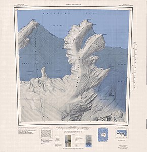
 Topographic map of the Martin Peninsula with Coyer Point (center right) |
||
| Geographical location | ||
|
|
||
| Coordinates | 74 ° 24 ′ S , 113 ° 13 ′ W | |
| location | Marie Byrd Land , West Antarctica | |
| coast | Walgreen coast | |
| Waters | Dotson Ice Shelf | |
The Coyer Point is an ice-covered headland at the Walgreen Coast of the West Antarctic Marie Byrd lands . It is located on the southeast coast of the Martin Peninsula . It represents the northern end of an icy peninsula that penetrates 37 km south-southeast of Jacobsen Head into the Dotson Ice Shelf .
The United States Geological Survey mapped the headland using the United States Navy's own surveys and aerial photographs from 1959 to 1967 and Landsat surveys between 1972 and 1973. The Advisory Committee on Antarctic Names named it after Lieutenant Ann E. Coyer, who became the first woman in the US Navy to participate in Operation Deep Freeze in 1974.
Web links
- Coyer Point in the Geographic Names Information System of the United States Geological Survey (English)
- Coyer Point on geographic.org (English)
