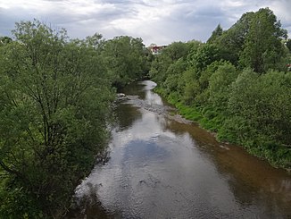
Czarna Orawa
|
Czarna Orawa Čierna Orava |
||
|
Jabłonka |
||
| Data | ||
| location | Lesser Poland Voivodeship , Poland | |
| River system | Danube | |
| Drain over | Orava → Waag → Danube → Black Sea | |
| origin |
Bukowinski Wierch 49 ° 31 '12 " N , 19 ° 48' 57" O |
|
| muzzle |
Arwa reservoir near Jabłonka Coordinates: 49 ° 28 '27 " N , 19 ° 37' 52" E 49 ° 28 '27 " N , 19 ° 37' 52" E |
|
| Mouth height |
912 m npm
|
|
| length | 29 km | |
| Communities | Raba Wyżna , Jabłonka | |
The Czarna Orawa (German Black Arwa , Slovak Čierna Orava ) is a river in the Polish Voivodeship Lesser Poland in the Saybuscher Beskids , specifically in the Arwa-Podhale Beskids mountain range . It is one of the two source rivers of the Orava ; the other source river, the Biela Orava , lies entirely in Slovakia .
Its length is 29 kilometers. It rises on the slopes of the Bukowiński Wierch and Żeleźnica mountains in the Powiat Nowotarski district and flows into the Kotlina Orawsko-Nowotarska basin . It flows into the Orava reservoir just before the border with Slovakia. Before the reservoir was built, the river was 19 km longer and merged with the Biela Orava to form the Orava at Ústie nad Oravou (no longer existing today). The Czarna Orawa is one of the few rivers in Poland that lies south of the main European watershed and drains into the Black Sea. In its lower part it flows through the 184 hectare nature reserve Czarna Orawa (Natura 2000).
