Orava (river)
| Orava | ||
| Data | ||
| location | Žilinský kraj , Slovakia | |
| River system | Danube | |
| Drain over | Waag → Danube → Black Sea | |
| origin |
Orava Reservoir 49 ° 22 ′ 31 ″ N , 19 ° 33 ′ 25 ″ E |
|
| muzzle |
Waag bei Kraľovany Coordinates: 49 ° 9 ′ 13 ″ N , 19 ° 8 ′ 25 ″ E 49 ° 9 ′ 13 ″ N , 19 ° 8 ′ 25 ″ E |
|
| Mouth height |
430 m nm
|
|
| length | 62 km | |
| Catchment area | 1,191.8 km² | |
| Drain |
MQ |
33.1 m³ / s |
| Left tributaries | Oravica, Studený potok | |
| Right tributaries | Zázrivka | |
| Reservoirs flowed through | Orava, Tvrdošín | |
| Medium-sized cities | Dolny Kubin | |
| Small towns | Tvrdošín | |
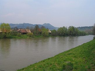
The Orava (German Arwa ) is a river in north-western Slovakia , after which the Orava region was named.

Its length is 62 kilometers and it is fed today from the water of the Orava reservoir and flows into the Waag ( Váh in Slovak ) at Kraľovany . The Orava has two source rivers above the Orava reservoir. One is the approx. 30 km long Czarna Orawa ( Čierna Orava in Slovak ), which rises in the Polish Saybuscher Beskids and flows into the Orava reservoir from the northeast, just before the state border between Poland and Slovakia. The second is the approx. 35 km long Biela Orava , which has its source in the Slovakian Oravská Magura and flows into the reservoir from the northeast, near Námestovo . Before the damming of the lake, the confluence of the Czarna Orawa and Biela Orava at the now submerged place Ústie nad Oravou was considered the beginning of the Orava.
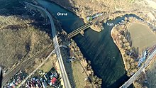
After the outflow from the dam of the Orava reservoir, the river behind Štefanov nad Oravou reaches the Tvrdošín reservoir and shortly afterwards the town of Tvrdošín itself, where it receives the Oravica on the left . In the further course to Dolný Kubín the Orava flows mainly in a south-westerly direction in a winding course between the mountains Oravská Magura north and the mountainous region Skorušinské vrchy south of the river. The Arwaburg lies on a cliff near Oravský Podzámok . After Dolný Kubín, the river corrects its direction slightly to the west and before Kraľovany makes a bend to the south, before it comes to Kraľovany, below the massif of Mount Šíp ( 1170 m nm ) in the Little Fatra and a few meters downstream of the bridge on the railway line Košice – Žilina , into which the Váh flows.
The river is almost completely accompanied by the Kraľovany – Suchá Hora railway line , 1st order road 70 and partly by 1st order road 59 .
See also
Web links
- Predbežné hodotenie povodňového rizika v čiastkovom povodí Váhu (PDF, 3.7 MB, Slovak) (p. 67)

