Village view
| Village view | ||
|---|---|---|
|
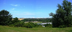
View from the village view to Berlin |
||
| height | 85.6 m above sea level NHN | |
| location | Rudow , Berlin ( Germany ) | |
| Coordinates | 52 ° 23 '50 " N , 13 ° 28' 53" E | |
|
|
||
| Type | Mountain of rubble | |
The Dörferblick is an artificial elevation in the Berlin district of Rudow and at 85.6 m above sea level. NHN height one of the highest elevations in Berlin .
The Dörferblick was created in the post-war period in 1958 as a mountain of rubble . After the Berlin blockade and the construction of the Berlin Wall , its area - located on the extreme southeastern edge of West Berlin, right next to the former Wall - was also used as one of the inner-city rubbish dumps in West Berlin, as the landfills in the Brandenburg area are no longer accessible were. The northern boundary of the area is formed by the former railway line of the outer freight ring , which formerly led from Bohnsdorf to Lichtenrade and ran a little over Berlin.
In the 1970s it was redesigned as a local recreation area . This turned out to be difficult because the biochemical processes inside the mountain were not yet complete. The treeless summit offered a good view over the Berlin Wall of the surroundings, in particular of the East Berlin district of Bohnsdorf and the neighboring Brandenburg villages of Schönefeld , Waßmannsdorf and Großziethen , which is why the survey was initially named "Three-Villages View" which was later changed to "Dörferblick".
Web links
- Panoramablick vom Dörferblick on rudow.de , accessed on July 11, 2011
Individual evidence
- ↑ a b Digital topographic map 1: 10,000 (DTK10) , on stadt-berlin.de
- ↑ Rudow in map from 1947 ( memento from October 5, 2014 in the web archive archive.today ), Schropp's Großer Berliner Verkehrsplan , from alt-berlin.info
- ↑ Route 5 Rudow - Dörferblick , accessed on July 11, 2011, from gartenkulturpfad-neukölln.de


