
Dalsnibba
| Dalsnibba | ||
|---|---|---|
 View of Geiranger and the Dalsnibba (center) from the north-west |
||
| height | 1476 moh. | |
| location | Stranda , Møre og Romsdal , Norway | |
| Mountains | Scandinavian mountains | |
| Dominance | 1.55 km → west flank of Rundegga | |
| Notch height | 166 m ↓ ridge between Dalsnibba and Rundegga | |
| Coordinates | 62 ° 4 '43 " N , 7 ° 17' 35" E | |
| Topo map | 1319 III Tafjord | |
|
||
| Development | Toll road, summit restaurant | |

The Dalsnibba is a 1476 moh. high mountain peak south of the Norwegian town of Geiranger , in the municipality of Stranda , Møre og Romsdal province . The mountain is accessible via the Nibbevegen road, which leads from Djupvasshytta to the summit, and is popular because of the view of the Geirangerfjord, 7 kilometers away . Due to its height, it is often still covered with snow even in summer. The Dalsnibba is east of the 1038 moh. high Dalsnibba pass , which is crossed by the Geiranger road between Geiranger and Lom . There is the Djupvasshytta mountain hut . Right next to it shimmers blue-green, but often also covered with snow and ice, the lake Djupvatnet ( 1016 moh. ).
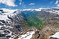
Panoramic view from Dalsnibba into the Geirangertal
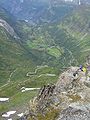
View from Dalsnibba to Geiranger


Web links
Individual evidence
- ↑ a b Topographic map of Norway (section with Dalsnibba) , ut.no, accessed on January 26, 2015
- ↑ Store norske leksikon : Dalsnibba , accessed on January 26, 2015 (Norwegian)