
Nibbevegen
| Nibbevegen (toll road in Norway) | |||||||||||||||||||||
|---|---|---|---|---|---|---|---|---|---|---|---|---|---|---|---|---|---|---|---|---|---|
 |
|||||||||||||||||||||
| Basic data | |||||||||||||||||||||
|
|||||||||||||||||||||
|
|||||||||||||||||||||
 The Nibbevegen in June 2012 (lower section of the mountain slope) |
|||||||||||||||||||||

The Nibbevegen (also Nibbevei ) is a toll private road in the Norwegian municipality of Stranda , in the province of Møre og Romsdal . It begins as a junction from Geirangerstraße on Djupvatnet , at about 1035 moh. The street ends at 1476 moh. on the summit of Dalsnibba . It is the highest point in Norway that can be reached by road. The road is closed in winter and is usually open from June to October. The Geirangerfjord and the very popular tourist destination Geiranger are located about 8.5 km (as the crow flies) northwest of the start of the road.
Course and description
The road branches off from Geirangerstrasse at the Djupvasshytta mountain hut, located on Djupvatnet . About 175 m further on is the toll station on the road, where a fee for using the road must be paid for all types of motor vehicle . After a right-hand bend, there is a long, straight ascent of just under 1.2 km to the Dalsnibba massif, where an altitude difference of around 110 m is overcome. The next ascent of the road runs in 10 hairpin bends of approx. 1160 moh. to around 1325 moh. The last section of the route leads with a relatively low gradient for the last 1.5 km directly at the edge of the high plateau in a long right curve around two secondary peaks of Dalsnibba. The road ends in a large turning area with a parking lot on the summit of Dalsnibba, at about 1476 moh. This is where the service building, built in 2004 in a modern style, is located with a souvenir shop , panorama café and exhibition about the road construction of the Nibbevegen.
history
The road was built by hand from 1936 to 1939 as a gravel road without any significant protection. Due to the Second World War , there was no significant volume of tourist traffic on the road until 1946. Unlike today, in the years that followed, the road was not used with private cars or buses, but rather with cars specially designed for the terrain.
In order to cope with the increasing volume of traffic and to increase safety, the previously unpaved roadway was paved and widened and secured in many places at the end of the 2000s .
photos

A bus on the descent from Dalsnibba on the Nibbevegen
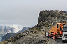
Road construction work on the Nibbevegen in August 2011, behind the Dalsnibba

The service building built in 2004 with a panoramic front


literature
- Leif Vinje (eds.), Stein Ugelvik Larsen, Jan Rune Holmevik: Nibbevegen Geiranger 50 år 1939–1989 , Geiranger skysslag, Stranda 1989 (62 pages, Nynorsk)
Web links
Individual evidence
- ↑ a b c d e f Ulrich Quack, Gerhard Austrup: Norway - Tips for individual explorers . Iwanowski´s travel book publisher, Dormagen 2009, ISBN 978-3-933041-41-8 , p. 300 ( limited preview in Google Book Search).
- ↑ a b c d e f Topographic map of Norway (excerpt with Nibbevegen) , ut.no, accessed on December 23, 2015
- ↑ Dalsnibba - Nibbevegen ( Memento of the original dated December 23, 2015 in the Internet Archive ) Info: The archive link has been inserted automatically and has not yet been checked. Please check the original and archive link according to the instructions and then remove this notice. , visitalesund-geiranger.com, accessed December 23, 2015
- ↑ Dalsnibba ( Memento of the original from December 24, 2015 in the Internet Archive ) Info: The archive link was inserted automatically and has not yet been checked. Please check the original and archive link according to the instructions and then remove this notice. , poi-norwegen.de, accessed on December 23, 2015
- ↑ Dalsnibba - History , dalsnibba.no, accessed on December 23, 2015 (English)
- ↑ Dalsnibba , skandinavischer-sommer.de, accessed on December 23, 2015