
Dammaschwiese

The Dammaschwiese in Celle is a green area as well as an excursion , recreation and leisure area in the city. The meadow can be flooded and in winter is used temporarily as a natural ice rink , which is sometimes illuminated with floodlights until 9 p.m. The so after the end of the growing season usable area for skaters includes approximately 1.7 hectares and has a water depth of an average of 60 centimeters .
history
In the Middle Ages , Duke Otto der Strenge left the Dammaschwiese area to the citizens of Celle, presumably for use . Around eight decades later, Duke Magnus donated the area to the city in 1372 as "Danne", as pasture for pigs .
It was not until the time of the Kingdom of Hanover that the city of Celle had the area drained and converted into a meadow in 1848.

High water mark for the status on February 12, 1946 on the banks of the Dammaschwiese, view over the Aller near the Pfennig Bridge to the Fritzenwiese
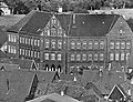
The former building of the Hermann-Billung-Gymnasium , in the background the Dammaschwiese , before 1971


See also
literature
- Rolf-Dieter Diehl: Stories and anecdotes from the old Celle and its surroundings , Volume 3: At two at the Dammaschwiese , 1st edition, Gudensberg: Wartberg-Verlag, 2008, ISBN 978-3-8313-1900-8 ; Table of contents (as PDF document )
Web links
Individual evidence
- ↑ a b c RWLE Möller : Dammaschwiese. In: RWLE Möller: Celle-Lexikon . From Abbensen to between. Lax, Hildesheim 1987, ISBN 3-7848-4039-6 , p. 46
- ↑ Gunther Meinrenken: Dammaschwiese is being prepared for skid-steers ( memento of the original from January 11, 2016 in the Internet Archive ) Info: The archive link was inserted automatically and has not yet been checked. Please check the original and archive link according to the instructions and then remove this notice. , in: Cellesche Zeitung of November 26, 2010, last accessed on January 11, 2016
Coordinates: 52 ° 37 '35 " N , 10 ° 5' 34.1" E