
Dhalai (District)
| Dhalai district | |
|---|---|

|
|
| State | Tripura |
| Administrative headquarters : | Ambassa |
| Area : | 2312.29 km² |
| Residents : | 378,230 (2011) |
| Population density : | 164 inhabitants / km² |
| Website : | official website |
The district of Dhalai is a district in the Indian state of Tripura . The administrative seat is the city of Ambassa .
geography
The Dhalai district is located in the eastern half of Tripura on the border with Bangladesh . The area of the district is 2312 square kilometers. Neighboring districts are Unakoti and North Tripura districts in the east and Gomati and Khowai districts in the west. In the south and north the district borders on India's neighboring state Bangladesh.
history
The district was created on April 15, 1995 in its current form from parts of the then districts of North Tripura and South Tripura.
population
According to the 2011 census, the Dhalai district has 378,230 inhabitants. With 164 inhabitants per square kilometer, the district is densely populated. Of the 378,230 residents, 337,731 people (89.29 percent) live in rural communities and 40,499 people in urban areas.
The district of Dhalai district is the only district of Tripura that is mostly populated by members of the "tribal population" ( scheduled tribes ). Among them (2011) were 210,608 people (55.68 percent of the district population). In 2011, 61,688 people (16.31 percent of the district's population) belonged to the Dalit ( scheduled castes ).
Population development
Tripura was divided into three districts in 1970 - North Tripura, South Tripura and West Tripura. In 1995, the Dhalai District was formed from parts of the North Tripura and South Tripura districts. As everywhere in India, the population in the Dhalai district has been growing rapidly for decades. The 2001 Indian census found a population of 310,598 people. The increase in the years 2001–2011 was more than 16 percent (16.23%). In these ten years the population increased by around 68,000 people. The population development from 1901 to 2011 was as follows:

Significant places
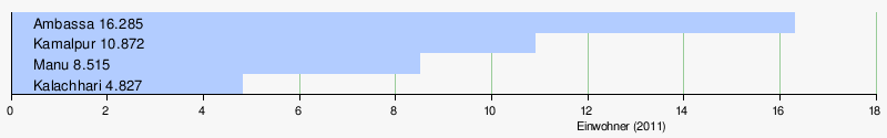
There are only two urban settlements in the district with the district capital, Ambassa and Kamalpur. Statistically, however, Manu and Kalachhari are also census towns.
District population by gender
Of the 378,230 residents, 194,544 (51.44 percent) were male and 183,686 female. This is typical of India, where there is a marked increase in men. Within the state of Tripura, the district of Dhalai is the district with the lowest percentage of women with 944 women per 1000 men.
District population by language
A large minority - 35.08 percent - of the total population of Dhalai District speaks Bengali. Various Tripura languages are spoken by a total of 157,238 people (41.57 percent). These include Kokborok (144,478), Reang (8,635) and Tripuri (3,998). With Chakma with 34,323 (9.07 percent) there is another language that is spoken by more than 10,000 people. Another important language is Halam with 5,866 speakers (1.55 percent). Hindi is only spoken by a small minority of immigrants. Of the 7,808 Hindi-speaking residents, 4,385 people live in the RD Block Salema.
| year | Kokborok | Bengali | Chakma | Reang | Hindi | Halam | Other languages | Total | ||||||||
|---|---|---|---|---|---|---|---|---|---|---|---|---|---|---|---|---|
| number | % | number | % | number | % | number | % | number | % | number | % | number | % | number | % | |
| 2011 | 144,478 | 38.20 | 132,667 | 35.08 | 34,323 | 9.07 | 8,635 | 2.28 | 7,808 | 2.06 | 5,866 | 1.55 | 44,453 | 11.75 | 378.230 | 100.00% |
| Source: 2011 census result | ||||||||||||||||
Population of the district by confession
The majority of the residents profess Hinduism. The majority of Bengali and Hindi speakers belong to their appendix. A minority among the Bengalis profess Islam. The Buddhists are found almost entirely under the Chakma. The majority of them live in the RD blocks Dumburnagar, Chhamanu and Manu, where they make up 14,530, 10,690 and 10,452 members respectively, 24.46, 31.84 and 12.41 percent of the respective population. The Christian population is strongly represented everywhere with the exception of the RD block Chhamanu. The majority of them live in the RD Blocks Ambassa and Manu, where they count more than 7000 each. Christians are particularly well represented among the “scheduled tribes”. Most Muslims live mainly in the RD Blocks Salema, where they make up 5.09 percent of the population with 6,072 members. Buddhists, Christians and Muslims form locally and regionally significant religious minorities. The following table shows the exact religious composition of the population:
| year | Buddhists | Christians | Hindus | Jainas | Muslims | Sikhs | Other | not specified | Total | |||||||||
|---|---|---|---|---|---|---|---|---|---|---|---|---|---|---|---|---|---|---|
| number | % | number | % | number | % | number | % | number | % | number | % | number | % | number | % | number | % | |
| 2011 | 39,120 | 10.34 | 22,940 | 6.06 | 307.120 | 81.20 | 85 | 0.02 | 8,256 | 2.18 | 175 | 0.05 | 206 | 0.05 | 328 | 0.09 | 378.230 | 100.00% |
| Source: 2011 census result | ||||||||||||||||||
education
The goal of full literacy is within reach. Of the 322,219 people aged seven and over, 276,217 (85.72 percent) can read and write. Literacy is well above the Indian average. But there are clear differences in literacy between the sexes and a city / country ditch. While 91.31 percent of the male population can read and write, it is only 79.79 percent of the female population. More than 97 percent of the male population in cities is literate. It is only just under 78 percent of rural women. The following table provides an overview of the relationships:
| Literacy in the Dhalai district | ||||||
| unit | 2011 census | |||||
| number | proportion of | |||||
| TOTAL | 276.217 | 85.72% | ||||
| Men | 151,643 | 91.31% | ||||
| Women | 124,574 | 79.79% | ||||
| TOTAL CITY | 34,399 | 95.40% | ||||
| City men | 18.003 | 97.28% | ||||
| City women | 16,396 | 93.41% | ||||
| TOTAL COUNTRY | 241.818 | 84.50% | ||||
| Country men | 133,640 | 90.56% | ||||
| Country women | 108.178 | 78.06% | ||||
| Source: 2011 census result | ||||||
administration
With Ambassa, Gandachera, Kamalpur and Longtarai Valley, the district has four sub-divisions (sub-districts), which in turn are divided into the eight RD blocks Ambassa and Ganganagar (both sub-division Ambassa), Dumburnagar and Raishyabari (both sub-division Gandachera), Durga Chawmuhani and Salema (both sub-division Kamalpur) as well as Chhamanu and Manu (both sub-division Longtarai Valley) are divided.
Individual evidence
- ↑ Information about the district
- ↑ District Census Handbook Dhalai
- ↑ Tripura, Decadal Variation of Population
Web links
Dhalai | Gomati | Khowai | North Tripura | Sipahijala | South Tripura | Unakoti | West Tripura
Coordinates: 24 ° 12 ′ 0 ″ N , 92 ° 0 ′ 36 ″ E