West Tripura
| West Tripura District | |
|---|---|

|
|
| State | Tripura |
| Administrative headquarters : | Agartala |
| Area : | 942.55 km² |
| Residents : | 918,200 (2011) |
| Population density : | 974 inhabitants / km² |
| Website : | official website |
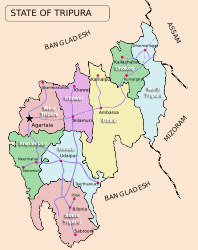
The West Tripura District is a district in the Indian state of Tripura . The administrative seat is the city of Agartala .
geography
The West Tripura district is located in northwest Tripura on the border with Bangladesh . The area of the district is 943 square kilometers. Neighboring districts are the Khowai districts in the east and Sipahijala in the south. In the north and west, the district borders on India's neighboring state, Bangladesh.
history
The district was created with the creation of the administrative areas of Tripura on September 1, 1970. In 2012, its area decreased with the establishment of the districts of Khowai and Sipahijala .
population
According to the 2011 census, West Tripura district has 918,200 inhabitants. With 974 inhabitants per square kilometer, the district is very densely populated. Of the 918,200 residents, 329,466 people (35.88 percent) lived in rural communities and 588,734 people in urban areas. West Tripura District is the only district of Tripura with a predominantly urban population.
The district of West Tripura is one of the areas of India in which numerous members of the "tribal population" ( scheduled tribes ) settle. They included (2011) 176,596 people (19.23 percent of the district population). In 2011, the Dalit ( scheduled castes ) numbered 192,475 people (20.96 percent of the district's population).
Population development
West Tripura District in the boundaries until 2012
Tripura was divided into three districts in 1970 - North Tripura, South Tripura and West Tripura. The population development from 1901 to 2011 in the limits before 2012 was as follows:

Today's limits
As everywhere in India, the population in the West Tripura district has been growing rapidly for decades. The 2001 Indian census found a population of 812,839 people. The increase between 2001 and 2011 was around 13 percent (12.96%). In these ten years the population increased by more than 105,000 people.
Significant places
There are two urban settlements in the district with the district capital Agartala and Ranirbazar. In addition, Anandanagar, Bankimnagar, Briddhanagar, Charipara, Dukli, Gandhigram, Madhuban, Madhupur, Narsingarh, Radhakishorenagar, Singarbil, Taranagar and Uttar Champamura count as cities (so-called census towns).

District population by gender
Of the 918,200 residents, 466,152 (50.77 percent) were male and 452,048 female. This is atypical for India, where there is usually a significantly larger number of men.
District population by language
A clear majority of over 76 percent of the population speaks Bengali as their mother tongue. In the cities it is even over 90 percent. In the RD blocks Dukli, Jirania and Mohanpur, the Bengali-speaking residents are in the majority with proportions between 60.7 percent (in Jirania) and 92.7 percent (in Dukli). In the RD blocks Hezamara (32,564 of the 35,628 inhabitants) and Mandai (40,905 of the 44,670 inhabitants) Kokborok clearly predominates. Kokborok is also the language of a large minority in the RD blocks Jirania and Mohanpur. The majority of the Hindi-speaking residents live in the city of Agartala and the RD Blocks Jirania and Mohanpur. The following table shows the language relationships:
| year | Bengali | Kokborok | Hindi | Odia | Manipuri | Bhojpuri | Other languages | Total | ||||||||
|---|---|---|---|---|---|---|---|---|---|---|---|---|---|---|---|---|
| number | % | number | % | number | % | number | % | number | % | number | % | number | % | number | % | |
| 2011 | 699.039 | 76.13 | 162.122 | 17.66 | 18,767 | 2.04 | 7501 | 0.82 | 6568 | 0.72 | 3815 | 0.42 | 20,388 | 2.22 | 918.200 | 100.00% |
| Source: 2011 census result | ||||||||||||||||
Population of the district by confession
The majority of the residents profess Hinduism. The majority of Bengali and Hindi speakers belong to their appendix. A small minority among the Bengalis profess Islam. The majority of the Muslims live in the city of Agartala and in the RD blocks Dukli and Jirania. The majority of Christians belong to the “scheduled tribes” (tribal population) and the Dalit (also “untouchables”, casteless). Many of them live in all areas of the district with the exception of the city of Ranirbazar and the RD Block Dukli. In the Hezamara and Mandai RD blocks, more than 10 percent of the population is Christian. The few Buddhists limit themselves almost entirely to the language groups of the Chakma. The following table shows the exact religious composition of the population:
| year | Buddhists | Christians | Hindus | Jainas | Muslims | Sikhs | Other | not specified | Total | |||||||||
|---|---|---|---|---|---|---|---|---|---|---|---|---|---|---|---|---|---|---|
| number | % | number | % | number | % | number | % | number | % | number | % | number | % | number | % | number | % | |
| 2011 | 1388 | 0.15 | 30,554 | 3.32 | 851.203 | 92.70 | 274 | 0.03 | 32,420 | 3.53 | 258 | 0.03 | 122 | 0.01 | 1981 | 0.22 | 918.200 | 100.00% |
| Source: 2011 census result | ||||||||||||||||||
education
The goal of full literacy is within reach. Of the 825,122 people aged seven and over, 751,396 (91.06 percent) can read and write. Literacy is well above the Indian average.
administration
With Jirania, Mohanpur and Sadar, the new district has three sub-divisions (subdistricts), which are divided into the nine RD blocks Bamutia, Belbari, Dukli, Hezamara, Jirania, Lefunga, Mandai, Mohanpur and Old Agartala.
Individual evidence
Web links
Coordinates: 23 ° 33 ′ 0 ″ N , 91 ° 18 ′ 0 ″ E