Dholpur (State)
| Dholpur | |||||
| approx. 700-1949 | |||||
|
|||||
| Capital | Dholpur | ||||
| Form of government | Princely state (15 rounds salute) | ||||
| surface | 3048 km² | ||||
| population | 29,000 (1941) | ||||
| founding | about 700 | ||||
| resolution | April 7, 1949 | ||||
| State religion: Hinduism Dynasty: Bamraolia Jat |
|||||
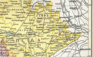
| Princely state of Dholpur on a map from The Imperial Gazetteer of India (1907–1909) | |||||
Dholpur ( Hindi : धौलपुर , Dhaulpur ) was one of the princely states of the Rajputs in today's Rajasthan ( British India ), named after the capital of the same name .
The ancestors of the Bamraolia Jat dynasty, which has existed since around 700, founded Dholpur in 1004 and the princely state of Gohad in 1505 . 1740–56 Gohad was occupied by Gwalior , 1761–75 Dholpur by Bharatpur . Gwalior annexed Dholpur in 1782 and Gohad in 1783, but had to give up both areas again in 1804/05 in the course of the war between the British East India Company and the Marathas . In 1806 the Rana Khirat Singh united Dholpur and Gohad; he assumed the title of Maharajadhiraja Sri Sawai Maharaj Rana. Due to a treaty from 1779, Dholpur became a British protectorate and remained so until 1947. Nihlal Singh Lokindra Bahadur Diler Jung Jai Deo (1873-1901) was given the title Rais ud-Daulah Sipahdar ul-Mulk Maharajadhiraj Sri Sawai Maharaj Rana.
In 1941 Dholpur had an area of 3,048 km² and 29,000 inhabitants. On March 17, 1948, the Princely State joined the Matsayas Union . On April 7, 1949, it joined India and joined Greater Rajasthan on May 15, 1949 . On November 1, 1956, the princely state was dissolved.
See also
literature
- William Barton: The princes of India. With a Chapter on Nepal. Nisbet, London 1934, (Reprinted edition. Cosmo, New Delhi 1983).
- Andreas Birken : Philatelic Atlas of British India. CD-ROM. Birken, Hamburg 2004.
- Ian Copland: The princes of India in the endgame of empire, 1917-1947 (= Cambridge Studies in Indian History and Society. 2). Cambridge University Press, Cambridge et al. 1997, ISBN 0-521-57179-0 .
- George B. Malleson: An historical sketch of the native states of India. Longmans, Green & Co., London 1875, ( digitized version ).
- Paul E. Roberts: India (= A Historical Geography of the British Dominions. Vol. 7, Part. 1-2). 2 volumes (Vol. 1: History to the End of the East India Company. Vol. 2: History under the Government of the Crown. ). Clarendon Press, Oxford 1916-1923, (Reprinted edition: Historical Geography of India. 2 volumes. Printwell, Jaipur 1995).
- Joseph E. Schwartzberg (Ed.): A historical atlas of South Asia (= Association for Asian Studies. Reference Series. 2). 2nd impression, with additional material. Oxford University Press, New York NY et al. 1992, ISBN 0-19-506869-6 .

