Didcot
| Didcot | ||
|---|---|---|
| Didcot Center | ||
| Coordinates | 51 ° 37 ′ N , 1 ° 15 ′ W | |
|
|
||
| Residents | 22,762 (as of 2001) | |
| administration | ||
| Post town | Didcot | |
| ZIP code section | OX11 | |
| prefix | 01235 | |
| Part of the country | England | |
| region | South East England | |
| Shire county | Oxfordshire | |
| District | South Oxfordshire | |
| British Parliament | Wantage | |
| Website: Didcot Town Council | ||
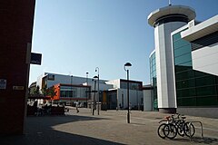
Didcot is a town of 22,000 people in south Oxfordshire , 16 km south of Oxford . Didcot belonged to Berkshire until a border change in 1974 .
Didcot was an important railway junction in the First World War , as a connection for the routes from London , Bristol and Oxford to Southampton had been here since 1882 . The railway line was expanded to meet the requirements of World War II in 1942/43, but in 1966 the connection to Southampton was closed.
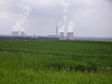
Didcot is best known today because of the controversial Didcot Powerstation . The two blocks of the power station, with a total of six cooling towers , were voted third in the UK's 10 worst malignancies by readers of Country Life 2003 magazine .
In the past, environmental protests have also sparked at the power plant, which runs on coal , natural gas and biogas . The Didcot A power plant stopped producing electricity in March 2013. On July 27, 2014, three cooling towers were blown up as part of the demolition of power plant A. When a large boiler house collapsed on February 22, 2016, there were dead and injured.
Since 2012 there has been a town partnership with the Bavarian town of Planegg .
swell
- ↑ BBC report
- ↑ Didcot power station towers demolished on BBC News , July 27, 2014, accessed July 27, 2014
- ↑ Four deaths feared from Die Rheinpfalz , February 25, 2016, accessed on February 27, 2016
- ↑ https://www.merkur.de/lokales/wuermtal/planegg/planegg-didcot- Werden-partner- 2260261.html


