Dietzenröder stone
| Dietzenröder stone | ||
|---|---|---|
|
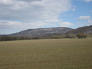
The Dietzenröder Stein seen from the direction of Sickenberg |
||
| height | 496.1 m | |
| location | Eichsfeld district , northwest Thuringia | |
| Mountains | Gobert , Thuringian Basin (with edge plates) | |
| Coordinates | 51 ° 17 '24 " N , 10 ° 2' 7" E | |
|
|
||
| rock | Shell limestone | |
| particularities | Lookout rock | |
The Dietzenröder Stein , also called Dietzenröder Klippen , is a 496.1 m high mountain and viewing rock in the west of the Eichsfeld district in Thuringia ( Germany ).
location
The mountain is located in the western part of the Eichsfeld district near the state border with Hesse . It lies between the small towns of Asbach-Sickenberg in the south and south-west and Dietzenrode in the west. The closest towns are Bad Sooden-Allendorf (4 kilometers to the southwest) and Heilbad Heiligenstadt (approx. 12 km to the northeast).
nature
The Dietzenröder Stein is the most south-westerly and highest elevation of the small mountain plateau Auf dem Stein . Immediately on the western edge of the precipice there is a rock wall made of shell limestone , the so-called Dietzenröder cliffs . A few benches invite you to rest after the ascent. From here you have a wonderful view of the nearby Walse and Werra valleys and the adjacent mountainous region in western Eichsfeld with the Höheberg and in northeastern Hesse with the Soodener Bergland , Hohen Meißner and Kaufunger Wald as far as the southern Leinebergland .
Numerous hiking trails lead from the surrounding villages to the lookout point.
Individual evidence
Web links
- The vantage point on the Dietzenröder cliffs on panorama-photo.net
- Premium hiking trail P16 including to Dietzenröder Stein


