Dikili Tash

Dikili Tash ( Greek Ντικιλί Τας from Turkish Dikilitaş , 'upright stone', obelisk ) or Megalo Lithari ( Μεγάλο Λιθάρι 'big stone' ) is a hill in the plain of Drama in Macedonia in the northeast Greek municipality of Kavala . The hill rises about 16 m above the plain on the eastern edge of the modern town of Krinides , about 1.7 km east of ancient Philippi . With an area of over 4.5 hectares, Dikili Tash is one of the largest settlement mounds from the Neolithic in the Balkans .
designation
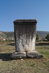
The hill was named after a 4 m high Roman stone pedestal that was erected about 200 m northeast of Dikili Tash in the 1st century AD in honor of the Roman officer Gaius Vibius Quartus. At that time the Via Egnatia ran directly south of the stone base. The marble base is inscribed on two sides, the western and southern. The inscription was destroyed by the villagers in the past in the lower part. It was believed that the pedestal was the manger of Bucephalus , Alexander the Great's favorite horse , and the nursing women therefore rubbed marble from the pedestal and mixed it with their milk in the hope that their sons could attain strength as strong as Alexander. The inscription reads:
C(aius) Vibius C(aii) f(ilius)
Cor(nelia) Quartus
mil(es) leg(ionis) V Macedonic(ae)
decur(io) alae Scubulor(um)
praef(ectus) coh(ortis) III Cyreneic(ae)
trib(unus) leg(ionis) II Augustae
praef(ectus) ...
Translation:
Gaius Vibius Quartus, Sohn des Caius,
aus der Familie der Cornelier,
Soldat der Legio V Macedonica,
Decurio der Ala der Scubuler,
Kommandant einer Kohorte der Legio III Cyrenaica,
Militärtribun der Legio II Augusta,
Kommandant ...
exploration
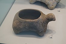
In 1917/1918, Carl Blegen and Francis Bertram Welch visited Dikili Tash and examined the hill. They found many prehistoric pottery shards on the surface. From 1920 to 1922 Louis Renaudin carried out the first excavations. In addition to Neolithic ceramics, he found two foundations of Roman heroes at the spring northeast of the hill . Systematic excavations were carried out by the École française d'Athènes and the Athens Archaeological Society under the direction of Jean Deshayes and Dimitrios R. Theocharis . Dikili Tash's collaborative research continued from 1986 to 1996 under the direction of Chaido Koukouli-Chryssanthaki and René Treuil . Since 2008, the excavations have been resumed under the direction of Pascal Darcque, Chaido Koukouli-Chryssanthaki, Dimitra Malamidou and Zoï Tsirtsoni. It is planned to open the excavation to the public. The finds are exhibited in the Archaeological Museum of Philippi and the Archaeological Museum of Kavala .
history
The hill originally barely rose above the plain, but was protected by two incisions on two sides. The earliest settlement is only known from drilling. Using the radiocarbon method , this could be carried out in the second half of the 7th millennium BC. BC, i.e. in the early Neolithic period . Traces of settlement from this period were found on the summit and near the source on the eastern and northeastern slopes.
Neolithic
The oldest known building remains come from the late Neolithic I (sector 6). This settlement phase lasted for 400 to 500 years and lasted approximately from 5,300 to 4,800 BC. Chr. The Tell grew during this period by about 5 m to. The parallel rectangular houses had a northeast-southwest orientation and were separated from each other by narrow paths. The buildings had built-in storage vessels, millstones, and ovens. In building 1, the remains of a charred mat lay on the floor. The vessels were often brown on light beige (Akropotamos style) or orange. There were also black vessels with a spiral incised pattern. The so-called House of Bukranion dates from the end of this period (4,900-4,800 BC) . It was about 7 m long and 5 m wide with a rectangular floor plan. It had a wooden framework that was lined with clay and plastered. Inside were an oven, a tripod for cooking, a vessel with charred barley grains , grinding and grating stones and several clay vessels. These items were probably all used to prepare food. The most notable find is a bucranion, a cattle skull with horns covered with clay, which was probably attached to a wall or a beam.
Charcoal from the archaeobotanical mud is evidence of the use of oak, ash, hornbeam and maple.
The following settlement in late Neolithic II lasted about as long as the first, roughly from 4,700 to 4,300 BC. However, the settlement layer is only 2 to 4 m thick. The houses were aligned as before, but the settlement was larger. The pottery from this period was mainly decorated with incised drawings. But there were also pots decorated with graphite or painted in black on red. As could be proven with radiocarbon dating and thermoluminescence dating , the settlement was 4,300 / 4,260 BC. Destroyed by fire. For about 100 years there were few residents until Dikili Tash was finally abandoned.
Bronze age
During the Early Helladic period around 3,300 / 3,000 BC. The hill was populated again. Traces of settlement were found all over the hill - except in the south. They consisted of six consecutive layers with a total thickness of over 2 m. The houses were arranged and oriented in a similar way as in the Neolithic period. Their construction was also comparable. However, they had a stone foundation. After 2,800 BC This settlement phase ended.
The destruction of a floor made of clay could be based on 14 C data on about 1150 BC. BC, i.e. in the Late Helladic (SH IIIC). A bronze dagger was also found from this period. The extent of this settlement is not known.
Historic time
From the Classical , Hellenistic and Roman times , only ceramic and coin finds are known. Some Roman tombs were found nearby. In the 12th century, in Byzantine times , a tower was built on the highest point of the hill, which was destroyed in the 13th or 14th century.
Web links
literature
- Chaido Koukouli-Chrysanthaki, Charalambos Bakirtzis: Philippi . Athens 2007, ISBN 978-960-214-239-4 , pp. 6-7, 60-61, 71-73.
Individual evidence
- ↑ Dimitria Malamidou: An Investigation of Neolithic settlement pattern and plant exploitation at Dikili Tash: Reconsidering old and new data from the late 5th Millennium BC settlement. In: In: Apostolos Sarris (Hrsg.): Communities, landscapes and interaction in Neolithic Greece. Ann Arbor, International Monographs in Prehistory 2017, 60
- ^ Léon Heuzey , Honoré Daumet : Mission archéologique de Macédoine. , Paris 1876, pp. 45-47. ( online )
- ^ FB Welch: Macedonia: prehistoric pottery. in The Annual of the British School at Athens , 23 (1918-19), pp. 44-50.
- ↑ Chronique des fouilles et découvertes archéologiques dans l'Orient hellénique (November 1919-November 1920) in Bulletin de correspondance hellénique 44 (1920), p. 407 ( online )
- ↑ Chroniques des fouilles et découvertes archéologiques dans l'Orient hellénique. in Bulletin de Correspondance Hellénique. 45 (1921), pp. 543-544. ( online )
- ↑ Chronique des fouilles et découvertes archéologiques dans l'Orient hellénique (November 1921-November 1922). In: Bulletin de Correspondance Hellénique. 46, pp. 527-528 (1922). ( online )
- ↑ Dimitria Malamidou: An Investigation of Neolithic settlement pattern and plant exploitation at Dikili Tash: Reconsidering old and new data from the late 5th Millennium BC settlement. In: Apostolos Sarris (Ed.): Communities, landscapes and interaction in Neolithic Greece. Ann Arbor, International Monographs in Prehistory 2017, 62
- ↑ Dimitria Malamidou: An Investigation of Neolithic settlement pattern and plant exploitation at Dikili Tash: Reconsidering old and new data from the late 5th Millennium BC settlement. In: Apostolos Sarris (Ed.): Communities, landscapes and interaction in Neolithic Greece. Ann Arbor, International Monographs in Prehistory 2017, 69
- ↑ Dimitria Malamidou: An Investigation of Neolithic settlement pattern and plant exploitation at Dikili Tash: Reconsidering old and new data from the late 5th Millennium BC settlement. In: Apostolos Sarris (Ed.): Communities, landscapes and interaction in Neolithic Greece. Ann Arbor, International Monographs in Prehistory 2017, 70
Coordinates: 41 ° 0 ′ 37 " N , 24 ° 18 ′ 32" E


