Rupa-Rupa District
| Rupa-Rupa District | |||
|---|---|---|---|
 Location of the district in the province of Leoncio Prado |
|||
| Symbols | |||
|
|||
| Basic data | |||
| Country | Peru | ||
| region | Huánuco | ||
| province | Leoncio Prado | ||
| Seat | Tingo María | ||
| surface | 264 km² | ||
| Residents | 53,066 (2017) | ||
| density | 201 inhabitants per km² | ||
| founding | September 9, 1946 | ||
| ISO 3166-2 | PE-HUC | ||
| Website | www.munitingomaria.gob.pe/mplp/ (Spanish) | ||
| politics | |||
| Alcalde Provincial | Miguel Ángel Meza Malpartida (2019-2022) |
||
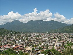
| View over Tingo María | |||
Coordinates: 9 ° 18 ′ S , 76 ° 0 ′ W
The Rupa-Rupa district is located in the Leoncio Prado province in the Huánuco region in central Peru . The district was established on May 27, 1952.
The Rupa-Rupa district has an area of 264 km². The 2017 census counted 53,066 inhabitants. The administrative seat of the district is the provincial capital Tingo María with 46,191 inhabitants (as of 2017) located at an altitude of 649 m on the right bank of the Río Huallaga .
Geographical location
The district is centrally located in the province of Leoncio Prado. It includes the city of Tingo María on the right bank of the river and the area north of the lower reaches of the Río Monzón .
The district Rupa Rupa is bordered to the south by the district Mariano Damaso Beraun , in the southwest of the district Monzón , in the northwest to the districts José Crespo y Castillo and Pueblo Nuevo , on the north by the district Castillo Grande and the east by the district Luyando .
Individual evidence
- ↑ PERU: Huánuco Region - Provinces and Districts . www.citypopulation.de. Retrieved April 12, 2020.


