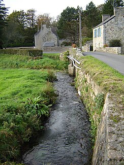
Divette (English Channel)
| Divette | ||
|
The Divette in Sideville |
||
| Data | ||
| Water code | FR : I65-0400 | |
| location | France , Normandy region | |
| River system | Divette | |
| source | in the municipality of Bricquebosc 49 ° 31 ′ 29 ″ N , 1 ° 42 ′ 40 ″ W |
|
| Source height | approx. 98 m | |
| muzzle | in the harbor basin of Cherbourg-Octeville in the English Channel Coordinates: 49 ° 39 ′ 28 " N , 1 ° 36 ′ 44" W 49 ° 39 ′ 28 " N , 1 ° 36 ′ 44" W |
|
| Mouth height | 0 m | |
| Height difference | approx. 98 m | |
| Bottom slope | approx. 3.5 ‰ | |
| length | 28 km | |
| Right tributaries | Trottebec | |
| Medium-sized cities | Cherbourg-Octeville | |
The Divette is a coastal river in France that runs in the Manche department in the Normandy region . It rises in the municipality of Bricquebosc , first drains in a north-westerly direction, then turns to the north-east and flows into the English Channel after 28 kilometers in the Cherbourg-Octeville harbor basin .
Places on the river
(Order in flow direction)
Individual evidence
- ↑ Source geoportail.gouv.fr
- ↑ estuary geoportail.gouv.fr
- ↑ a b The information on the length of the river is based on the information about the Divette at SANDRE (French), accessed on November 11, 2013, rounded to full kilometers.

