
Diyala
| ديالى Diyālā
|
|
|---|---|
  |
|
| Basic data | |
| Country | Iraq |
| Capital | Baquba |
| surface | 17,685 km² |
| Residents | 1,271,000 (as of 2003) |
| density | 72 inhabitants per km² |
| ISO 3166-2 | IQ-DI |
 |
|
Coordinates: 34 ° 0 ' N , 45 ° 0' E
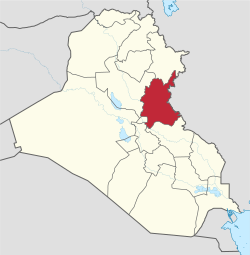
Diyala ( Arabic ديالى, DMG Diyālā ) is one of the 18 Iraqi governorates . The capital is Baquba . The governorate begins northeast of Baghdad and extends to the Iranian border.
Location and population
Diyala covers an area of 17,685 km². In 2003, the estimated population was 1,271,000, mostly Sunni Arabs . The governorate is crossed by the Diyala river of the same name , one of the main tributaries of the Tigris . Date and orange plantations are typical of the region .
Administrative structure
The governorate is divided into six districts:
The Kurdish part is partly ruled by the Kurdistan Autonomous Region .
On October 15, 2005, 51.27% of 476,980 voters voted yes for the new constitution.
Since July 2006, the newly established 5th Infantry Division of the Iraqi Army as part of the Multinational Armed Forces in Iraq has also been responsible for the security of the governorate and the border with Iran .
Web links
al-Anbar |
Babil |
Baghdad |
Basra |
Dahuk |
Dhi Qar |
Diyala |
Erbil |
Halabja |
Chervil |
Kirkuk |
Maisan |
al-Muthanna |
an-Najaf |
Ninawa |
al-Qadisiyya |
Salah ad-Din |
as-Sulaimaniyya |
Wasit
Autonomous Region: Kurdistan Autonomous Region