Dolmen at Dystrup Sø

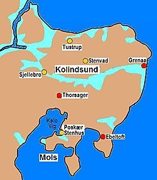
The dolmen at Dystrup Sø ( German "Dystrupsee" ) are located in the north of the east Jutland peninsula Djursland near the dolmen of Stenvad . The megalithic graves date from the Neolithic Age , around 3500–2800 BC. And are megalithic systems of the funnel beaker culture (TBK). Neolithic monuments are an expression of the culture and ideology of Neolithic societies. Their origin and function are considered to be the hallmarks of social development. South of Stenvad are the heather and the forest of Ramten , where the facilities are located. The area is rich in dolmens and forms the northern counterpart to the concentration around Nødager , south of the Kolindsund . The area in the north was an island in the Neolithic .
The northern plants
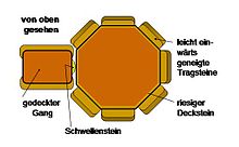
The best preserved is the 19.0 × 9.0 m long barn bed with two dolmens, almost 100 m north of the Hovlinen road. The facility was restored in 1887. However, there is no excavation report. It is possible that the hill initially contained only one chamber and was only extended when another was added. The long oval mound of earth is surrounded by several large, partly fallen stones, the original border. The south-facing corridor to the pentagonal chamber of the polygonal dolmen has been partially preserved in the eastern dolmen. Small bowls can be seen on the large capstones of the chamber , which were picked in the Bronze Age (1,800–500 BC). The gussets between the orthostats are still partially filled with intermediate masonry. The corridor of the western chamber has not been preserved, but there is a threshold stone in the entrance opening to the northeast. The only capstone of the chamber is supported by four bearing stones.
The southern plants
300 m east and south of the road Hovlinen there are two more megalithic systems in the field. One is almost completely destroyed. A little further there is a long hill with two chambers, of which the eastern one is better preserved. It has a large, flat, partly blasted capstone. The mound of earth is almost eroded, especially the western end on the field; but it is still recognizable from the remaining curbs. The western chamber, in the area of which there are many destroyed stones, is badly disturbed. There is neither archaeological knowledge nor information about finds in these facilities.
The flora of the stone age
From the "Fuglsø Mose" (moor), which was used for peat extraction in the 19th century, there are pollen analyzes that show that the area was forested mainly with birch, oak, ash, hazel, linden and elm during the Neolithic period . In this thick deciduous forest, the TBK people cut clearings for their villages and fields. This promoted the growth conditions for grasses and herbs.
Deposit
After the children found part of a short sword from the earliest Bronze Age in the potato field in 1993 , the location was searched with the detector. It was possible to find a depot of eight bronze swords. The swords lay directly below the plow level and only chance prevented them from being hit by field devices. Dating is not yet available.
See also
literature
- Karsten Kristiansen (Red.): På tur i Djurslands Fortid . 2nd edition Landkabkontoret, Århus 1993.
- Poul H. Jensen: Nature and culture guide for Århus County (“Natur- og Kulturguide til Århus”). Aarhus County, Aarhus 1997, ISBN 87-90099-21-4 .
- Peter Vilhelm Glob : Danske Oldtidsminder . Gyldendal, Copenhagen 1967 (reprint of the Copenhagen 1948 edition).
- Peter Vilhelm Glob: prehistoric monuments of Denmark . Wachholtz, Neumünster 1967.
- Jakob Vedsted: Fortidsminder og Kulturlandskab - en kildekritisk analysis af tragtbaegerkulturens found material from northern Jursland. Forlaget Skippershoved, Ebeltoft 1986, ISBN 87-981329-5-4 .
Individual evidence
- ^ Johannes Müller : Neolithic Monuments and Neolithic Societies . In: Hans-Jürgen Beier : Varia neolithica, Vol. 6: Neolithic monuments and Neolithic societies. Contributions to the meeting of the Neolithic Working Group (Contributions to the prehistory and early history of Central Europe; Vol. 56). Verlag Beier & Beran, Langenweißbach 2009, ISBN 978-3-941171-28-2 , pp. 7-16, here p. 15.
Web links
- Dystrup Sø dysser at Danske Fortidsminder (Danish)
- Deposit No. 315
Coordinates: 56 ° 27 ′ 21.3 ″ N , 10 ° 36 ′ 48.3 ″ E
