Kolindsund
| Kolindsund, Denmark | ||
| Geographical location | ||
|
|
||
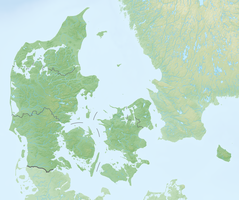
| Coordinates | 56 ° 21 '0 " N , 10 ° 38' 0" E | |
| Waters 1 | Baltic Sea | |
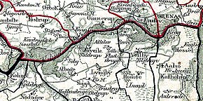
 Kolindsund 1827 |
||
Kolindsund is a depression that extends two meters below sea level between Kolind in the west and Grenaa in the east of the Djursland peninsula , Denmark . The area is 17 km long and one to two km wide, it covers a total of around 25 square kilometers. The embankments reach a height of up to 35 m. The Kolindsund was originally a body of water that was drained from 1872 .
history
A wide sound divided Djursland from the end of the Vistula Glacial Period to the Middle Ages . The northern part has long been an island . Later, as a result of the land uplift and siltation at the mouths , the sound became an inland body of water , initially Denmark's second largest lake. Such a change in the coastline is by no means unique. The Lystrupfjord north of Aarhus disappeared in the same way.
In 1872 Kolindsund was acquired by a stock corporation and essentially drained by 1880. However, the two pumping stations from 1937/38 could not prevent the site from gradually becoming swampy. Around a quarter of the arable land that was once used has been given up because it cannot be kept dry enough for agricultural cultivation. The aim of an organization "Friends of Kolindsund" is to renaturate the reed swamps and restore the lake. New sedge swamps have been forming on an area of 100 hectares since 1967 and this development is continuing with increasing speed.
The channels
The two Kolindsund canals (north and south) are among Denmark's most productive sea trout waters. Today, in summer, canoe trips on the South Canal are also offered from Kolind .
literature
- Brita Flou et al. a .: Kolindsund. Et stykke Djursland fortæller danmarkshistorie . Gennemgang af Kolindsunds udvikling og historie. Grenå 1980, ISBN 87-87629-15-1 .
Web links
- Project Kolindsund (Danish) Website of the municipalities of Syddjurs and Norddjurs
- Kolindsunds venner (German, Danish, English) citizens' initiative
- Kolindsund Wetlands (German) globalnature.org


