Keroyal dolmen
The Dolmen of Keroyal (also called Kerroyal or Roh-Vilhen) is completely inaccessible due to the thickness of the mud layer, in the flats of the Bono Canal, southwest of Keroyal , north of Plougoumelen in the Morbihan department in Brittany in France . In France, dolmen is the generic term for megalithic structures of all kinds (see: French nomenclature ).
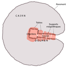
Zacharie Le Rouzic (1864–1939) was able to examine the dolmen in 1908; he already mentions the difficulties in accessing it. It is covered by the tide twice a day. Its base is about 2.0 m above the average level of the sea. It is a "dolmen a couloir" with a corridor made of 18 bearing stones and a chamber with a single ceiling plate, which is called Roh-Vilen ( German: "yellow rock" ) because of the algae growth . The entrance to the 3.0 to 2.6 m wide chamber is in the southeast. A side chamber measuring 1.55 × 1.18 lies on the north side. The dolmen is about 8.0 m long, of which 4.2 m is accounted for by the 0.9 m wide corridor.
Sea level rise
Allées couvertes, such as Kernic, are evidence of the rise in sea levels since the Neolithic , when the plants were not built so close to the sea . Examples are the Allée couverte in the Estuaire de la Quillimadec , the Cairn de Îlot-de-Roc'h-Avel and the menhirs of Penloïc near Loctudy (Finistère) and of Léhan . Another submerged dolmen ( French dolmen submergé ) is the Dolmen de la Table in front of the Île de Noirmoutier in the Vendée department . The dolmen of Karech-Loir on the Plage de Légenèse has completely disappeared.
See also
literature
- Jacques Briard : Mégalithes de Bretagne. Ouest-France, Rennes 1987, ISBN 2-7373-0119-X .
- Reena Perschke: A propos des mégalithes disparus et oubliés: Le dolmen de Karech-Loir .
Web links
Individual evidence
- ↑ Ker is a Breton appellative that is often used as a prefix for place names. It means: "inhabited place".
- ↑ http://www.sahpl.asso.fr/SITE_SAHPL/Le_Cam_Gaby_A%20propos%20des%20m%C3%A9galithes%20disparus%20et%20oubli%C3%A9s.pdf
Coordinates: 47 ° 39 '53.7 " N , 2 ° 55' 35.9" W.


