Dongxiang (Fuzhou)
| Dōngxiāng Qū 东乡 区 Dongxiang |
||
|---|---|---|
|
|
||
| Coordinates | 28 ° 15 ′ N , 116 ° 36 ′ E | |
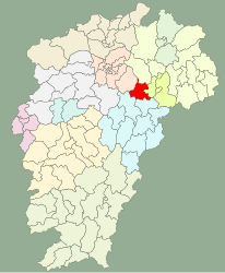
 Location of Dongxiang (red) within Jiangxi Location of Dongxiang (red) within Jiangxi
|
||
| Basic data | ||
| Country | People's Republic of China | |
| Jiangxi | ||
| District-free city | Fuzhou | |
| ISO 3166-2 | CN-JX | |
| surface | 1196 km² | |
| Residents | 480,000 (2017) | |
| density | 401.3 Ew. / km² | |
| Website | www.jxfzdx.gov.cn | |
|
Dongxiang town center
|
||
Dongxiang ( Chinese 东乡 区 , Pinyin Dōngxiāng Qū ) is a district in the northeast of the Chinese province of Jiangxi . It belongs to the administrative area of the prefecture of Fuzhou City . The district has an area of 1196 square kilometers and in 2017 had a total population of 480,000. 220,000 people live in the urban area.
The 2000 population census showed a total population of 383,069 people in 96,158 households in what was then Dongxiang County, of whom 201,186 were men and 181,883 women.
Dongxiang is bordered by Yugan in the north, Yujiang in the east, Jinxi in the south, Linchuan and Jinxian in the west. It covers an area to the east of the Jiangxi Hills and the Poyang Lake Plain . The relief slopes slightly from northeast to southwest and is characterized by rolling hills. The highest point is the 498 meter high Jinfeng Ling (金峰岭).
Dongxiang has deposits of gold , copper , lead , zinc , tin and clay . Wet rice , sugar cane , vegetables, citrus fruits, tea, peanuts and Camellia oleifera are grown. Important branches of the economy are the processing of agricultural products, especially sugar production, pharmaceuticals, mechanical engineering, metallurgy, construction, chemistry, ceramics production, wool spinning and silk reeling.
Dongxiang is on the Shanghai-Kunming railway line . The Shanghai – Kunming (G60) , National Road 307 and Provincial Road 208 pass through Dongxiang.
Dongxiang attractions include An Shi House (安石 故居), Longshanshi Shui Area (龙山 师 水) and Qinghu Temple.
Administrative structure
Dongxiang was established as a county in 1512. On March 6, 2017, it was converted into a municipality.
At the municipal level, the city district consists of a street district , nine large municipalities and four municipalities and some state economic units that are directly subordinate to the city district. These are:
- Quarter Road New Haven (金峰街道)
- Large communities Xiaogang (孝 岗镇), Xiaohuang (小 璜 镇), Weishangqiao (圩 上 桥镇), Maxu (马 圩镇), Zhanxu (詹 圩镇), Gangshangji (岗 上 积 镇), Yangqiaodian (杨桥 殿镇), Lixu (黎 圩镇), Wangqiao (王桥镇)
- Municipality of Pogan (珀 玕 乡), Dengjia (邓 家乡), Huwei (虎 圩乡), Yaowei (瑶 圩乡)
- Red Star Land Reclamation Area (红星 垦殖场), Red Light Land Reclamation Area (红光 垦殖场), Red Luminous Land Reclamation Area (红亮 垦殖场), Gankang Forest Area (甘 坑 生态 林场), Jiangxi Phosphate Plant (江西 磷肥厂), Dongxiang Industrial Area (东乡 县 经济 开发区)
The seat of government in the district is the Xiaogang (孝 岗镇) municipality .
Web links
Individual evidence
- ↑ 东乡 区 情 简介.中共 东乡 区委 东乡 区 人民政府, April 2, 2019, accessed July 18, 2019 (Chinese).
- ↑ a b c 东乡 撤 县 设 区 新闻 发布会 召开.中共 东乡 区委 东乡 区 人民政府, March 6, 2017, accessed on July 18, 2019 (Chinese).
- ↑ 江西省 乡 、 镇 、 街道 人口. State Statistics Office of the People's Republic of China , accessed June 11, 2019 (Chinese).
- ↑ a b c d 东乡 县 概况 地图.行政 区划 网, August 22, 2016, accessed on July 20, 2018 (Chinese).
- ↑ 东乡 区. State Statistics Office of the People's Republic of China , accessed June 11, 2019 (Chinese).

