
Dreiländereck (at the Willersbach)
| Tri-border region | |
|---|---|
 The boundary stone (Styrian side) |
|
| Data | |
| place | Willersdorfer Schlucht , near Oberschützen , Hochneukirchen-Gschaidt , Schäffern |
| Client | Provinces Burgenland , Lower Austria , Styria |
| Construction year | 1914 (?) |
| Coordinates | 47 ° 25 '20.6 " N , 16 ° 10' 18.3" E |
| particularities | |
| Common boundary stone of the three federal states | |
The border triangle is a border stone that marks the Burgenland - Lower Austria - Styrian border.
location
The border point is in the Bernstein Mountains , on the edge of Wechselland and Buckliger Welt , in the valley of the Willersbach . This forms a wild and romantic deepening, the Willersdorfer Gorge , which shows a small widening on site. Here the upper Willersbach runs from north to south, from the west a channel comes from the Gamperl farm, from the east a stream from Offenegg . The stone is a little east of the stream.
The boundary stone marks the boundaries of the cadastral communities of Gschaidt in the north, Hochneukirchen in the east, Schmiedrait in the south and Götzendorf in the west, and thus those of the political communities Hochneukirchen-Gschaidt , Oberschützen and Schäffern , the political districts Wiener Neustadt-Land , Oberwart and Hartberg-Fürstenfeld , the regions of industrial district , southern Burgenland and eastern Styria as well as the states of Lower Austria, Burgenland and Styria.
The point is the easternmost point in Styria, but not the southernmost point in Lower Austria (the state border is on the Offenegg − Oberschützen / L353 road 2 kilometers east of here, a few meters further south ⊙ ). It is not clearly visible along the Burgenland border.
Structural matters
The stone is a stone stele , a three-sided, flat-topped pyramid with a round base, about waist-high overall. The three sides are decorated with the national colors of the countries, in small round cartouches with trapezoidal cartouches below, in which the abbreviations of the countries are also in old German letters ("Bgld" on red-yellow , "NÖ" on blue-yellow , "Stmk" on green-white ).
The stone stands in a clearing, with a small wooden hut, the Dreiländereckhütte , and a designed resting place. The place is easy to reach on the hiking trails in the area.

Border stone, Lower Austrian and Burgenland side
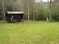
The Dreiländereckhütte


history
The place used to be the border between the manors Ziegersberg (near Zöbern, now in ruins) and Krumbach in the Archduchy of Austria , Bärnegg (near Elsenau, now in ruins) in the Duchy of Styria , and Bernstein (Borostyánkő) in the Kingdom of Hungary . Already in the 17th century there was a border mark called Vierherrschaft Stein .
The current stone was probably set in 1914, there are no written records of the date. It has not marked a national border since 1921 , in that year German West Hungary came to Austria and became Burgenland.
See also
Web links
Individual evidence
- ↑ Recorded in the current Austrian map 1: 50,000 (ÖK50), but not located in the Geonam Austria database (BEV: Austria Map online , accessed October 29, 2017).
- ↑ The tip of the border on the Rittschein (on Winkelgraben) is a good 1200 meters to the west.
- ↑ a b c Hochneukirchen-Gschaidt tourism and beautification association: On-site information board, undated ( photo , Wikimedia Commons, 2014).