Drut
|
Drut Друть, Друць (Druz) |
||
|
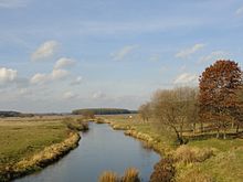
The Drut Basin with Aslik, Vabich and Greza |
||
| Data | ||
| location | Wizebskaja Woblasz , Mahiljouskaja Woblasz , Homelskaja Woblasz ( Belarus ) | |
| River system | Dnepr | |
| Drain over | Dnepr → Black Sea | |
| source |
Belorussian ridge north of Talachyn 54 ° 29 ′ 53 ″ N , 29 ° 45 ′ 55 ″ E |
|
| muzzle | south of Rahatschou in the Dnieper Coordinates: 53 ° 3 '26 " N , 30 ° 1' 46" E, 53 ° 3 '26 " N , 30 ° 1' 46" E
|
|
| length | 295 km | |
| Catchment area | 5020 km² | |
| Discharge at the gauge near the mouth |
MQ |
30 m³ / s |
| Reservoirs flowed through | Tschyhiryner reservoir | |
| Medium-sized cities | Rahatschou | |
| Small towns | Talachyn | |
| Navigable | Lower course | |
|
Location of the Drut (Друць) in the catchment area of the Dnepr |
||
The Drut ( Belarusian Друць (Druz), Łacinka Druć, Russian Друть (Drut)), a right tributary of the upper Dnepr in Belarus , 295 km long, rises in the western Russian ridge , approx. 45 km west-southwest of Orsha and flows 100 km south-south-west Mahiljou (Mogiljow); in the lower reaches it is navigable and ice-free from the end of March to November.
Individual evidence
- ↑ a b c Article Drut in the Great Soviet Encyclopedia (BSE) , 3rd edition 1969–1978 (Russian)


