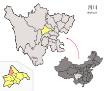
Dujiangyan
Dujiangyan ( Chinese 都江堰 市 , Pinyin Dūjiāngyàn Shì ) is an independent city that belongs to the administrative area of the independent city of Chengdu in the southwest Chinese province of Sichuan . It is located at the point where the Min River ( Min Jiang ), after being dammed in the new Zipingpu Dam , pours out of the hill country into the Chengdu plain .
Dujiangyan has an area of 1,207 km² and approx. 590,000 inhabitants (2001). Administratively, the city is made up of 17 large municipalities .
Qingcheng Shan Mountain , a UNESCO World Heritage Site, and the Changdao Guan Temple located on it, are located in the Dujiangyan area.
Weir system
The Dujiangyan irrigation system has been on the List of Monuments of the People's Republic of China and UNESCO's World Heritage List since 1982 .
2008 Sichuan earthquake
On May 12, 2008 , the city was hit by a severe earthquake and most of it was destroyed.
Administrative structure
Dujiangyan consists of seventeen large municipalities , two municipalities and other smaller administrative units:
- Greater community Guankou灌口镇
- Greater community Xingfu幸福镇
- Greater community Puyang蒲阳镇
- Greater community Zhongxing中兴镇
- Greater community Juyuan聚源镇
- Greater community Tianma天马镇
- Greater community Chongyi崇义镇
- Greater community Longchi龙池镇
- Greater community Liujie柳街镇
- Greater community Xujia胥家镇
- Anlong Municipality 安 龙镇
- Greater community Daguan大观镇
- Greater community Zipingpu紫坪铺镇
- Greater community Cuiyuehu翠月湖镇
- Greater community Shiyang石羊镇
- Large village Yutang玉堂镇
- Greater community Qingchengshan青城山镇
- Community Xiang'e向峨乡
- Community Hongkou虹口乡
Individual evidence
- ↑ Archive link ( Memento of the original from May 17, 2008 in the Internet Archive ) Info: The archive link was automatically inserted and not yet checked. Please check the original and archive link according to the instructions and then remove this notice. 2004 (49 个 社区 委员会 、 333 个 村委会) The population figures of the large municipalities and municipalities before the regional reform can be found in the link (year 2000).
Coordinates: 31 ° 0 ' N , 103 ° 37' E
