Dunadd
Dunadd (or Dunadd Fort or Dunadd Hillfort; actually Dun add) is located west of the River Add, north of Lochgilphead and south of Kilmartin near the River Add in Argyll and Bute ( Scotland ) on a rock about 50 m high. The A816 road runs just a few hundred yards east of the Iron Age Hillfort , which is mentioned twice in the Annals of Ulster . " Dun -Add" is named after the nearby river add.
Dunadd was the principal place in this part of Scotland between 500 and 900 AD as the capital and coronation site of the Dalriada kingdom . The Scots, who immigrated primarily from County Antrim in Northern Ireland during the Dark Ages , from around 500 AD, founded the kingdom.
The Pict king Oengus or Onuist, as his name should be in Pictish, son of Fergus devastated Dalriada and occupied Dún At. Onuist was one of the most powerful Pict kings of the 8th century and the mention of Dunadd in connection with the devastation of the Dalriadas implies that it was a place of importance. But Dalriada recovered and turned the tables. In 843, Kenneth MacAlpin , King of the Scots of Dalriada, also became King of the Picts . Under pressure from the Viking raids , he moved the center from coastal Dunadd to Scone , near Perth , in 850 . That was the end of Dunadd's glory days.
Dunadd was excavated by archaeologists in 1904, 1929, 1950, and most recently in the 1980s. It originally had four walls on different levels. The layout with the outer defense line around a stronghold corresponded almost to the Motte and Bailey type of castle, which the Normans only introduced centuries later.
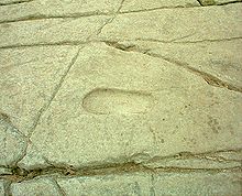
A small section of the original fortress wall has been preserved on the summit. A slab of rock on the summit has a deepened cavity, the purpose of which is unknown. Another bears the imprint of the sole of a foot carved into the rock . The best preserved footprint is 27 cm long, almost 11 cm wide, 9 cm in diameter at the heel and 2.5 cm deep, so that a foot can fit inside a shoe or boot. It is believed that, according to Irish tradition, the King of Dalriada was consecrated by setting his foot in the rocky replica. Engraved nearby is an Ogam text, after Katherine Forsyth from the 9th century, the meaning of which is unknown. The engraving of a wild boar (or a bear) on a rock slab has been relocated to the garden of one of the houses at the foot of the fortress.
The archaeologists found that during the Dark Ages, the kings enjoyed rare dishes, exquisite foods, imported herbs, and expensive clothing dyes. The analyzes found traces of dill and coriander . About 20 stones belong to hand turning mills that were associated with D-goods. From AD 650, jewelry was made locally from gold, silver, amber and glass, in the form of brooches and needles, combining Pictorial, Celtic and Anglo-Saxon design elements . Some engraved stone fragments and a pendant made of slate , depicting animals and rosette-like knot patterns are among the special features. It is entirely possible that the Hunterston brooch, considered Irish work, was made in Dunadd. Continental ceramics, finely crafted glassware and raw materials from the Mediterranean are evidence of long-distance trade.
Immediately to the east, near Dunaff Farm, are the two menhirs of Dunadd. The larger one is 4.3 m long.
literature
- Anna Ritchie: Scotland BC. An introduction to the prehistoric houses, tombs, ceremonial monuments and fortifications in the care of the Secretary of State for Scotland . Scottish Development Dept., Edinburgh 1989, ISBN 0-11-493427-4 .
Individual evidence
- ↑ in the sense of a successor ritual - "following in the footsteps of (the predecessor)"
Web links
Coordinates: 56 ° 5 '8.8 " N , 5 ° 28' 43.8" W.


