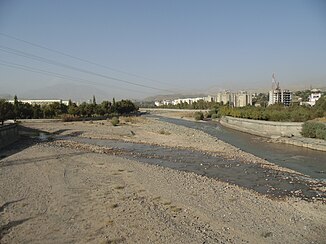
Warsob
|
Warsob - Dushanbinka Варзоб, Варзо́б |
||
|
Warsob near Dushanbe |
||
| Data | ||
| location | Tajikistan | |
| River system | Amu Darya | |
| Headwaters |
Hissar Mountains 38 ° 58 ′ 30 ″ N , 68 ° 57 ′ 3 ″ E |
|
| muzzle | south of Dushanbe in the Kofarnihon Coordinates: 38 ° 29 ′ 27 ″ N , 68 ° 46 ′ 31 ″ E 38 ° 29 ′ 27 ″ N , 68 ° 46 ′ 31 ″ E
|
|
| length | 71 km | |
| Catchment area | 1740 km² | |
| Discharge at the Dagana gauge ( ⊙ ) A Eo : 1270 km²
|
MQ 1936/1985 Mq 1936/1985 |
45.4 m³ / s 35.7 l / (s km²) |
| Drain at the Dushanbe gauge |
MQ |
53.5 m³ / s |
| Right tributaries | Sijama | |
| Big cities | Dushanbe | |
| Small towns | Warsob | |
The Warsob ( Tajik Варзоб ; Russian Варзоб , in the underflow also Duschanbinka ) is a right tributary of Kofarnihon in Tadschikistan .
geography
The Warsob rises on the southern flank of the Hissar Mountains . The 71 km long Warsob flows south through the mountains. It flows through the district of the same name and the district capital Warsob, which is also named after him . Later the river leaves the mountains and continues its course south. It flows through the capital Dushanbe and shortly thereafter flows into the Kofarnihon coming from the east. The Warsob is mainly fed by meltwater from the glaciers and snowmelt . At Dushanbe it shows a mean discharge (MQ) of 53.5 m³ / s. The Warsob drains an area of 1740 km². The river is also used for irrigation on the upper reaches . There are several hydropower plants on the Warsob. The M34 overland road , which leads from Dushanbe through the Ansob tunnel to Aini , initially runs along the course of the river.
Web links
Individual evidence
- ↑ a b c d Article Warsob in the Great Soviet Encyclopedia (BSE) , 3rd edition 1969–1978 (Russian)
- ↑ UNESCO: Varzob at Dagana (discharge data 1936–1985) ( Memento from August 8, 2014 in the Internet Archive )

