Aini (Tajikistan)
|
Aini (Tajikistan) Айнӣ |
||
| Basic data | ||
|---|---|---|
| State : |
|
|
| Province : | Sughd | |
| Coordinates : | 39 ° 24 ' N , 68 ° 32' E | |
| Height : | 1433 m | |
| Residents : | 2,000 | |
|
|
||
Aini ( Tajik Айнӣ ), also Ayni, Ajni , is a settlement and the capital of the subdistrict of the same name ( dschamoat ) within the district of the same name ( nohija ) in the province ( wilojat ) Sughd in northern Tajikistan . The place in the valley of the Serafshan , called Sachmatobod from 1930 to 1955 , got its current name in honor of the Tajik national poet Sadriddin Aini .
location
Aini is located at an altitude of 1433 meters in a mountain region called Serafshan north of the state capital Dushanbe . Most of the mountain peaks are over 3500 meters high and reach the maximum height of 5489 meters in the Serafschan chain. The mountain region is divided by long east-west running river valleys and connecting smaller transverse valleys and passes. The Serafshan valley is bounded in the north by the Turkestan chain and in the south by the parallel Serafschan chain. The place Aini lies at the confluence of the Fandarja coming from the south into the Serafshan. The Fandarja is mainly fed by the Jaghnob , whose gorge forms the next parallel valley south of the Serafschankette.
The distance from Dushanbe to Aini is around 140 kilometers on the M34 expressway, which initially leads almost half of the route from Dushanbe through the Warsob valley and then through the Ansob tunnel to the Jaghnob valley and finally runs along the Fandarja. The M34 is the only road connection within the country to the Fergana Valley in the north . From Aini, the M34 leads over the Turkestan chain and through the Schahriston tunnel to the first larger town of Schahriston in the Ferghana Valley and on to the provincial capital of Khujand, 180 kilometers away . Aini is an important traffic junction because the A377 branches off to the west on the Serafshan, downstream to the town of Punjakent . Punjakent can only be reached via this 90-kilometer-long, partially unpaved road that is being expanded by a Chinese company (as of 2014). The total distance from Aini via Punjakent to Samarkand is 165 kilometers, but the border with Uzbekistan is closed. A side road leading from Aini to the east opens up the upper Serafschantal, which otherwise has no trafficable access. The five kilometer long Ansob tunnel is in extremely poor condition; Before it opened in 2006, the unpaved road connection over the 3372 meter Ansob Pass was closed in the winter months between October and May, and so Aini and the Serafshantal were largely cut off from the outside world.
The average annual precipitation is 805 millimeters. Most of the precipitation falls in winter and spring, with the majority in March and April. Average temperatures vary between –7 ° C in January and 18.2 ° C in July.
District
The district ( nohija ) covers 5200 square kilometers. It was called Sachmatobod (Zahmatobod) between 1930 and 1955. In 1963 it was added to the western district of Punjakent and replaced by this again in 1965. In addition to Aini, the district includes the villages of Urmetan, Sarobod and Dardar in the west, Rars, Weschob and Schamtuch in the east, and Ansob and Serafschan am Jaghnob in the south. In the district is the largest hard coal mine in the country, Fan-Jaghnob, whose reserves are estimated at 800 million tons and which is exploited by a state company.
The approximately 72,000 inhabitants (2006) of the Aini district mainly practice arable farming and cattle breeding. In addition to the tobacco intended for sale, they grow wheat, potatoes, vegetables and fruit for self-sufficiency. Dried apricots are marketed and stored for the winter. In 2005, the area of irrigated fields per inhabitant was only half of the national average. For 2006 there are 27 collective and 70 family-run Dehkan farms. Dehkan-Farm ( chodschagihoi dehqoni , from dehqon , "farmer") has been the name of privatized farms since the Soviet land reform in 1996, which are still under a certain state tutelage. In the Aini district, for example, the state stipulates that tobacco must be grown on 30 percent of the land. In practice, the Dehkan collective farms function like the socialist kolkhozes that existed before independence in 1991 , in that they represent the basic organization of a village. Your manager collects taxes, which amount to 30 percent of the market price of the harvest.
According to studies from 2008, 17.4 percent of families have no land of their own, 32.5 percent have less than 0.1 hectare, 27 percent 0.1-0.2 hectares, 9.4 percent 0.2-0.5 Hectares, 2.2 percent 0.5-1 hectare, 3.2 percent 1-2 hectares, 1.6 percent 2-5 hectares and 5.4 percent over 5 hectares. This means that 86.3 percent of families (who own up to 0.5 hectares of land) are poor, 5.4 percent have a middle income and 1.6 percent make up the rich upper class, which includes members of the district administration and in some villages belong to the leading mullah . In many cases, the income earned from agriculture is insufficient to feed the families. Estimates from 2003 and 2004 assume that 30 percent of all families in the Aini district are directly dependent on remittances from a family member working in Russia. Their money transfers are a total of 13 times higher than the economic output in the district. Development programs try to increase productivity in agriculture.
According to information from 2006, around 960 hectares of 2500 hectares of arable land are irrigated by pumps from the Serafshan, which is buried deep in its bed over long stretches. The water is pumped from nine pumping stations and distributed over a 70-kilometer canal system. The pump operation is organized centrally by the water administration of the district based in Aini. Many villages direct water under their own direction from small mountain streams or springs onto the fields.
place
The expressway coming from Dushanbe crosses the Serafshan a few 100 meters above the confluence of the Fandarja. The place north of the bridge, Sangistan, consists of a few blocks of flats and crumbling industrial buildings, which are lined up along the road going east in the valley. From the confluence of this road it is about 1.5 kilometers to the west to the somewhat higher, compact settlement Aini on the northern (right) bank of the Serafshan. The houses reach up to the embankment that slopes steeply to the river. The M34 leads through the village and at its northern end again over a bridge to the left bank of the river. The junction to Punjikent is a good two kilometers northwest of the bridge and one kilometer before the village of Chushikat, where the M34 changes again to the north side of the river and the climb to the Schahriston tunnel begins. In front of Chuschikat, the runway of an airport runs parallel to the road, which is not regularly served. It should not be confused with the Aini military airport near Hissor , ten kilometers west of Dushanbe.
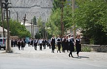
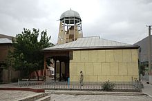
Aini has about 2000 inhabitants and the number is rising. The town center stretches for about half a kilometer along the through road and a parallel road to the west. There are some grocery stores, private guest houses and simple restaurants, as well as a school and a post office. The most important building is the mosque on the thoroughfare, the minaret of which dates from the 9th to 11th centuries. The mosque consists of an almost square room, the flat beamed ceiling of which is supported by a central wooden column. On two sides the room is extended by a pillar-supported forecourt, which the faithful lay out with carpets during prayer times. Woodwork from the 10th century was built into the building from the 20th century. The lower part of the 13-meter-high minaret made of adobe bricks has been preserved, which is wrapped in a sheet metal framework clad with plastic panels to protect it from the weather. Next to the mosque is a monument to the poet and scholar Sadriddin Aini (1878–1954), who gave the place its name.
In addition to being a resting place on the expressway, Aini is also known as a place where several development aid organizations are stationed. They include Deutsche Welthungerhilfe (German Agro Action), which has a guest house in addition to its office.
Individual evidence
- ↑ Ayni, Tajikistan. weatherbase.com
- ↑ Ayni Nohiya. In: Kamoludin Abdullaev, Shahram Akbarzadeh: Historical Dictionary of Tajikistan. Scarecrow Press, Lanham (Maryland), 2010, p. 72
- ↑ Doing Business in Tajikistan: 2012 Country Commercial Guide for US Companies. ( Memento of the original from May 18, 2015 in the Internet Archive ) Info: The archive link was inserted automatically and has not yet been checked. Please check the original and archive link according to the instructions and then remove this notice. US Commercial Service, Feb. 3, 2012
- ↑ Andreas Mandler: Knowledge and governance arrangements in agricultural production: Negotiating access to arable land in Zarafshan Valley, Tajikistan. Working paper. ZEF Working Paper Series No. 106, ZBW - Leibniz Information Center for Economics, 2012, pp. 13, 15
- ↑ Adam Vinaman Yao, Hubertus Rüffer: Paper 6: Food Security in Tajikistan: German Agro Action Strategy . ( Memento of March 4, 2016 in the Internet Archive ) Strategies for Development and Food Security in Mountainous Areas of Central Asia. International Workshop Dushanbe, Tajikistan June 6–10, 2005, p. 8
- ↑ Jennifer Sehring: The Politics of Irrigation Reform in Tajikistan . (Discussion Papers / Center for International Development and Environmental Research, No. 29) ZBW - Leibniz Information Center for Economics, 2006, pp. 16–18
- ^ Robert Middleton, Huw Thomas: Tajikistan and the High Pamirs . Odyssey Books & Guides, Hong Kong 2012, p. 139


