Serafschankette
| Serafschankette | ||
|---|---|---|
|
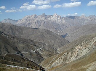
View from the Ansob pass to the Serafschankette |
||
| Highest peak | Tschimtarga ( 5489 m ) | |
| location | Tajikistan , Uzbekistan | |
|
|
||
| Coordinates | 39 ° 20 ′ N , 69 ° 40 ′ E | |
The Seraf Shankette is a mountain range in Tajikistan ( Central Asia ).
The Serafschankette runs in an east-west direction over a length of 370 km through the province of Sughd . It merges into the Alai Mountains in the east . In the north, the Serafshan chain is separated from the parallel Turkestan chain from the Serafshan river valley . The river valleys of Jagnob , Iskanderdarja and Saritag form the southern boundary to the Hissar Mountains . The western foothills of the Serafchan chain are in Uzbekistan . The rivers Fandarja , Kshtut and Magijandarja cut through the mountain range and divide it into four sections. The M34 highway between Dushanbe and Khujand runs through the valley of the Fandarja .
The mountain range in the Tschimtarga reaches a maximum height of 5489 m .
Web links
Individual evidence
- ↑ Article Serafschankette in the Great Soviet Encyclopedia (BSE) , 3rd edition 1969–1978 (Russian)

