Cofarnihon
|
Kofarnihon Кофарниҳон, Кафирниган (Kafirnigan) |
||
|
Cofarnihon in Wahdat |
||
| Data | ||
| location | Tajikistan | |
| River system | Amu Darya | |
| Drain over | Amu Darya → Aral Sea (temporarily) | |
| Confluence of |
Sardai-Mijona and Sorbo 38 ° 43 ′ 27 ″ N , 69 ° 19 ′ 26 ″ E |
|
| muzzle |
Amu Darya Coordinates: 36 ° 56 '13 " N , 68 ° 0' 53" E 36 ° 56 '13 " N , 68 ° 0' 53" E
|
|
| length | 387 km | |
| Catchment area | 11,600 km² | |
| Discharge at the Chinor gauge ( ⊙ ) A Eo : 3040 km²
|
MQ 1936/1985 Mq 1936/1985 |
101 m³ / s 33.2 l / (s km²) |
| Discharge at the Tartki gauge ( ⊙ ) A Eo : 9780 km²
|
MQ 1938/1985 Mq 1938/1985 |
158 m³ / s 16.2 l / (s km²) |
| Left tributaries | Ilyak | |
| Right tributaries | Simigantsch , Warsob , Chanaka | |
| Big cities | Dushanbe | |
| Medium-sized cities | Watch date | |
|
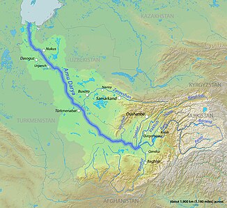
Course of the Kofarnihon (wrongly called Surkhan in the picture ) in the catchment area of the Amu Darya |
||
Kofarnihon ( Tajik Кофарниҳон ; Russian Кафирниган Kafirnigan ) is a right tributary of Amudarja in Tadschikistan .
The Kofarnihon arises at the confluence of its two source rivers Sardai-Mijona (right) and Sorbo (left), which arise in the Hissar Mountains . The river flows in a westerly direction. It flows through Wahdat , where the Simigantsch flows to it on the right. On the southern edge of Dushanbe , it includes the tributaries Warsob and Ilyak . The Chanaka flows further downstream from the right. Now the Kofarnihon turns south, in parts it forms the border with Uzbekistan . The Babatag mountain range runs west of the lower reaches. Passing Kubodijon and Schahritus , the Kofarnihon reaches the Amu Darya after 387 km.
The river drains an area of 11,600 km². It is mainly fed by the snowmelt . The mean water flow at the Tartki gauge about 50 km above the mouth is 158 m³ / s. The water of the Kofarnihon is used for irrigation , on its lower reaches mainly for the irrigation of cotton .
The Persian word kofarnihon means “place of the unbelievers” and is derived from the Arabic term kāfir , “unbeliever”. According to a legend for the origin of the name, which is related to the Chilu-chor chashma spring near Shahritus, the river dried up when Ali , cousin and son-in-law of the Prophet Mohammed , came to the area to preach Islam . Ali therefore cursed the river and gave it that name.
Individual evidence
- ↑ a b c Article Kofarnihon in the Great Soviet Encyclopedia (BSE) , 3rd edition 1969–1978 (Russian)
- ↑ UNESCO: Kafirnigan at Tartki (discharge data 1938–1985) ( Memento of the original from March 3, 2016 in the Internet Archive ) Info: The archive link was automatically inserted and not yet checked. Please check the original and archive link according to the instructions and then remove this notice.
- ↑ UNESCO: Kafirnigan at Chinor (discharge data 1936–1985) ( Memento of the original from March 4, 2016 in the Internet Archive ) Info: The archive link has been inserted automatically and has not yet been checked. Please check the original and archive link according to the instructions and then remove this notice.
- ↑ Chiluchor chashma . ( Memento of the original from January 27, 2015 in the Internet Archive ) Info: The archive link was inserted automatically and has not yet been checked. Please check the original and archive link according to the instructions and then remove this notice. Wonders of Tourism

