
Stari Grad Plain
| Stari Grad Plain | |
|---|---|
|
UNESCO world heritage |
|

|
|
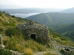
| View of the Stari Grad plain |
|
| National territory: |
|
| Type: | Culture |
| Criteria : | (ii) (iii) (v) |
| Surface: | 1.377 ha |
| Buffer zone: | 6.403 ha |
| Reference No .: | 1240 |
| UNESCO region : | Europe and North America |
| History of enrollment | |
| Enrollment: | 2008 (session 32) |
The Stari Grad Plain is a cultural landscape on the island of Hvar in the Adriatic Sea . The landscape shows a coherent system of land use and agricultural colonization by the Greeks in the 4th century BC. In 2008 the plain was added to the UNESCO World Heritage List .
history
The cultural landscape has remained practically intact since the first colonization by Ionian Greeks from Pharos in the 4th century BC. The original agricultural activity, which is focused on the cultivation of grapes and olives , has been maintained for over 2400 years until today. There are still ancient stone walls and small stone houses called trims . These testify to the geometric system according to which the Greeks divided the country. This system also included channels and cisterns for collecting rainwater. The old town of Stari Grad is also a UNESCO World Heritage Site .
gallery

View over the cultural landscape

Dry stone walls

Grapevines
Trim

Stari degree


Web links
Individual evidence
- ↑ Eight new sites, from the Straits of Malacca, to Papua New Guinea and San Marino, added to UNESCO's World Heritage List. UNESCO, July 7, 2008, accessed September 15, 2017 .
- ↑ Berislav Horvatić: The trims of Hvar. (No longer available online.) Archived from the original on June 24, 2007 ; accessed on September 15, 2017 (English). Info: The archive link was inserted automatically and has not yet been checked. Please check the original and archive link according to the instructions and then remove this notice.
- ^ Stari Grad Plain. UNESCO, accessed September 15, 2017 .

Heritage : Old Town of Dubrovnik (1979) | Historical complex of Split with Diocletian's Palace (1979) | Episcopal complex of the Euphrasian Basilica in the old town of Poreč (1997) | Old town of Trogir (1997) | St. Jacob's Cathedral in Šibenik (2000) | Stari Grad Plain (2008) | Stećci - Medieval tombstones (2016) | Venetian Defense System of the 16th to 17th Centuries (2017)
Natural heritage : Plitvice Lakes National Park (1979) | Old beech forests and primeval beech forests of the Carpathian Mountains and other regions of Europe (2017)
Coordinates: 43 ° 10 ′ 54 ″ N , 16 ° 38 ′ 19 ″ E