
Ecuador earthquake 2016
| Muisne earthquake | |||
|---|---|---|---|
|
|||
| date | April 16, 2016 | ||
| Time | 23:58:37 UTC (18:58:37 local time ) | ||
| intensity | VIII on the MM scale | ||
| Magnitude | 7.8 M W | ||
| depth | 19.2 km | ||
| epicenter |
0 ° 22 '16 " N , 79 ° 56' 24" W
(27 km south-southeast of Muisne )
|
||
| country | Ecuador | ||
| Affected places |
Muisne , Manta , Portoviejo , Guayaquil |
||
| dead | 659 | ||
| Injured | 27,732 | ||
|
|
|||


The Ecuador earthquake in 2016 was a severe earthquake on April 16, 2016 at 23:58 UTC with a moment magnitude of 7.8 M w . The center of the earthquake was about 27 km south-southeast of the city of Muisne on the Ecuadorian coast, in a sparsely populated part of the country. The hypocenter was located at a depth of 19.2 km. Panic broke out in the capital Quito , 170 km away , and buildings collapsed. The quake was the strongest in Ecuador since the 1979 Tumaco earthquake .
According to government figures, 663 people were killed, 27,732 injured, some seriously, and 9 were still missing on May 19 as a result of the effects of the earthquake. As of April 24, there had been 849 aftershocks . On May 19, there was an aftershock with a magnitude of 6.8 23 km from Rosa Zárate in which 1 person was killed and 85 injured. A total of 9738 buildings were damaged or destroyed.
The earthquake hit Ecuador at a time of economic weakness.
Effects
The Pacific Tsunami Warning Center initially issued a tsunami warning for Colombia and Ecuador , and later with amplitudes of up to 30 centimeters also for all other neighboring countries and areas. But three hours after the quake, the all-clear was given.
In Guayaquil , hundreds of kilometers south , an overpass crashed into a car and killed an occupant. In the port city of Manta , the airport control tower was badly damaged. In the affected region, 100 houses and several shopping centers have collapsed, burying countless people.
President Rafael Correa declared a state of emergency after the earthquake. The National Guard was mobilized to help with rescue and recovery and to prevent looting.
Tectonic overview


The earthquake of April 16, 2016 with a moment magnitude of 7.8 M w occurred directly off the coast of the Pacific Ocean in northern Ecuador. It was the result of a shallow thrust earthquake at or near the border between the Nazca Plate and the South American Plate . At the point of the quake, the relatively small Nazca plate, which lies under the eastern Pacific, is pushing eastwards under the continental South American plate at a rate of 61 mm per year .
The location and mechanism of the quake are consistent with the movement in the boundary area of the primary plate boundaries between these two plates. The subduction along the Ecuador trench west of Ecuador and Peru / - Chile trench has further south to the uplift of the Andes out and some of the most powerful earthquakes in the world, including the strongest recorded earthquake in the world, the 1960 Valdivia earthquake with a magnitude of 9, 5 in southern Chile.
While earthquakes are usually shown as dots on maps, earthquakes of this magnitude are displacements over a larger area of a fault. Events the size of the April 16 earthquake typically cover an area approximately 160 km in length and 60 km in width.
Ecuador's earthquake history includes some major subduction tremors. Since 1900, seven earthquakes with a magnitude of 7 or greater have occurred within 250 km of the epicenter of the April 16 quake. An earthquake with a magnitude of 7.8 occurred on May 14, 1942 about 43 km south of the April 16 quake. On January 31, 1906, the earth's surface cracked about 90 km northeast over a length of 400 to 500 km; this earthquake had a magnitude of 8.3 (according to some sources even 8.8) and triggered a tsunami that killed 500 to 1500 people in the region. The April 16 event is at the southern end of what was then the crack. A shallow earthquake with a magnitude of 7.2 about 240 km east of the earthquake on April 16 caused around 1000 deaths from the earthquake on March 6, 1987.
Relief efforts
The Ecuadorian government provided $ 160 million (€ 140 million) from the Disaster Fund for the first week after the quake. The European Union provided one million euros for emergency aid.
Experts from the largest German organizational alliance “ Aktion Deutschland Hilft ” traveled to Ecuador to coordinate the following aid. The German Johanniter sent a team to the earthquake region through their partner organization. Non-governmental aid organizations from Germany such as u. a. humedica and ISAR Germany sent emergency aid to the disaster region.
photos
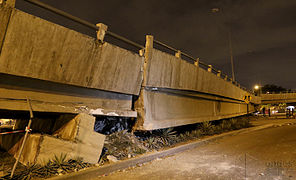
Collapsed bridge ...

... in Guayaquil


Debris on sidewalks ...

... in Guayaquil

Police roadblock in Guayaquil

Blocked road section in the center of Guayaquil

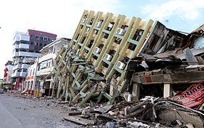
Destroyed building, Guayaquil
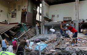
Destruction ...
... in Portoviejo near the coast


.jpg)
.jpg)
.jpg)
.jpg)
.jpg)
.jpg)
.jpg)
.jpg)
.jpg)
See also
Web links
Individual evidence
- ↑ USGS 5j32
- ↑ a b c d M7.8 - 27 km SSE of Muisne, Ecuador ( English ) In: USGS Earthquake Report . April 16, 2016. Retrieved April 17, 2016.
- ↑ Phil Helsel: 7.8-Magnitude Earthquake Hits Near Ecuador's Coast, 28 Dead (English) . In: NBC News , April 16, 2016. Retrieved April 17, 2016.
- ↑ CIFRAS OFICIALES TRAS TERREMOTO EN ECUADOR ( Memento of the original from June 4, 2016 in the Internet Archive ) Info: The archive link was inserted automatically and has not yet been checked. Please check the original and archive link according to the instructions and then remove this notice. Retrieved on June 8, 2016 on El Telegrafo
- ↑ Secretaría de Gestión de Riesgos: SNRG Informe de Situación No. 47 Terremoto en Ecuador al 27 de April 10h00 Terremoto 7.8 ° Muisne on Red de Información Humanitaria para América Latina y el Caribe; Retrieved April 27, 2016
- ↑ 6.8 magnitude earthquake 23 km from Rosa Zarate, Esmeraldas, Ecuador on Earthquake Track, accessed on May 20, 2016
- ↑ 1 Killed, 85 Injured in Strong Aftershock in Ecuador from: China Radio International , May 19, 2016, accessed May 20, 2016
- ↑ International Organization for Migration: IOM Appeal Ecuador Earthquake of April 25, 2016 on Red de Información Humanitaria para América Latina y el Caribe; Retrieved April 26, 2016
- ^ Tsunami Warning Number 1 ( English ) Pacific Tsunami Warning Center. April 17, 2016. Retrieved April 18, 2016.
- ↑ Tsunami Warning Number 3 ( English ) Pacific Tsunami Warning Center. April 17, 2016. Retrieved April 18, 2016.
- ^ Tsunami Warning Number 5 ( English ) Pacific Tsunami Warning Center. April 17, 2016. Retrieved April 18, 2016.
- ↑ 7.8 magnitude earthquake hits near Ecuador, according to USGS ( English ) Associated Press. April 16, 2016. Archived from the original on April 17, 2016. Info: The archive link was inserted automatically and has not yet been checked. Please check the original and archive link according to the instructions and then remove this notice. Retrieved April 17, 2016.
- ↑ South America: More than 300 aftershocks hit Ecuador. In: Spiegel online. April 19, 2016. Retrieved April 19, 2016 .
- ^ 'Considerable damage' in Ecuador following deadly 7.8 quake ( English ) Russia Today. April 16, 2016. Retrieved April 17, 2016.
- ↑ dw.com
- ↑ After earthquake: the number of deaths in Ecuador rises to more than 400 . In: Frankfurter Allgemeine Zeitung . April 19, 2016, ISSN 0174-4909 ( faz.net [accessed April 19, 2016]).
- ↑ Steffen Richter: humedica sends medical team , humedica.org, April 17, 2016.