
Egelsee (Stuttgart)
| Egelsee (Stuttgart) | |
|---|---|
| Surname | Egelsee (also: Around the Egelsee) |
| object | Landscape architecture |
| Water features | Hans Dieter Bohnet |
| Landscape architecture | Hans Luz |
| Construction year | 1992-1993 |
| location | Stuttgart , Wartberg |
| Height above sea level | approx. 280 m |
| Material (water features) | stainless steel |
| Dimensions Egelsee Fontänensee Kugelsee crab tail |
Length approx. 150 m, area approx. 5000 m², diameter approx. 40 m, fountain height approx . 15 m, diameter approx. 30 m, sphere diameter approx. 3.6 m, length approx. 65 m |
| Operating time of the water features | approx. mid-May to mid-October |

The Egelsee is an artificial lake, embedded in an "art garden landscape" on the Wartberg in Stuttgart. The water features of the lake were designed by the sculptor Hans Dieter Bohnet , the landscaping of the site was based on the plans of the landscape architect Hans Luz .
lake
On the slope of the Wartberg, two brooks arise in the west, which flow down to the eastern basin of the Wartberg and merge to form a brook at the Grottenloch art station . This flows into the “crab tail”, a cascade of four ponds that flows into the Egelsee. The lake consists of a long, rectangular basin that nestles in the valley and ends on the narrow sides in two circular lakes, the Kugelsee with a spherical fountain in the west and the Fontänensee with a water organ in the east.
shore
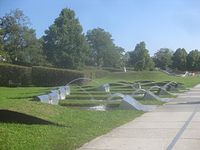
While the south bank of the lake was given a natural look through wild shrubs and a rock fountain, the north bank was designed artificially. The partially modeled ground is covered by lawn, and a continuous water channel rises in a stylized linden grove in the east, which is lined with a succession of lively and playful fountains, bubblers, water batteries and water cannons. Like the Kugelsee and the water organ, they are synchronized by a computer-controlled choreography. The northern edge of the bank is divided into hornbeam chains, which include relaxation areas and fountains.
Art station
The Egelsee art station (also: Around the Egelsee) is one of the art stations that were set up for the 1993 International Horticultural Exhibition (IGA '93) in the green U park in Stuttgart and were retained after the exhibition.
See also: navigation bar art stations in Stuttgart .
In addition to the Egelsee art station, Hans Dieter Bohnet also created the Unter den Stangen and Im Keuper art stations , both on the slope of the Wartberg.
Hints:
- Numbers in brackets, e.g. B. (12), refer to the corresponding numbers in the plan of the Wartberg area.
- Letter abbreviations in brackets, e.g. B. (Ku), refer to the corresponding places in the map of the Egelsee.
location

The Egelsee art station (7) is located in the eastern valley of the Wartberg .
The Wartberg is located in the Stuttgart-Nord district of Stuttgart and functions within the Green U , a closed green space eight kilometers in length, as a link between the Leibfriedschen Garten and Rosensteinpark in the east and the Höhenpark Killesberg in the west.
Note: Keuperbach (12), Stangenbach (13) and Egelbach (14) are not official names, but rather serve to distinguish nameless streams on the Wartberg.
Access
The art station can u. a. can be reached on the following routes (both routes are also suitable for the disabled):
- Direct route: From the Löwentorbrücke tram stop (20), follow the ramp up to the Bombaystegen (21). The left branch of the footbridges leads to the observation bastion (B) on the Egelsee.
- From the source brooks to the Egelsee: Take bus 57 from the Killesberg stop (towards Robert-Bosch-Krankenhaus) or from the Pragsattel stop (towards Killesberg) to the Höhenfreibad stop. At the pedestrian traffic light, on the corner between Stresemannstrasse and Gunterstrasse, turn right into St.-Helens-Weg (19) and follow it to Straßburger Weg (23). This leads parallel to the Keuperbach (12) to the art station Grottenloch (6), where the two source brooks, Keuperbach and Stangenbach (13), join to the Egelbach (14). Follow the Menzel-Bourgiba-Weg (22), which accompanies the Egelbach, and pass the crab tail (Kr) to the Kugelsee (Ku).
prehistory
After the city of Stuttgart had received the bid to organize the IGA '93 in 1984, an ideas and implementation competition was announced in 1986 with the aim of creating a continuous recreational landscape with safe walkways to the neighboring areas between the "tried and tested" listed Rosensteinpark and Höhenpark Killesberg parks To create residential areas and stations of the local public transport lines ”.
The planning group around the landscape architect Hans Luz received the first prize . The jury also applauded the idea of creating an artificial lake in the Wartberg Mulde: "The transition to the Mulde with the main focus of the lake, where the spine formation in front of Volkertstrasse is to be emphasized, is good." The planning group around Hans Luz was founded in 1988 entrusted with the further planning and later with the realization of the Egelsee area. The “previously barely accessible area” with the former Nirk nursery became a “local recreation area”.
"The original idea and essential component of the overall concept, also to clean the roof water of the nearby exhibition halls in a rush-type sewage treatment plant and introduce it into the system, could unfortunately not be implemented." However, the exhibition halls were demolished in 2007, so that this Item of the original planning subsequently done.
"Another important aspect, the aeration " could be implemented "to some extent" through the creation of the crab tail , a cascading sequence of ponds in front of the lake, and the extensive water features that keep the water in constant motion, and thus the lake too give an "important ecological and small-scale climatic sense".
terrain

The Egelsee lies in a hollow into which the Wartberg area runs out to the east. The Wartberg is part of the park landscape of the Green U and lies between the Höhenpark Killesberg in the west and the Rosensteinpark in the east, which was connected to the Wartberg for the IGA '93 via the Leibfriedschen Garten . In front of the IGA, the busy Stresemannstrasse separated the Höhenpark like a dam from the Wartberg; at the IGA, the two parks were connected by two walkways. The Wartberg falls from Stresemannstraße about 60 m to the east to the Wartbergmulde, which ends with the Egelsee. The hollow continues up to Heilbronner Straße, which acts as a barrier to Leibfriedschen Garten, but was also bridged by walkways to the IGA.
lake
The 4,500 m² water surface of the Egelsee “is of particular importance for the park. It is a receiving water for all surface water and is therefore designed as a retention area with a fluctuating water level that can also absorb heavy rainfall. " Water games designed in and around the lake. Thanks to a large number of nozzles, spouts, bubblers and fountains, which form 'an acoustic and optical water symphony', the water is in constant motion and, in addition to its spatial, creative function, together with the water surface, also has its aquatic ecological and small climatological meaning. "
The north bank was redesigned with water features, artificial lawns, avenues and bosquets, the south bank with rock fountains, reeds and perennials at the edge of the bank was redesigned to be natural. Mallards, gray herons, green-footed moorhens and occasionally swans populate the Egelsee and its banks, and water lilies grow and bloom in the lake under the protection of lattice cages.
tour

This section describes the terrain and the water features around the Egelsee. The tour begins at the bastion (B), which can be reached from the Bombaystegen (21), circles the north bank with its water features, turns off at Kugelsee (Ku) and runs along the south bank to Fontänensee (Fo) below the bastion .
bastion
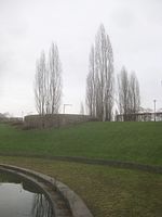
From the Löwentorbrücke tram stop (20), a ramp leads up to the Bombaystegen (21). The left arm of the Bombay footbridges leads through a “gate” made up of three porter poplars to the observation bastion (B) on the Egelsee (see also: Access , path 1). The small viewing platform is supported by a rounded bastion wall. It lies a few meters above the level of the Egelsee area and allows a panoramic view of the lake and the surrounding area.
According to the original plans of the IGA planning group around Hans Luz , "the axis of the bridge [Löwentorbrücke] ... should be aligned with the copper beech over a long, varied meadow of different widths". This line of sight would have enabled a direct view from the bastion to the Bei der Buche art station . The plan failed due to the objection of the ecologists, against which the planning group could not prevail: "But for us planners the elimination of a visually perceptible large meadow to the copper beech and a complicated path system ... still a sad compromise on our basic concept."
Linden grove
The Kairoweg lines the northern bank of the Egelsee. It starts at the bastion (B), first circles the right half of the Fontänensee (Fo), then comes to a corner of the linden grove and continues to the left in a straight line along the north bank of the Egelsee.
The square of the linden grove is divided into three strip-shaped plateaus that run transversely to the longitudinal axis of the Egelsee and are connected across the entire width with five-step stairs. On the plateaus tall globular linden trees line up to form a four-lane avenue, in which stool-like concrete cylinders invite you to relax in the shade of the trees here and there.
Gully
On the right edge of the linden grove, an artificial spring rises from a beak-shaped stainless steel plate, which pours into a circular basin and then flows in a channel to the end of the linden grove and meets the Kairoweg there. The water channel (W) is flanked on both sides by a wide footpath. Stainless steel walls with an amoeba- shaped outline bridge the transitions on the stairs like railings.
The walls are connected to each other by a stainless steel band embedded in the floor, which continues at the end of the water channel on the Kairoweg to Kugelsee (Ku) and divides the path into two strips. The tape marks the course of the water channel, which continues underground, and at the same time part of the visual axis, which starts at the source of the water channel and intersects with a second visual axis in the Kugelsee, which is the longitudinal axis of the Bombay footbridges (21) and the bastion (B) begins and runs lengthways across the lake.
Bastion.
Water channel, from the source to the Kugelsee.

Linden grove with water channel.

Fountain lake and underwater battery (left behind the fountain).


Underwater battery
On the narrow side of the Egelsee, opposite the Kugelsee, an underwater battery (Uuw) with 13 water cannons is installed, which shoot their water in a high arc in the direction of Kugelsee (Ku). Currently only five of the 13 cannons are functional (as of August 2016).
Turf pyramid
Following the linden grove, to the right of the Kairoweg, you will come across the lawn pyramid (Rp), a five-tier, turf-covered step pyramid with a side length of approx. 11 m. It consists of five square boxes placed one on top of the other, which are filled with earth and whose sides decrease from step to step. Each box is framed by rust-brown steel sheets and is planted with lawn, so that the pyramid hardly differs from its surroundings from a bird's eye view.
The rear quarter is “cut out” of the pyramid and moved diagonally backwards so that a right-angled passage is created between the two parts of the pyramid. The inner walls of the passage are lined with stainless steel plates, which are terminated with handrails. These are crowned by handrail-like stainless steel tubes that form two parallel arrow shapes and point with their tips towards the lake.
In the corner of the passageway, a fountain from over 20 nozzles used to radiate vertical fountains into the air; however, this part of the pyramid seems to have been shut down - at least temporarily. On the middle three steps of the inner walls there are water chutes at step height (12 in total), which pour the water out of a slot like a waterfall onto the gravel path of the passage. From there, the water flows outward into the shallow ditch that surrounds the pyramid, finally collects at the front tip of the pyramid and flows down to the Egelsee. At Kairoweg, the water flows under a grid so that walkers can continue on their way with dry feet, and then pours over a multi-step staircase into the Egelsee. The step motif of the pyramid is taken up by a three-step lawn staircase that flanks the drainage channel on both sides. A circular stainless steel disc rises on the middle step of the drainage channel, which shoots its water into the lake as a water cannon.
Today the lawn pyramid is closed as a well and the channel is filled with sand; Water will no longer flow here. The water staircase leading to the Egelsee, however, continues to be operated by a separate water supply.

Lawn pyramid, from the south bank of the Egelsee.

Lawn pyramid, from the north bank of the Egelsee.
Lawn pyramid, from the linden grove.

Front: water cannon by the lawn pyramid.


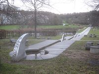
Snake
A three-part snake (Sc) made of thick stainless steel pipes with a total length of approx. 20 m follows the lawn pyramid. Its tail section rises like a high archway from the earth and curls itself at the other end at ground level towards the middle section, which after a short interruption resumes movement and sinks into the earth in a gentler and lower arc. The third fragment of the snake crawls a short distance over the ground and then rears up almost vertically just before the Kairoweg. From a nozzle at the mouth of this pipe the snake spits a jet of water in a high arc over the Kairoweg into the Egelsee. The resulting mist is a pleasant refreshment for many passers-by in summer.
The snake is now, as in previous years, shut down; only in 2015 was it in operation for about half a year. It turned out that due to the excessive scattering of the jet at the outlet opening, the entire path as well as the lawn area around the snake was flooded. This posed a problem, as both the Kairoweg and the connection route from the area to the adjacent Volkerstraße, which is located in the flooded area, are heavily frequented by passers-by. The turf construction of the water cannon at the height of the turf pyramid (Rp) was also affected by the constant irrigation by the snake, so that no more grass grew there.
Grass mound
As the next object, a dome-shaped, round hill (Rh) with a diameter of approx. 20 m rises from the lawn, which, on closer inspection, turns out to be a turf-planted ring wall because it is hollow on the inside. A wide canal leads to it from Kairoweg, which is flanked on both sides by a narrow pedestrian path. At the mouth of the canal, the ring wall is broken through and is crowned on both sides by a railing-like, curved steel tube.
The interior of the ring wall is designed like an amphitheater . A ring-shaped, four-step stepped spectator stand made of concrete blocks surrounds the inner round. A shark fin made of stainless steel divides the upper tiers of the grandstand in half and protrudes above them like a trophy . In the center of the mound of grass, three fountains surprisingly explode at longer intervals, which are especially fun for children.
The water flows through the channel under the Kairoweg into the lake. A water cannon is installed at the entrance of the canal into the lake, which shoots its water in unison with the snake (Sc) and the bank-side cannons of the bank battery (Uf) and fought a battle with the contrary jet of the now disused rock well (Fe).

Snake.

Turf hill, from the south bank of the Egelsee.

Turf hill, view from inside to the lake, behind: water cannon.

Mound of grass, looking inside at the grandstand.


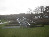
Pyramid pillar
The pyramid column (P, back) and the bank battery (Uf, front) follow the turf hill. The pyramid column forms the center of a U-shaped boscette enclosure with benches on the sides to relax and watch the water feature. The dominant shape of the pyramidal pillar is the equilateral triangle. It protrudes from a triangular water basin, the corners of which are covered with double pyramids made of stainless steel, and is made up of seven double pyramids, also made of stainless steel, placed one on top of the other. Since the column is currently (2016) not in operation, one can only assume that the water gushed out of the top of the column earlier and trickled down along the column into the basin. When the sunlight is incident, there are interesting light reflections, some triangular surfaces then shine like headlights in glistening light. The pyramid column is currently not functional (as of August 2016).
Shore batteries
The bank batteries (Uf) are installed in front of the enclosure of the pyramid column (P). They extend on both sides of the Kairoweg. The battery on the embankment consists of five water cannons arranged side by side in stainless steel boxes, which shoot their rays into the lake in a high arc in unison with the pyramid and grass hill cannons. Currently none of the five cannons is operational (as of July 2017).
The battery on the other side of Kairoweg is flanked by artificial turf waves that are supported on the sides by rust-brown steel sheets. In five rectangular collecting basins, separated by strips of lawn, there are each a water chute (directly on Kairoweg) and a water cannon (towards the pyramid column), which, as if in dialogue with one another, pour or shoot their water from stainless steel housings similar to prompter into the basin. These five batteries, not one of which is currently (2017) in operation, are usually the only system that remains in action during the breaks between the programmed water features.
Pyramid pillar.
Bank batteries between Kairoweg and the pyramid column.

Bank battery on the bank embankment.

Bank batteries, general view.


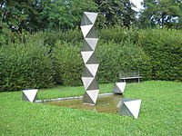
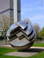
Kugelsee
Two round lakes mark the beginning and end of the Egelsee: the Fontänensee (Fo) and the Kugelsee (Ku). Along with the Fontänensee, the Kugelsee is one of the two main attractions of the water features at the Egelsee Art Station. In the center of the Kugelsee, which measures approx. 30 m in diameter, there is a spherical fountain object by Hans Dieter Bohnet. The spherical object lies at the meeting point of two lines of sight that lead the view over the entire length of the Wartberg hollow:
- One axis starts from the source of the water channel (W), runs in a straight line through the water channel, then parallel to the north bank along the stainless steel strip that marks the underground continuation of the water channel, and ends in the Kugelsee.
- The other axis begins with the longitudinal axis of the Bombay bridges (21) at the bastion (B) and runs lengthways over the rectangular area of the Egelsee to the Kugelsee.
Unlike the Fontänensee, the Kugelsee is apparently not a direct extension of the Egelsee because the connection between the two is covered by a wide footbridge, the Kugelseesteg. Seven narrow channels run through this path, through which the water of the Kugelsee flows into the Egelsee.
Many of Hans Dieter Bohnet's art objects are based on “the sphere as the most perfect geometric shape”. "He cuts them up, divides them and puts them back together again in a different order". The spherical object of the spherical lake has a diameter of 3.60 m and consists of three quarter spheres made of stainless steel. The base of the object forms an approximately 30 0 inclined ball quarter, which rests on a thick standpipe in the center of the lake. The other two quarter ball sitting on the two flat faces of the first sectional area, however, each by about 30 0 turned against each other, so that between them a gap on two sides. Through this gap you can see into the interior of the sphere, where a small sphere is located in its center, which with its spray nozzles shoots up a vertical column of water or fan-like fountains at intervals.
As early as 1977, a much-noticed spherical object by Hans Dieter Bohnet was presented at the Federal Garden Show in the lower palace garden , which bears a certain resemblance to the spherical fountain. The object originally “designed for the Federal Chancellery in Bonn and rejected [by Helmut Schmidt ] then did not stay in Stuttgart, but was later set up on the banks of the Rhine in Bonn in front of the Lange Eugen ”.

Kugelsee, view of the Bülow Tower on Heilbronner Strasse.

Kugelsee, view of the Wartberg slope

Kugelseesteg, left: Kugelsee, right: Egelseeufer.

Sphere object with heron.
Sphere object by Hans Dieter Bohnet in front of the Tall Eugen in Bonn, 1976.


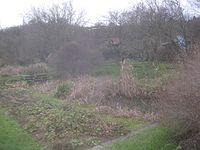
Crab tail
The “crab tail” seems to form the tail of the Egelsee, in fact it does not form its outlet, but is in front of it. The series of elongated ponds, staggered in height and size, is located at the foot of the allotment gardens of the Wartberg and supplies the Kugelsee (Ku) and thus the Egelsee with water. The uppermost of the ponds is fed by the Egelbach (14), which arises in the Grottenloch from the merger of the two Wartberg brooks Keuperbach (12) and Stangenbach (13).
The ponds, lying in a meadow landscape, are hidden from the eye of the passer-by because they are densely enveloped by shrubbery and water plants. Between the ponds, narrow, grass-covered footbridges lead to the other side and stairs made of roughly hewn natural stone lead into the pond below.
Like the water features, the crab tail also serves to aerate the Egelsee and thus fulfills an “important ecological and micro-climatic sense”.

Crab tail (in autumn).
Crab tail single pond (in autumn).

Staircase between two ponds of crab tail (in summer).

Rock fountain.


Kugelseesteg
The Kugelsee (Ku) closes the artificially designed north bank of the Egelsee. The Kugelseesteg, which separates the Kugelsee and the Egelsee from each other and creates the connection between Kairoweg (north bank) and Menzel-Bourgiba-Weg (south bank), leads to the natural or designed south bank. You first come across the "triangle", a triangular island between the two arms of the connecting path between Kugelseesteg and Menzel-Bourgiba-Weg. It is planted with two triangular hornbeam rosettes that open a passage between the two.
Rock fountain
Almost at the other end of the south bank, near the Fontänensee (Fo), the Felsenbrunnen (Fe) used to shoot its fountain into the Egelsee. Since the south bank was to be designed in a natural way, two natural rocks were erected, which hide the stainless steel pipe between them, from which the water jet once shot into the air. The rock fountain has been closed since 2013.
Fountain lake
Two round lakes mark the beginning and end of the Egelsee: the Fontänensee (Fo) and the Kugelsee (Ku). The water features of the two lakes are the main attractions of the Egelsee art station, whereby the Fontänensee with its water organ offers the richest water play program. The round Fontänensee is connected to the southeast corner of the rectangular Egelsee. One of the two visual axes of the Egelsee area, which begins at the Bombaystegen (21) and the bastion (B), leads through the center of the Fontänensee, crosses the Egelsee diagonally and ends in the center of the Kugelsee. The Fontänensee is surrounded by a narrow ring of lawn, which is separated by a massive, bench-like edge stone from the slope behind it, which itself ends in a semicircle.
A concrete plate in the middle of the Fontänensee hides a multitude of nozzles which, with their foam bubblers and their up to 15 m high fountains, unfold a colorful program of water features in a computer-controlled choreography and throw "flower-like patterns" into the water. At the moment (2016) not all nozzles - such as the funnel, which is located exactly in the middle of the platform - are functional.


Names
Egelsee
The Egelsee art station was originally called Donars Stich in the internal parlance of the IGA planning group headed by Hans Luz , in a joking allusion to the Thursday meetings of the Stuttgart City Council, which had given the majority approval for the garden show to be held. The vote at that time was reflected not only verbally but also allegorically in the design of the lake shores: the north shore with its stainless steel installations stands for the groups that had voted for the garden show, the south shore with a rock fountain and wild perennials for the Greens who voted against it .
The new artificial lake was finally given its official name in reference to an older lake of the same name, which was located in a swampy area on the Prague , and where the "Stuttgarters got their leeches - against heart attacks and other ailments". The Egelsee on the Prague, on the other hand, should not be confused with the legendary Egelsee in today's city center of Stuttgart, which is mentioned in the legend The Blood Tower in the Nesenbachtal .
Paths and footbridges
Paths and footbridges on the Wartberg and at the transitions to the Höhenpark Killesberg and Leibfriedschen Garten were not named according to old field names or other location-related criteria, they rather have artificial names that may seem strange at first glance. Instead of adopting the names created by the IGA planning group, a commission decided to name the paths and footbridges after partner cities. This is how names such as St.-Helens-Weg, Kairoweg, Menzel-Bourgiba-Weg, Bombaystege etc. came about. The name of the Löwentorbrücke underground station seems to be a relic from the time before the partner city was named, probably for practical reasons renamed the stop in "Bombaystege" waived.
concept
Hans Dieter Bohnet based the design of the Egelsee area on the following considerations:
- “As a transition from the urban part via technically shaped bridge structures to the scenic, natural area of the Wartberg, a bank of the newly created Egelsee is artificially created.
- As an important station on the long way from Schloßplatz via Rosenstein to Killesberg, this area experiences a creative consolidation in which sculptural elements are integrated into the landscape architecture.
- Simple ground sculptures such as the strictly built lawn pyramid, the softer lawn mound and the fading lawn waves structure the continuously paved lawn area.
- Two visual axes are decisive for the design area: one in continuation of the longitudinal axis of the bridge over the bastion and water island, the other from the source in the linden grove - clearly marked as a trace in the riverside path - to the intersection of the axes where the slowly rotating spherical object appears as the final accent.
- Water is involved in all parts in different ways. The formless material water is given shape by the water features. They appear as a spatial graphic addition and animation in a certain period and in a recurring rhythm.
- Changing constellations, sequences of actions and movements from dialogue to chaos should be made visible. "
literature
- Ralf Arbogast: Stuttgart, the green experience. Recreational landscapes, parks and garden shows in the past and present , Tübingen 1993.
- Rebekka Bücheler: Hans Dieter Bohnet, Kubus 1978 . In: Elisabeth Szymczyk-Eggert: Gardens and Parks in Stuttgart , Stuttgart 1993, pp. 74–77, here: 76.
- Egelsee I . In: Helmut Dölker: The field names of the city of Stuttgart. The names of the city center and the districts of Berg, Gablenberg and Heslach. Reprint of the 1933 edition, supplemented by 41 illustrations and 2 maps , Stuttgart 1982, No. 441, pp. 280–281.
- Rolf Fischer: Stuttgart and the Green U. The park landscape from Killesberg to the castle gardens , Stuttgart 2003, pp. 18–95, here: 78–81, 85–87.
- Christoph Gunßer: The international horticultural exhibition Iga Expo '93 in Stuttgart . In: Deutsche Bauzeitung db. Journal for architects and civil engineers , 127.1993, issue 6, pp. 14–28, here: 6–7, 26.
- Hans Kammerer: HD Bohnet, sculptor. Exhibition in the Städtische Galerie Böblingen, 2.5. - 20.6.1993 . Boeblingen 1993, pp. 94-95.
- The IGA is changing the north . In: Jörg Kurz; Edgar Dambacher (contributions): Northern history (s). On the living and life of people in the north of Stuttgart , [Stuttgart] 2005, p. 113.
- Christof Luz; Hans Luz: overall planning time systems: The Green U . In: Garten + Landschaft 103.1993, Issue 7, pp. 18–28, here: 20, 22–24.
- Christof Luz; Hans Luz: Planning concept. Landscaping . In: Klaus-Jürgen Evert (editor): The permanent systems. IGA Stuttgart 1993 , Munich 1993, pp. 12-17, here: 13-14, 17.
- Hans Luz: From Vorgartenmäuerle to Green U. Forty years of landscape gardener. A work report by Hans Luz , Stuttgart 1992.
- Hans Luz: Planning and design of the permanent systems . In: Building for Agriculture 1993, Issue 1, pp. 8–18, here: 6, 7, 9, 10.
- Hans Luz: Wartberg / Steinberg and Leibfriedscher Garden . In: Elisabeth Szymczyk-Eggert: Gardens and Parks in Stuttgart , Stuttgart 1993, pp. 100–105, here: 101.
- Hans Luz: Around the Green U . Manuscript, Stuttgart 2012.
- Heiner Luz: Tree grids and perennials : Plant planning for permanent plants . In: Garten + Landschaft , 103.1993, issue 7, pp. 29–31, here: 29, 30.
- Joachim Ramlow (editor): IGA Stuttgart Expo 93: Booklet with a program for the IGA and the Athletics World Championships, special exhibitions in museums, cultural and leisure tips, gastronomy . Stuttgart 1993, p. 13.
- Georg Schiel: International Horticultural Exhibition 1993 in Stuttgart. Open ideas and implementation competition . In: Garten + Landschaft , 97.1987, issue 6, pp. 27–32.
- Georg Schiel: planning competition . In: Klaus-Jürgen Evert (editor): The permanent systems. IGA Stuttgart 1993 . Munich 1993, pp. 8-12.
- City of Stuttgart (Ed.): Egelsee water games . stuttgart.de accessed in 2013.
- City of Stuttgart (Ed.): Hans Dieter Bohnet: Kugelobjekt, 1993 . stuttgart.de accessed in 2013.
- Frank R. Werner: Landscape and Art . In: Klaus-Jürgen Evert (editor): The permanent systems. IGA Stuttgart 1993 . Munich 1993, pp. 26–30, here: p. 26.
- Frank Werner (ed.); Christof Luz (essay); Hans Luz (essay): Art-Nature-Drama. Earthworks beyond the IGA 1993 Stuttgart . Stuttgart 1993, [57].
Web links
- Egelsee water features . Website of the city of Stuttgart
- Hans Dieter Bohnet: Sphere Object, 1993 . Website of the city of Stuttgart
- Egelsee Park . Metropolitain, photo gallery
- Egelsee Stuttgart , hang gliding pictures. Status: March / April 2011.
- Topographic map, hybrid map and aerial photos on a scale of 1: 500, city map Stuttgart , search term: Wartberg.
Individual evidence
- ↑ Length including Fontänensee, excluding Kugelsee and crab tail.
- ^ Area including Fontänensee, excluding Kugelsee and crab tail.
- ↑ #Stuttgart 2013.2 .
- ↑ a b c The plan is based on an OpenStreetMap map.
- ↑ #Arbogast 1993 , p. 84.
- ↑ #Schiel 1987 , p. 28.
- ↑ #Schiel 1993 , p. 11.
- ↑ #Short 2005 .
- ↑ a b #Christof Luz 1993.1 , p. 23.
- ↑ a b #Christof Luz 1993.1 , pp. 23-24.
- ↑ #Stuttgart 2013.1 .
- ↑ #Christof Luz 1993.3 , p. 14.
- ↑ #Hans Luz2012 , p. 67.
- ↑ a b # Werner 1993.3 , p. [57].
- ↑ a b Figure in action: #Hans Luz1992, p. 156 .
- ↑ a b # Bücheler 2006 , p. 76.
- ↑ Illustration of the model: #Kammerer 1993 , p. 94.
- ↑ #Hans Luz1992 , pp. 130-131.
- ↑ Keuperbach, Stangenbach and Egelbach are not official names, but are used here to differentiate between the nameless streams.
- ↑ #Hans Luz2012 , p. 73, #Hans Luz 1993.3 , p. 102.
- ↑ #Hans Luz2012 , p. 73.
- ↑ # Dölker 1933 , #Hans Luz2012 , p. 73.
- ↑ Stuttgart legends I. The blood tower in the Nesenbachtal.
- ↑ #Hans Luz2012 , p. 77.
Coordinates: 48 ° 48 ′ 16.1 ″ N , 9 ° 10 ′ 54.5 ″ E
