Elbow Lake
| Elbow Lake | ||
|---|---|---|

|
||
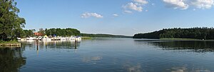
| The Ellbogensee at the mouth of the Havel near Priepert | ||
| Geographical location | District of Mecklenburg Lake District , Mecklenburg-Western Pomerania | |
| Tributaries | Havel ( Großer Priepertsee ) and Elde via Müritz-Havel waterway | |
| Drain | Havel ( Ziernsee ) | |
| Places on the shore | Priepert , Grossmenow | |
| Data | ||
| Coordinates | 53 ° 12 '26 " N , 13 ° 2' 15" E | |
|
|
||
| Altitude above sea level | 54.8 m above sea level NHN | |
| surface | 1.55 km² | |
| Maximum depth | > 17 m | |
The Ellbogensee is located in the Mecklenburg Lake District 16 kilometers south of Neustrelitz . It is about 5.5 kilometers long and up to 500 meters wide and belongs to the Neustrelitzer Kleinseenland in Mecklenburg-Western Pomerania . The southeast bank forms the border with the state of Brandenburg .
The lake lies in the municipal areas of Priepert and the city of Wesenberg . At the northern tip, at the transition from the Großer Priepertsee , is the place Priepert and a little to the west of the westernmost lake point of the Wesenberg district Strasen . The narrow lake has a distinctive z-shape, from which its name is probably derived. It is divided into three basins: north basin, north-south basin and south basin. The deepest part of the lake is in the north basin. There is a campsite on the south bank near Großmenow .
The lake receives its tributaries in the north from the Havel (Großer Priepertsee) and in the west via an approximately 1 km long canal with the Strasen lock from the Großer Pälitzsee and ultimately from the Elde via the Müritz-Havel waterway . The Strasen lock was built in 1845 and has a fall height of 1.42 meters to the east to the valley. The Havel flows further east from the southern basin of the Ellbogensee into the Ziernsee.
The north basin from the west to Priepert is part of the 32-kilometer-long federal waterway Müritz-Havel waterway, which joins the federal waterway Obere Havel waterway at km 0 , to which the other two basins of the Ellbogensee belong. Both federal waterways belong to waterway class I, for which the Eberswalde Waterways and Shipping Office is responsible.
See also
Individual evidence
- ↑ Directory E, Ser. No. 36 of the Chronicle ( Memento of the original from July 22, 2016 in the Internet Archive ) Info: The archive link was inserted automatically and has not yet been checked. Please check the original and archive link according to the instructions and then remove this notice. , Federal Waterways and Shipping Administration
- ↑ Lengths (in km) of the main shipping lanes (main routes and certain secondary routes) of the federal inland waterways ( memento of the original from January 21, 2016 in the Internet Archive ) Info: The archive link was inserted automatically and has not yet been checked. Please check the original and archive link according to the instructions and then remove this notice. , Federal Waterways and Shipping Administration
- ↑ Directory E, Ser. No. 39 of the Chronicle ( Memento of the original from July 22, 2016 in the Internet Archive ) Info: The archive link was inserted automatically and has not yet been checked. Please check the original and archive link according to the instructions and then remove this notice. , Federal Waterways and Shipping Administration
