
Engwierum
 flag |
 coat of arms |
| province |
|
| local community | Noardeast-Fryslân |
|
Area - land - water |
12.32 km 2 11.57 km 2 0.75 km 2 |
| Residents | 520 (Jan. 1, 2017) |
| Coordinates | 53 ° 19 ′ N , 6 ° 8 ′ E |
| height | 2 m NAP |
| Important traffic route |
|
| prefix | 0511 |
| Postcodes | 9131-9133, 9291, 9294, 9976 |
| Website | Homepage of Engwierum |
Engwierum ( West Frisian Ingwierrum ) is a village in the municipality of Noardeast-Fryslân in the Dutch province of Friesland . It is located east of Dokkum and has 520 inhabitants (as of January 1, 2017). It borders the Lauwersmeer National Park .
The name Engwierum probably comes from Edingawerum. Thus were mounds called on which the Edinga, a family lived.
Picture gallery
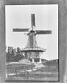
Windmill (around 1913)
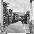
Engwierum (around 1920)
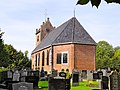
Church (2010)
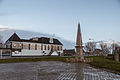
Monument (2013)

Dokkumer Grutdjip (also: Dokkumer Grootdiep ) near Engwierum (2010)

De Dobbe 2 (2010)


Web links
Commons : Engwierum - collection of images, videos and audio files
- Place website (Dutch)
- Information on Engwierum In: friesland-digitaal.eu (Dutch)
Individual evidence
- ↑ a b Kerncijfers wijken en buurten 2017 Centraal Bureau voor de Statistiek , accessed on June 16, 2018 (Dutch)