Eufaula, Alabama
| Eufaula | |
|---|---|
 Gov. Chauncy Sparks House (2011) |
|
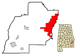
| Location in County and Alabama | |
| Basic data | |
| Foundation : | 1834 |
| State : | United States |
| State : | Alabama |
| County : | Barbour County |
| Coordinates : | 31 ° 53 ′ N , 85 ° 9 ′ W |
| Time zone : | Central ( UTC − 6 / −5 ) |
| Residents : | 13,600 (as of 2004) |
| Population density : | 88.4 inhabitants per km 2 |
| Area : | 190.3 km 2 (approx. 73 mi 2 ) of which 153.9 km 2 (approx. 59 mi 2 ) are land |
| Height : | 80 m |
| Postcodes : | 36027, 36072 |
| Area code : | +1 334 |
| FIPS : | 01-24568 |
| GNIS ID : | 0118051 |
Eufaula is a city in Barbour County in the US state of Alabama . It has about 13,600 inhabitants (as of 2004) on an area of 190.3 km². The city is located at the geographical coordinates of 31.91 ° North, 85.15 ° West.
history
14 structures and sites in Eufaula are registered in the National Register of Historic Places (NRHP) (as of July 3, 2019), including the Gov. Chauncy Sparks House and the Lore Historic District .
sons and daughters of the town
- Walter Kehoe (1870–1938), politician
- Edwin E. Floyd (1924–1990), mathematician
- Johnie Lewis (1908-1992), blues musician
- Martha Reeves (* 1941), soul singer
- Rick Lowe (born 1961), artist
- Courtney Upshaw (born 1989), American football player
Web links
Commons : Eufaula, Alabama - Collection of Images, Videos, and Audio Files
- Eufaula in the Encyclopedia of Alabama
Individual evidence
-
↑ Search mask database in the National Register Information System. National Park Service , accessed July 3, 2019.
Weekly List on the National Register Information System. National Park Service , accessed July 3, 2019.
