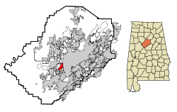
Fairfield, Alabama
| Fairfield | |
|---|---|
|
Location in county and state
|
|
| Basic data | |
| Foundation : | 1910 |
| State : | United States |
| State : | Alabama |
| County : | Jefferson County |
| Coordinates : | 33 ° 29 ′ N , 86 ° 55 ′ W |
| Time zone : | Central ( UTC − 6 / −5 ) |
| Residents : | 11,696 (as of 2005) |
| Population density : | 1,271.3 inhabitants per km 2 |
| Area : | 9.2 km 2 (approx. 4 mi 2 ) of which 9.2 km 2 (approx. 4 mi 2 ) is land |
| Height : | 171 m |
| Postal code : | 35064 |
| Area code : | +1 205 |
| FIPS : | 01-25120 |
| GNIS ID : | 0118113 |
Fairfield is a city in west Jefferson County in Alabama , USA . The place is southeast of Pleasant Grove, Alabama . The total area of the place is 9.1 km². The United States Census 2010 counted 11,117 residents.
history
The city was founded in 1910 and was originally named after a board member of the US Steel Corey . The name was later changed to Fairfield , after Fairfield, Connecticut , the city where the President of US Steel lived. The town was planned as a planned town by the Tennessee Coal, Iron and Railroad Company to house workers from their new factory, now owned by US Steel.
Demographics
| Population development | |||
|---|---|---|---|
| Census | Residents | ± in% | |
| 1920 | 5003 | - | |
| 1930 | 11,059 | 121% | |
| 1940 | 11,703 | 5.8% | |
| 1950 | 13,177 | 12.6% | |
| 1960 | 15,816 | 20% | |
| 1970 | 14,369 | -9.1% | |
| 1980 | 13,242 | -7.8% | |
| 1990 | 12,200 | -7.9% | |
| 2000 | 12,381 | 1.5% | |
| 2010 | 11,117 | -10.2% | |
| 2012 estimate | 11,029 | -0.8% | |
|
US Decennial Census
2012 Estimate |
|||
At the 2000 census, Fairfield had 12,381 residents, distributed among 4,600 households and 3,141 families. The population density was thus 1354.2 inhabitants / km². 90.23% of the population were African American and 8.9% were white. Children under the age of 18 lived in 34% of households. The median income per household was $ 27,845, with 21.5% of the population living below the poverty line .
education
Fairfield has its own school system independent of Jefferson County. It includes three elementary schools, Forest Hills Middle School , Fairfield High Preparatory School, and an alternative school spanning all grades. Miles College is also in town, a historic African American college run by the Christian Methodist Episcopal Church and founded in 1898.
Industry and commerce

Although the US steel industry went through a period of depression in the last half of the 20th century , US Steel's Fairfield Mills continued to be the largest employer, though not as much as it was in the 1950s. Advances in the steel industry made it possible to produce roughly the same amount of goods with far fewer workers than in the 1950s. Some of the plants have closed over the years, but much of the complex has been reopened by smaller firms, some of which are in the steel industry. Fairfield is crossed by I-20 and I-59 . Three rail lines service the region: the CSX Transportation (formerly Louisville and Nashville Railroad ), the Norfolk Southern Railway (formerly Southern Railway ) and the short Birmingham Terminal Railway , which is headquartered in Fairfield. There are a few small shops in downtown Fairfield, mostly service providers. Other retail stores can be found on Aronov Drive, northwest of the Western Hills Mall, although these strip malls are no longer doing so much due to the closings of Kmart , Winn-Dixie and Sears stores.
Famous pepole
- Willie Mays (* 1931) attended school in Fairfield and graduated from Fairfield Industrial High School in 1950. As a student he played baseball , American football and basketball . He even played professionally for the Birmingham Black Barons in the Negro American League .
- The actor George Lindsey (1928–2012) (" Andy Griffith Show ") was born in Fairfield.
- The jazz musician Cleveland Eaton (1939-2020) (" Count Basie Orchestra ") was born in Fairfield.
- The singer Dennis Edwards (1943-2018), a member of The Temptations , was born in Fairfield.
- The photographer Spider Martin was born in Fairfield.
- Larry Langford (1948-2019), the former Mayor of Fairfield, County Commissioner of Jefferson County and Mayor of Birmingham lived in Fairfield.
- James MacKay (1919-2004), Georgia Congressman and environmental activist, was born in Fairfield.
- Red Cochran and Jim Tolbert , former players in the NFL , were born in Fairfield.
- This also applies to Gordon Douglas Jones (* 1954), who was elected Senator of the United States in the by-election on December 12, 2017 in Alabama .
- Judge UW Clemon was born in Fairfield.
- Mayor AD Oliver W. Dillard , left Fairfield Industrial High School as the final speaker in 1942.
- Walter Gilbert (* 1932), member of the College Football Hall of Fame
- Tim Johnson , former professional linebacker
- Demetrius Newton , civil rights lawyer and member of the Alabama House of Representatives
swell
Individual evidence
- ↑ United States Census Bureau : Census of Population and Housing . Retrieved August 10, 2013.
- ↑ Annual Estimates of the Resident Population: April 1, 2010 to July 1, 2012 . Retrieved August 10, 2013.
