European Canal (Regensburg)
| European channel | ||
|
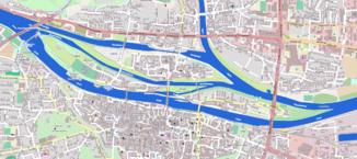
The Europakanal lies north of the main Danube river |
||
| Data | ||
| location | Regensburg , Upper Palatinate , Bavaria , Germany | |
| River system | Danube | |
| origin | Junction from the Danube 49 ° 1 ′ 46 ″ N , 12 ° 4 ′ 36 ″ E |
|
| muzzle | in the rain shortly before its confluence with the Danube Coordinates: 49 ° 1 '34 " N , 12 ° 6' 11" E 49 ° 1 '34 " N , 12 ° 6' 11" E
|
|
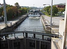
The European channel in Regensburg is its function after the lock channel Regensburg with the lock Regensburg the impounded here federal waterway Danube . At the time of construction, the canal was also called the Rhine-Main-Danube Canal .
Location and technical data
The lock chamber is 190 meters long and 12 meters wide. It is located on river kilometer 2379.7. The drop height of the lock is 5.20 m. This northern bypass of the main river of the Danube was built in 1972–1978, taking into account the stone arch bridge that has existed since 1146 . As a section of the European shipping route from the North Sea to the Black Sea , this canal was given the local name European Canal. In the west of the Stadtamhof district at km 2381.22 it branches off from the main river of the Danube and in the east at km 2379.24 it joins the rain , 420 m above its confluence with the northern arm of the Danube. The bypass route of the Danube in the urban area of Regensburg has a length of around two kilometers.
Stadtamhof has been separated from the Steinweg district to the north since the canal was built . For this reason, Stadtamhof has since been referred to as an island by some sources.
bridges
Two road bridges and a pedestrian bridge cross the canal. At the eastern end of the canal, directly below the lock, is the Protzenweiher Bridge , which was built at the same time as the canal was built. The Upper Palatinate Bridge connects the Steinweg district with Stadtamhof further west and a pedestrian bridge was built near the Regensburg power plant , at the beginning of the European Canal in the west.
history
The first plans for the expansion of the Danube for shipping in Regensburg were made in the 1930s. The so-called Protzenweiher was a damp ditch that was only flooded by the river during floods. This trench was replaced by the construction of the canal.
The Europakanal brings with it urban planning challenges. From its branch to the lock, the canal is higher than the natural land level.
literature
- M. Eckoldt (Ed.), Rivers and Canals, The History of German Waterways, DSV-Verlag 1998
Individual evidence
- ↑ a b Lengths (in km) of the main shipping lanes (main routes and certain secondary routes) of the federal inland waterways ( Memento of the original from January 21, 2016 in the Internet Archive ) Info: The archive link was automatically inserted and not yet checked. Please check the original and archive link according to the instructions and then remove this notice. , Federal Waterways and Shipping Administration
- ↑ Two kilometers of the Danube alternative road . Central Bavarian Newspaper . Retrieved August 7, 2014.
- ^ Daniela Schetar, Friedrich Köthe and Peter Hirth: DuMont Bildatlas Bayerischer Wald. P. 33. (online at Google Books : [1] )
- ↑ Aschaffenburg Waterway Construction Office: Protzenweiherbrücke ( page no longer available , search in web archives ) Info: The link was automatically marked as defective. Please check the link according to the instructions and then remove this notice.
- ↑ City of Regensburg ( page no longer available , search in web archives ) Info: The link was automatically marked as defective. Please check the link according to the instructions and then remove this notice.


