
FFH area Hasenmoor
|
FFH area Hasenmoor
|
||
 |
||
| location | Hasenmoor municipality , Segeberg district , Schleswig-Holstein , Germany, approx. 8 km east of Bad Bramstedt | |
| surface | 275 ha | |
| Identifier | 2025-303 | |
| WDPA ID | 555518001 | |
| Natura 2000 ID | DE2025303 | |
| Geographical location | 53 ° 56 ' N , 10 ° 0' E | |
|
||
| Setup date | 2007 | |
| administration | LLUR | |

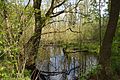
In the region, the Hasenmoor FFH area is called the Königsmoor. The Hasenmoor is a formerly large raised bog in the Holstein Vorgeest , which today has partly transitional bog character as a result of industrial peat extraction and subsequent renaturation .
In terms of nature, the area is part of the Holstein Vorgeest natural area, within the Atlantic biogeographical region . The Holstein Vorgeest provides a between the Moränengebieten of Holstein hills and the High Geest preferred, slightly inclined to the west Sander landscape . The fluvioglacial gravels and sands were from meltwater the Weichselian temporal deposited glaciers and are typical of the middle back Schleswig-Holstein. The Hasenmoor is the remainder of an originally 600 hectare high rainwater moor of the Holstein Vorgeest, which drains into the Stör via Holmau and Osterau . One on the ground Sander has raised bog complex with Torfmächtigkeiten from an average of four formed. In the last century, the Hasenmoor formed a scenic unit with the Stellbrook , Langloher , Holmer and Halloher Moor, supplemented by heaths .
In terms of peat , the Hasenmoor can be subdivided into a southwestern and a northeastern part. While the peat in the southwest was quarried for personal use using the manual peat digging process, the northeast is characterized by industrial quarrying that took place until the 1970s.
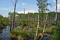
Stages of pipe grass degeneration and birch stages of raised bog degeneration are widespread in Hasenmoor. However, these are very different. Common to all areas is the imprinting of pipe grass ( Molinia caerulea ) and bog birch ( Betula pubescens ). In some places there are hardly any species of upland moor to be found, whereas mineralization and ruderal indicators such as z. B. Blackberries ( Rubus fruticosus agg.), Bracken ( Pteridium aquilinum ), arable and swamp thistle ( Cirsium arvense and Cirsium palustre ) or great nettle ( Urtica dioica ). Among the Moor pointers include Schei Diges and Eriophorum angustifolium ( Eriophorum vaginatum and Eriophorum angustifolium ), bell heather ( Erica tetralix ) and common heather ( Calluna vulgaris (spp Sphagnum.)) And various Torfmoosarten.
Habitat types
- Renatured degraded raised bogs
- Transitional and swinging lawn bogs
- Peat swamps with rush communities
photos

Information board


rewetted birch forest

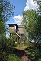
Observation tower


Individual evidence
- ↑ www.hasenmoor.de Website of the municipality of Hasenmoor
- ↑ a b 2025-303 Hasenmoor (FFH area). Published by the Federal Agency for Nature Conservation . Retrieved February 7, 2019.
- ↑ a b c Management plan for the fauna-flora-habitat area DE-2025-303 "Hasenmoor" of the LLUR (PDF)