Ferrovia Tereza Cristina
| Ferrovia Tereza Cristina | |||||||||||||||||||||||||||||||||||||||||||||||||||||||||||||||||||||||||||||||||||||||||||||||||||||||||||||||||||||||||||||||||||||||||||||||||||||||||||||||||||||||||||||||||||||||||||||||||||||||||||||
|---|---|---|---|---|---|---|---|---|---|---|---|---|---|---|---|---|---|---|---|---|---|---|---|---|---|---|---|---|---|---|---|---|---|---|---|---|---|---|---|---|---|---|---|---|---|---|---|---|---|---|---|---|---|---|---|---|---|---|---|---|---|---|---|---|---|---|---|---|---|---|---|---|---|---|---|---|---|---|---|---|---|---|---|---|---|---|---|---|---|---|---|---|---|---|---|---|---|---|---|---|---|---|---|---|---|---|---|---|---|---|---|---|---|---|---|---|---|---|---|---|---|---|---|---|---|---|---|---|---|---|---|---|---|---|---|---|---|---|---|---|---|---|---|---|---|---|---|---|---|---|---|---|---|---|---|---|---|---|---|---|---|---|---|---|---|---|---|---|---|---|---|---|---|---|---|---|---|---|---|---|---|---|---|---|---|---|---|---|---|---|---|---|---|---|---|---|---|---|---|---|---|---|---|---|---|
|
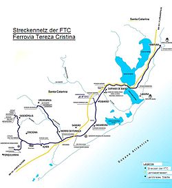
FTC Ferrovia Tereza Cristina SA route network
| |||||||||||||||||||||||||||||||||||||||||||||||||||||||||||||||||||||||||||||||||||||||||||||||||||||||||||||||||||||||||||||||||||||||||||||||||||||||||||||||||||||||||||||||||||||||||||||||||||||||||||||
| Route number : | EF-488 | ||||||||||||||||||||||||||||||||||||||||||||||||||||||||||||||||||||||||||||||||||||||||||||||||||||||||||||||||||||||||||||||||||||||||||||||||||||||||||||||||||||||||||||||||||||||||||||||||||||||||||||
| Route length: | 164 km | ||||||||||||||||||||||||||||||||||||||||||||||||||||||||||||||||||||||||||||||||||||||||||||||||||||||||||||||||||||||||||||||||||||||||||||||||||||||||||||||||||||||||||||||||||||||||||||||||||||||||||||
| Gauge : | 1000 mm ( meter gauge ) | ||||||||||||||||||||||||||||||||||||||||||||||||||||||||||||||||||||||||||||||||||||||||||||||||||||||||||||||||||||||||||||||||||||||||||||||||||||||||||||||||||||||||||||||||||||||||||||||||||||||||||||
|
|||||||||||||||||||||||||||||||||||||||||||||||||||||||||||||||||||||||||||||||||||||||||||||||||||||||||||||||||||||||||||||||||||||||||||||||||||||||||||||||||||||||||||||||||||||||||||||||||||||||||||||
The railway company FTC Ferrovia Tereza Cristina SA operates a route network in the Brazilian state of Santa Catarina . Originally the railway line was planned for the transport of coal between the mines of Lauro Müller and the port of Porto de Imbituba with a total length of 164 km. It was an isolated railway line that had no connection to other national railway lines. The operation was taken over under concession by the state railway company Rede Ferroviária Federal in 1996.
history
Around 1830 a coal deposit was discovered in the area of the Rio Tubarão and the first mining activities began in the area of the Rio Tuba as early as 1832, until an even more abundant coal deposit was discovered in the headwaters of the Rio Tubarão in 1861. The English explorers then founded the mining company The Tubarão Coal Mining Company Limited and a rail transport company, Donna Thereza Christina Railway Co. Ltd. As a result, the first railway connection to the coast was opened in 1884, but it was partially destroyed again in 1887 during a flood in the Rio Tubarão. Newly built railway bridges collapsed. The partial destruction of the line led to a lack of interest on the part of the British investors in the continuation of the project and it was not until 1902 that the line was put back into operation under state management. Since then, the main administration of the railway line has been in Imbituba . After further coal discoveries in the Criciúma region, the railway line was taken over by the private mining company Companhia Brasileira Carbonífera Araranguá (CBCA). New connecting lines were completed (Criciúma, Urussanga, Esplanada and Araranguá in 1927). The use of the railway by this company ended in 1940. It was not until 1957 that the railway line was integrated into the state railway company Rede Ferroviária Federal . After the dissolution of the RFFSA in 1997, the railway company was privatized again and the concession to operate it was given to Ferrovia Tereza Cristina SA (FTC), who owned the railway line for an amount equal to H. of R $ 18,510,000.00 for a 30-year usage license.
Today's railway line
After various stations and connections on the railway line were shut down in the 1970s under the direction of RFFSA, today's railway network with a route length of 164 km still exists as a connection between the following cities in the Brazilian state of Santa Catarina :
- Tubarão
- Criciúma
- Laguna
- Imbituba
- Urussanga
- Içara
- Jaguaruna
- Capivari de Baixo
- Morro da Fumaça
- Sangão
- Treviso
- Cocal do Sul
- Forquilhinha
