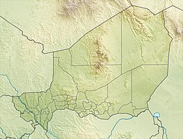
Wetland on central Niger II
|
Wetland in the middle Niger II
zone humide du moyen Niger II |
||
|
View from Benin over the river, on the other bank the wetland on the middle Niger II |
||
| location | Dosso region , Niger | |
| surface | 385.55 km² | |
| Geographical location | 11 ° 48 ' N , 3 ° 32' E | |
|
|
||
| Setup date | April 26, 2004 | |
The wetland on the middle Niger II ( French : Zone humide du moyen Niger II ) is a wetland in the Dosso region in Niger . It is protected under the Ramsar Convention .
Location and protection status
The wetland is on the left bank of the Niger River in the Dendi countryside . It extends over parts of the municipalities of Gaya , Tanda and Tounouga in the department of Gaya , which belongs to the Dosso region. In the north it borders on another Ramsar area, the previously established wetland on central Niger .
The wetland on the middle Niger II covers an area of 38,555 hectares and was placed under protection on April 26, 2004 under the Ramsar Convention. It runs over a length of 25 kilometers along the river that forms the state border with Benin . It consists of a floodplain with several ponds and is partially flooded for about four to five months every year with the start of the rainy season in August.
fauna and Flora
The wetland is a retreat for various bird species. These include the black-headed heron , the purple heron , the cattle egret , the White-winged tern , the Witwenpfeifgans , the little egret , the black-winged stilt , the ruff , the brown glossy ibis , the African Sacred Ibis , the Sandpiper and the Green Sandpiper . In addition, capotters , hussar monkeys , ichneumons , hippos , African manatees and pale foxes live here . Among the fish species are Hippopotamyrus pictus and Nannocharax occidentalis .
In the plant world, African baobabs shape the landscape. Other notable plants are the Ethiopian palmyra palm , the shea tree , the shrub Neocarya macrophylla and the sweet grass species Anthephora nigritana and Echinochloa stagnina . The neophytes include the thick-stemmed water hyacinth and the cattail type Typha domingensis .
Settlements
The main settlements in the area include:
- in the municipality of Gaya the city center and the village of Tara in the rural municipality area,
- the main town in the rural community of Tanda (the village of the same name),
- in the rural municipality of Tounouga also the main town (the village of the same name Tounouga) and the villages Dolé , Gatawani Béri, Gatawani Kaina and Koma.
See also
literature
- Ali Alhassane: Indicateurs d'existence des avantages potentiels des écosystèmes du site Ramsar du moyen Niger II. Cas des écosystèmes de Gatawani Kaina et Gatawani Béri (commune rurale de Tounouga) . Center Régional d'Enseignement Spécialisé en Agriculture (CRESA), Niamey 2010.
Web links
- Zone Humide du Moyen Niger II. In: Ramsar Sites Information Service. April 13, 2018(English).
Individual evidence
- ↑ a b National Repertoire des Localités (ReNaLoc). (RAR; 11.3 MB) Institut National de la Statistique de la République du Niger, July 2014, pp. 160–166 , accessed on August 7, 2015 (French).
- ↑ a b Système de zones humides de la region du fleuve. (PDF) map. Direction de la Faune, de la Pêche et de la Pisciculture, March 2001, accessed on March 10, 2019 (French).
- ↑ zone Humide du Moyen Niger II. In: Ramsar Sites Information Service. April 13, 2018, accessed March 25, 2019 .
- ↑ Ali Laouel Abagana, Issa Mariama Ali Omar . Humide Zone du Moyen Niger II Fiche descriptive Ramsar. (PDF) In: Ramsar Sites Information Service. January 1, 2005, accessed March 25, 2019 (French).


