Feuerbacher Heide
|
Landscape protection area "Feuerbacher Heide"
|
||
|
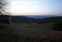
Western section of the Feuerbacher Heide |
||
| location | State capital Stuttgart in Baden-Württemberg , Germany | |
| surface | 21.3 ha | |
| Identifier | 1.11.007 | |
| WDPA ID | 320793 | |
| Geographical location | 48 ° 48 ' N , 9 ° 10' E | |
|
|
||
| Setup date | November 10, 1961 | |
| administration | City administration Stuttgart | |
The Feuerbacher Heide (up to 1500 also Frauenberger Heide or Hundsmaul) is an extensive, park-like green area in the north of the Stuttgart district, which largely consists of meadows grazed by sheep seasonally, but also includes an allotment area. It is the northern slope facing the Feuerbach district of the highest elevation of the north district with the Bismarck Tower , a popular viewpoint above the city on the Gähkopf (409 m above sea level). The Feuerbacher Heide extends from the residential street of the same name in the west, which begins at the Doggenburg, to the grounds of the TC Weissenhof tennis club in the east and is bordered in the north by the main street Am Kräherwald, which separates the Feuerbacher Heide from the Kräherwald and thus far into the forest area that extends west of Stuttgart separates. In the northeast it merges into the Killesberg district and has a green connection to the Killesberg Park . Thus, the Feuerbacher Heide can of than the outermost and highest part of Green U be considered.
Around 1480, Feuerbach, Cannstatt and Stuttgart, whose markings collided near Frauenberg Castle on the area also known as Frauenberger Heide, repeatedly because of the grazing rights that are dependent on the municipal boundaries. An inspection card dates from 1574 and is one of the oldest in Stuttgart and Cannstatt. The dispute could not be finally settled until 1649. In the 19th century executions took place on the Feuerbacher Heide after the place of execution in front of the Hauptstätter Tor, i. H. the previous execution site at today's Wilhelmsplatz was moved in 1811 from Hauptstätter Strasse to Feuerbacher Heide. For example, the poisoner Christiane Ruthardt was beheaded there with the sword in 1845.
There are architecturally and culturally interesting residential buildings on the street of the same name in the west of the Feuerbacher Heide and in the rest of the adjacent residential area:
- The villa Kahn of the architect Paul Schmitthenner in the Feuerbacher Heide
- The former Villa Levi (also Salamander Villa) by the architects Hugo Schlösser and Johann Weirether in the Feuerbacher Heide.
- The Zerweck house by the architect Paul Schmitthenner in the Feuerbacher Heide
- The house of Dr. Gustav Einstein, Feuerbacher Heide 78, today Anzengruberstr. 27
- The Villa Porsche of the architects Paul Bonatz and Fritz Scholer on Feuerbacher Weg
- The Villa Roser , also built by Paul Schmitthenner
- The Landhaus Roser by Paul Bonatz
- The Theodor-Heuss-Haus on Feuerbacher Weg
Landscape protection area
The areas west of the Feuerbacher Weg in the Stuttgart district and the unwooded areas between the northern edge of the Kräherwald and the construction area on Holbeinweg and on Grünewaldstrasse in the Stuttgart and Feuerbach districts were designated by the mayor's office of the city of Stuttgart on November 10, 1961 under the protection area number 1.11 .007 designated as a landscape protection area. The LSG has a size of 21.3 hectares.
Individual evidence
- ↑ Heinz Krämer: A boy from Feuerbach remembers
- ↑ Jürgen Hagel, Cannstatt and his history, Silberburgverlag, 2002, ISBN 3-87407-529-X
- ↑ Hans-Ulrich Schwarz: The University Maintenance Feuerbach (1477-1825) , Mohr Verlag, Tübingen, 1981, ISBN 3-16-444081-2 .
- ↑ Felix Burkhard: Around the Feuerbacher Heide in Feuerbacher Sunday from July 6, 1975 .


