Fire Island
| Fire Island | ||
|---|---|---|
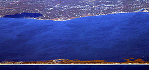
| Fire Island in the foreground, Long Island in the background | ||
| Waters | Atlantic Ocean | |
| Geographical location | 40 ° 39 ′ N , 73 ° 9 ′ W | |
|
|
||
| length | 48 km | |
| width | 1 km | |
| surface | 48 km² | |
| Highest elevation | 1 m | |
| Location of Fire Island | ||
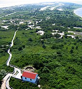
Fire Island is a barrier island , approximately 30 miles long and 1 km wide, in Suffolk County on the southern shore of Long Island in the US state of New York .
It is separated from Long Island by the up to seven miles wide Great South Bay , a natural harbor. The island and resorts are mainly accessible by the numerous ferries that cross Great South Bay or by private craft. A small part of the island at the western end is accessible from Long Island via the Robert Moses Causeway (also known as the Captree Causeway); the east end can be reached via New York State Route 46 . There is no straight road across the island.
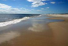
Almost the entire island is under nature protection: except for the western 8 km it forms the Fire Island National Seashore . To the west it forms Robert Moses State Park , which is one of the popular recreational areas in the New York region .
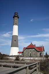
The Fire Island Lighthouse is a landmark that can be seen from afar, just east of Robert Moses State Park.
Fire Island residents
The communities of Ocean Beach and Saltaire , within Fire Island National Seashore, are car-free zones during the summer travel season ( Memorial Day through Labor Day ) and only allow pedestrian and bicycle traffic. In Ocean Beach, however, these regulations only apply by the hour. There are some driving licenses for year-round residents and out-of-season suppliers.
Fire Island also has a number of settlements ( hamlets ) without their own municipal legal forms. Two of these hamlets, known as Fire Island Pines and Cherry Grove, have a reputation for being a popular getaway for gay vacationers.
Historical
After a few storms created openings (e.g. Moriches Inlet ) in the formerly longer barrier island in the 1930s and divided the island, the currents between the open sea and the inland water behind the barrier islands changed. Beach erosion is increasingly a problem , compounded by the construction of breakwaters to maintain these openings for pleasure craft .
Avant-garde poet Frank O'Hara was accidentally killed on July 25, 1966 while sleeping on the beach and being run over by a dune buggy. In his novel Lennon is dead , the German writer Alexander Osang describes Fire Island and its inhabitants and makes the island a central location of the novel.
One of the first significant gay communities developed on Fire Island. The Village People dedicated a song to the island on their first LP and in the 1970s the island was famous for their “tea dance parties” on Sundays at 5pm, where DJs played. They were happy to do it because the gay audience was more willing to experiment and it was easier to try out new records or sequences without worrying about all those who liked dancing. Together with the in-clubs in the city, which are frequented by many gays, part of the disco history was written there.
Locations
places
Hamlets and communities in the western part
- Atlantique
- Bayberry Dunes
- Cherry Grove
- Corneille Estates
- Davis Park / Ocean Ridge
- Dunewood
- Fair Harbor
- Fire Island Pines
- Kismet
- Lonelyville
- Ocean Bay Park
- Ocean Beach - The Ocean Beach community
- Point O'Woods
- Robbins rest
- Saltaire - The municipality of Saltaire
- Seaview
- Water Island
- West Fire Island - Island in Great South Bay
Hamlet in the eastern part
- Long Cove
- Watch Hill - with one of four visitor centers in the nature park
Parks
- Fire Island National Seashore
- Robert Moses State Park - A natural park on the western end of the island under the administration of New York State.
Waters
- Fire Island Inlet - The space between the west end of Fire Island and Jones Beach Island that allows hydroelectric vehicles to travel into the Atlantic Ocean from Great South Bay.
- Moriches Inlet - A small waterway at the eastern end of the island, which connects Great South Bay or Moriches Bay with the Atlantic Ocean (only created in 1931 by a storm surge).
- Great South Bay - The body of water between Fire Island and Long Island. Fire Island's northern border.
- Atlantic Ocean - The southern limit of Fire Island.
Web links
- Fire Iceland Chamber of Commerce (English)
- Fire Iceland Ferries (English)
- Fire Iceland Lighthouse (English)
- Main attractions on Fire Iceland, three important rules reveries (English)
- Zoomable map of the Fire Island National Seashore -Park with searchable place names (PDF) (en) from the National Park Service (321 kB)
- Geological Impact of the 1938 Hurricane (English)
Individual evidence
- ↑ Rosa Reitsamer: From “Disco” to DISCO ( Memento of the original from September 28, 2007 in the Internet Archive ) Info: The archive link was inserted automatically and has not yet been checked. Please check the original and archive link according to the instructions and then remove this notice.
- ^ Bill Brewster: Gay Pop ( September 28, 2007 memento on the Internet Archive ) , formerly viewed on djhistory.com on March 29, 2007


