Fluchthorn (Valais Alps)
| Escape horn | ||
|---|---|---|
|
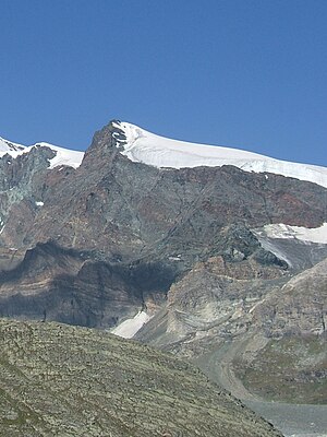
Fluchthorn and Schwarzberg Glacier from the east, from the Ofental |
||
| height | 3795 m above sea level M. | |
| location | Valais , Switzerland | |
| Mountains | Valais Alps | |
| Dominance | 0.48 km → Strahlhorn | |
| Notch height | 71 m ↓ escape pass | |
| Coordinates | 636 847 / 96791 | |
|
|
||
| Normal way | Hochtour (vergletschert) from the Britanniahütte from | |
The Fluchthorn is 3795 m above sea level. M. high summit in the Allalin group at the end of the Saas Valley in Switzerland . It is a popular ski tour in winter. The Fluchthorn is a secondary peak of the Strahlhorn and rises in its northeast ridge. This continues over the Schwarzberg to the dam of the Mattmarksee . The Schwarzberg Glacier lies in the southeast of the ridge and the Allalin Glacier in the northwest .
location
The following map shows the location of the Fluchthorn within the Valais Alps , the box map (right) within the entire Alps.
rise
The normal route leads from the Britanniahütte over the Allalin Glacier in the direction of Adlerpass , at the level of the Allalinhorn you reach the summit southwards.
Literature and maps
- National map of Switzerland 1: 25,000, sheet 284S, Mischabel ski tour map
Web links
- www.hikr.org: Tour reports Fluchthorn


