Arcata-Eureka Airport
| Arcata | ||
|---|---|---|
|
|
||
| Characteristics | ||
| ICAO code | KACV | |
| IATA code | ACV | |
| Coordinates | ||
| Height above MSL | 67 m (220 ft ) | |
| Transport links | ||
| Distance from the city center | 12 km north of Arcata , 19 km north of Eureka |
|
| Street |
|
|
| Basic data | ||
| operator | Humboldt County | |
| surface | 301 hectares | |
| Terminals | 1 | |
| Passengers | 132,659 (2017) | |
| Air freight | 115 t (2017) | |
| Flight movements |
42,174 (2015/16) | |
| Runways | ||
| 01/19 | 1372 m × 46 m asphalt |
|
| 14/32 | 1843 m × 46 m asphalt |
|
The Arcata Airport (also airport Arcata ) is an airport in McKinleyville . The catchment area includes Humboldt County , including the two eponymous localities Arcata and Eureka . The airport is the official entry airport for civil aircraft into the United States.
The airport was built by the US Navy during World War II to test systems for preventing condensation on aircraft windows. Today the airport is used commercially on the one hand and for private air traffic on the other. The airlines Horizon Air and United Airlines offer scheduled services here.
In 2005, 102,000 arriving and 104,000 departing passengers were handled on 4,370 flights. The Horizon Air line carried 66.29% of the passengers, the rest flew with United Airlines . The punctuality was 78% for outgoing and 79% for arriving aircraft. In addition to the passengers, 207,291 kg of goods were handled.
Facilities
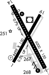
Arcata-Eureka Airport has an area of around 3 km 2 and there are two runways available:
- Runway 01/19: 1,372 x 45 m, surface: asphalt
- Runway 14/32: 1,843 x 46 m, surface: asphalt
Because the airport is on California's Pacific coast, it falls under the jurisdiction of the California Coastal Commission . Major changes, such as changing the area or the fence, must be approved by the Commission.
The approach to runway 32 is via the busy Central Avenue . The runway beacons initially put road traffic at risk from glare . This became particularly clear in bad weather, when the luminosity of the lights was additionally increased and then reflected by water on the roadway. The FAA's Office of Aviation Research, Airport Technology Research and Development Branch remedied this by adding bezels to the lights that prevented the roadway from being lit, but the lights continued to work for approaching aircraft served their purpose.
Airlines and destinations
-
Alaska Airlines
- Horizon Air (Los Angeles, Portland (OR), Redding)
-
United Airlines
- United Express operated by SkyWest (Crescent City, Sacramento, San Francisco)
Web links
Individual evidence
- ↑ a b AirportIQ 5010: California Redwood Coast-Humboldt County. GCR1.com, accessed October 16, 2017 .
- ^ A b California Air Traffic Statistical Reports. DOT.CA.gov, accessed July 30, 2018 .
- ↑ Section 6. United States Customs Service Airports ( Memento of February 5, 2012 in the Internet Archive )
- ↑ Senate Joint Resolution No. 12 ( Page no longer available , search in web archives ) Info: The link was automatically marked as defective. Please check the link according to the instructions and then remove this notice.
- ↑ humboldt.ca.us Aviation / Airports
- ↑ Arcata / Eureka (ACV) Airport Fact Sheet
- ^ California Coastal Commission March 2002 Meeting Agenda
- ↑ Design and Installation of Flasher Baffles at the Arcata / Eureka Airport ( Memento from September 26, 2006 in the Internet Archive ) (PDF; 264 kB)

