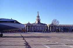
Kadala Airport
| Kadala Airport | |
|---|---|

|
|
| Characteristics | |
| ICAO code | UIAA |
| IATA code | HTA |
| Coordinates | |
| Height above MSL | 692 m (2270 ft ) |
| Transport links | |
| Distance from the city center | 13.5 km west of Tschita |
| train | Trans-Siberian Railway |
| Basic data | |
| opening | 1932 |
| operator | AO AeroTschita (100% Novaport ) |
| surface | 0.9 ha |
| Terminals | 2 |
| Passengers | 318,451 (2016) |
| Air freight | 3100 t (2016) |
| Start-and runway | |
| 11/29 | 2800 m × 56 m concrete |
The Kadala Airport ( IATA : HTA , ICAO : UIAA ) is an international airport in Chita in Siberia . It opened in 1932.
Location and connection
The airport is about 13.5 km west of Chita.
It has a stop on the Trans-Siberian Railway (route km 6009). The Russian highway R258 , which connects Chita with Irkutsk , runs a few kilometers away .
State 2015
The airport is equipped to accommodate the aircraft types Antonov An- 124-100, Airbus A319 , A320 , A321 , Boeing 757-200, Boeing 737 , Boeing 767 , Ilyushin Il-76 , Tupolev Tu-154 and all types of helicopters.
Web links
Commons : Kadala Airport - Collection of pictures, videos and audio files
Individual evidence
- ↑ Archive link ( Memento of the original from July 15, 2015 in the Internet Archive ) Info: The archive link was inserted automatically and has not yet been checked. Please check the original and archive link according to the instructions and then remove this notice.
- ^ History of Novaport. Novaport , accessed October 2, 2017 (Russian).
- ↑ a b Russian Aviation Agency : Passenger Statistics of Russian Airports 2015/2016. (PDF) Retrieved April 21, 2017 (Russian).